File:Zernez-Dorf.jpg
Size of this preview: 800 × 533 pixels. Other resolutions: 320 × 213 pixels | 640 × 427 pixels | 1,024 × 683 pixels | 1,200 × 800 pixels.
Original file (1,200 × 800 pixels, file size: 1.19 MB, MIME type: image/jpeg)
Captions
Captions
Add a one-line explanation of what this file represents
Summary
edit
| Description |
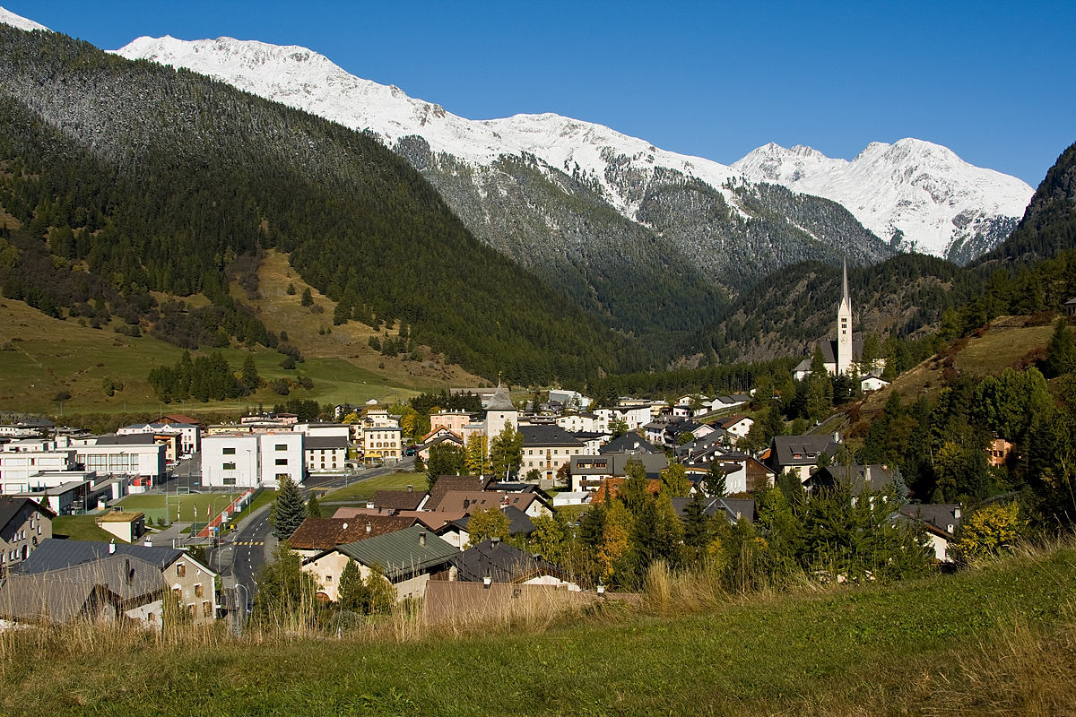
Deutsch: Das Dorf Zernez, Grenze zwischen dem Ober- und Unterengadin.
Linke bewaldete Schulter im Vordergrund gehört zur Piz d'Urezza (2906). Die beiden grossen schneebdedeckten Schultern in der Bildmitte und links davon gehören beide zu Piz dal Ras (3025). Während die Spitze selber nicht zu sehen ist, ist die Erhebung der vorderen Schulter Pt. 2953 (Spi d'Arpschella und Spi da Bunalouna). Die hintere Schulter ist mit dem Flurnamen Mundeis bezeichnet (Piz Spadlas (2335.9) ist knapp verdeckt). Die weissen Spitzen im Hintergrund gehören alle zur Piz Murtera (3044), die vorderste Erhebung heisst Piz Chastè (2850). Bewaldete Schulter am rechten Bildrand gehört zur Piz Sursassa (2968). Muttas da Clüs (1684) hinter der Kirchturmspitze. English: Zernez in Switzerland. Left: Piz d'Urezza (2906). Piz dal Ras (3025). Background: Piz Murtera (3044) and Piz Chastè (2850). Muttas da Clüs (1684) behind church |
||||
| Date | |||||
| Source | Own work | ||||
| Author |
|
Licensing
edit
I, the copyright holder of this work, hereby publish it under the following licenses:

|
Permission is granted to copy, distribute and/or modify this document under the terms of the GNU Free Documentation License, Version 1.2 or any later version published by the Free Software Foundation; with no Invariant Sections, no Front-Cover Texts, and no Back-Cover Texts. A copy of the license is included in the section entitled GNU Free Documentation License. |
| This file is licensed under the Creative Commons Attribution-Share Alike 3.0 Unported license. | ||
| ||
| This licensing tag was added to this file as part of the GFDL licensing update. |
You may select the license of your choice.
| Annotations | This image is annotated: View the annotations at Commons |
File history
Click on a date/time to view the file as it appeared at that time.
| Date/Time | Thumbnail | Dimensions | User | Comment | |
|---|---|---|---|---|---|
| current | 08:14, 7 October 2008 | | 1,200 × 800 (1.19 MB) | Roland Zumbuehl (talk | contribs) | {{Information |Description={{de|1=Das Dorf Zernez, Grenze zwischen dem Ober- und Unterengadin}} |Source=Eigenes Werk (own work) |Author={{Bild-Picswiss}} |Date=2008-10-05 |Permission= |other_versions= }} <!--{{ImageUpload|full}}--> |
You cannot overwrite this file.
File usage on Commons
The following 4 pages use this file:
File usage on other wikis
The following other wikis use this file:
- Usage on als.wikipedia.org
- Usage on ar.wikipedia.org
- Usage on arz.wikipedia.org
- Usage on ca.wikipedia.org
- Usage on ceb.wikipedia.org
- Usage on cs.wikipedia.org
- Usage on de.wikipedia.org
- Usage on de.wikivoyage.org
- Usage on en.wikipedia.org
- Usage on eo.wikipedia.org
- Usage on es.wikipedia.org
- Usage on eu.wikipedia.org
- Usage on fa.wikipedia.org
- Usage on fr.wikipedia.org
- Usage on it.wikipedia.org
- Usage on ja.wikipedia.org
- Usage on kk.wikipedia.org
- Usage on ko.wikipedia.org
- Usage on la.wikipedia.org
- Usage on lld.wikipedia.org
- Usage on lmo.wikipedia.org
- Usage on nl.wikipedia.org
- Usage on nn.wikipedia.org
- Usage on pl.wikipedia.org
- Usage on pl.wikivoyage.org
- Usage on pt.wikipedia.org
- Usage on rm.wikipedia.org
- Usage on ru.wikipedia.org
- Usage on simple.wikipedia.org
- Usage on sv.wikipedia.org
- Usage on uk.wikipedia.org
- Usage on uz.wikipedia.org
- Usage on vec.wikipedia.org
- Usage on www.wikidata.org
- Usage on zh.wikipedia.org
View more global usage of this file.