File:Reliefkarte Aargau.png
Size of this preview: 678 × 599 pixels. Other resolutions: 272 × 240 pixels | 543 × 480 pixels | 869 × 768 pixels | 1,158 × 1,024 pixels | 2,113 × 1,868 pixels.
Original file (2,113 × 1,868 pixels, file size: 4.32 MB, MIME type: image/png)
Captions
Captions
Add a one-line explanation of what this file represents
| Description |
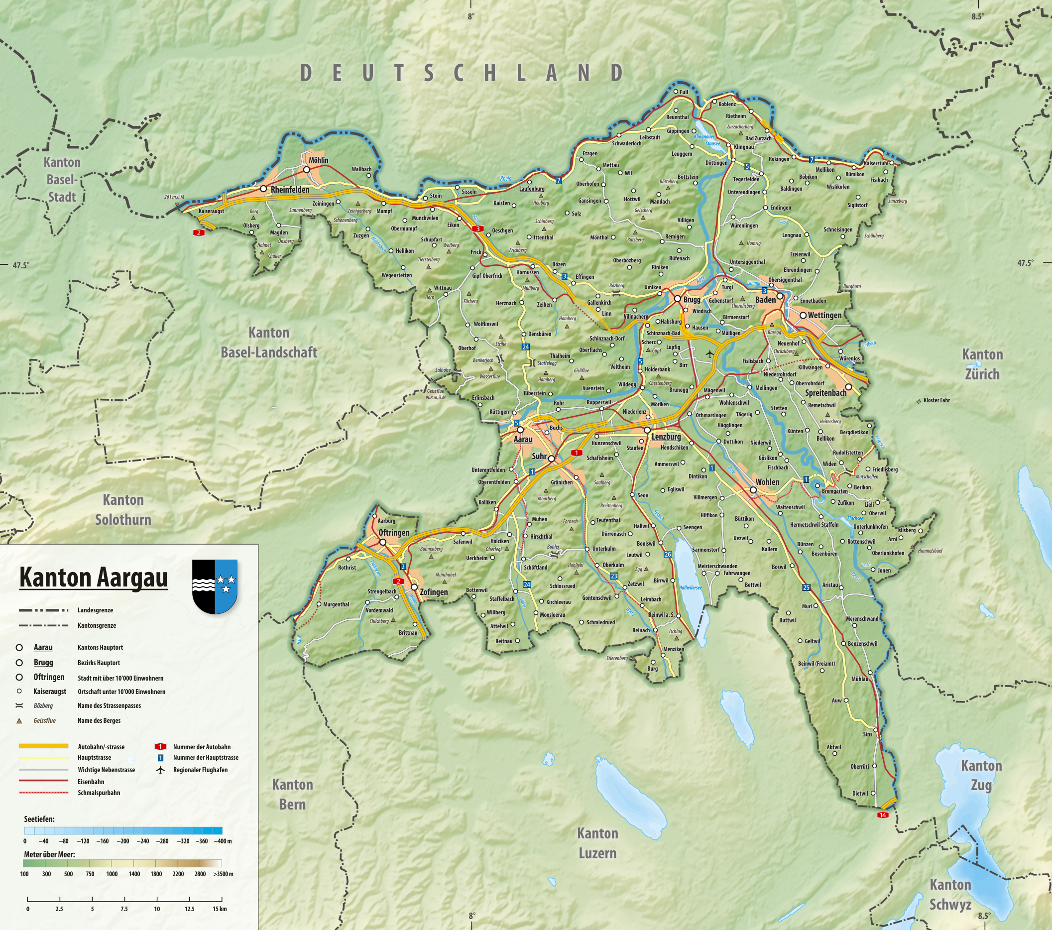
Deutsch: Reliefkarte des Kantons Aargau
Topographischer Hintergrund: NASA Shuttle Radar Topography Mission (public domain). SRTM3 v.2. |
||||||||
| Date | |||||||||
| Source | Own work | ||||||||
| Author | Tschubby | ||||||||
| Permission (Reusing this file) |
I, the copyright holder of this work, hereby publish it under the following licenses:
This file is licensed under the Creative Commons Attribution-Share Alike 2.5 Generic, 2.0 Generic and 1.0 Generic license.
You may select the license of your choice. |

File history
Click on a date/time to view the file as it appeared at that time.
| Date/Time | Thumbnail | Dimensions | User | Comment | |
|---|---|---|---|---|---|
| current | 18:29, 26 December 2021 | | 2,113 × 1,868 (4.32 MB) | Tschubby (talk | contribs) | {{Information |Description= |Source= |Date= |Author= |Permission= |other_versions= }} |
| 19:43, 18 July 2020 |  | 2,113 × 1,868 (4.32 MB) | Tschubby (talk | contribs) | {{Information |description= |date= |source= |author= |permission= |other versions= }} | |
| 09:59, 23 January 2019 |  | 2,113 × 1,868 (4.32 MB) | Tschubby (talk | contribs) | {{Information |description= |date= |source= |author= |permission= |other versions= }} | |
| 14:21, 2 May 2016 |  | 2,117 × 1,871 (3.24 MB) | Tschubby (talk | contribs) | {{Information |Description= |Source= |Date= |Author= |Permission= |other_versions= }} | |
| 07:42, 17 April 2015 |  | 2,116 × 1,871 (4.54 MB) | Tschubby (talk | contribs) | {{Information |Description= |Source= |Date= |Author= |Permission= |other_versions= }} | |
| 07:40, 17 April 2015 |  | 2,116 × 1,871 (4.55 MB) | Tschubby (talk | contribs) | {{Information |Description= |Source= |Date= |Author= |Permission= |other_versions= }} | |
| 14:35, 27 August 2013 |  | 2,117 × 1,871 (4.54 MB) | Tschubby (talk | contribs) | {{Information |Description= {{de| Reliefkarte des Kantons Aargau}} Topographischer Hintergrund: [http://www2.jpl.nasa.gov/srtm NASA Shuttle Radar Topography Mission] (public domain). SRTM3 v.2. |Source={{own}} |Date= 2013-08-27 |Author= [[:de:User:Tsch... |
You cannot overwrite this file.
File usage on Commons
The following 2 pages use this file:
File usage on other wikis
The following other wikis use this file:
- Usage on als.wikipedia.org
- Usage on de.wikipedia.org
- Usage on en.wikipedia.org
- Usage on ja.wikipedia.org
- Usage on simple.wikipedia.org
- Usage on si.wikipedia.org
- Usage on sl.wikipedia.org
- Usage on sv.wikipedia.org
- Usage on uz.wikipedia.org
- Usage on www.wikidata.org