File:Karte der Krim.png
Size of this preview: 800 × 520 pixels. Other resolutions: 320 × 208 pixels | 640 × 416 pixels | 1,024 × 666 pixels | 1,280 × 833 pixels | 2,283 × 1,485 pixels.
Original file (2,283 × 1,485 pixels, file size: 1,014 KB, MIME type: image/png)
Captions
Captions
Add a one-line explanation of what this file represents
Summary
edit| Description |
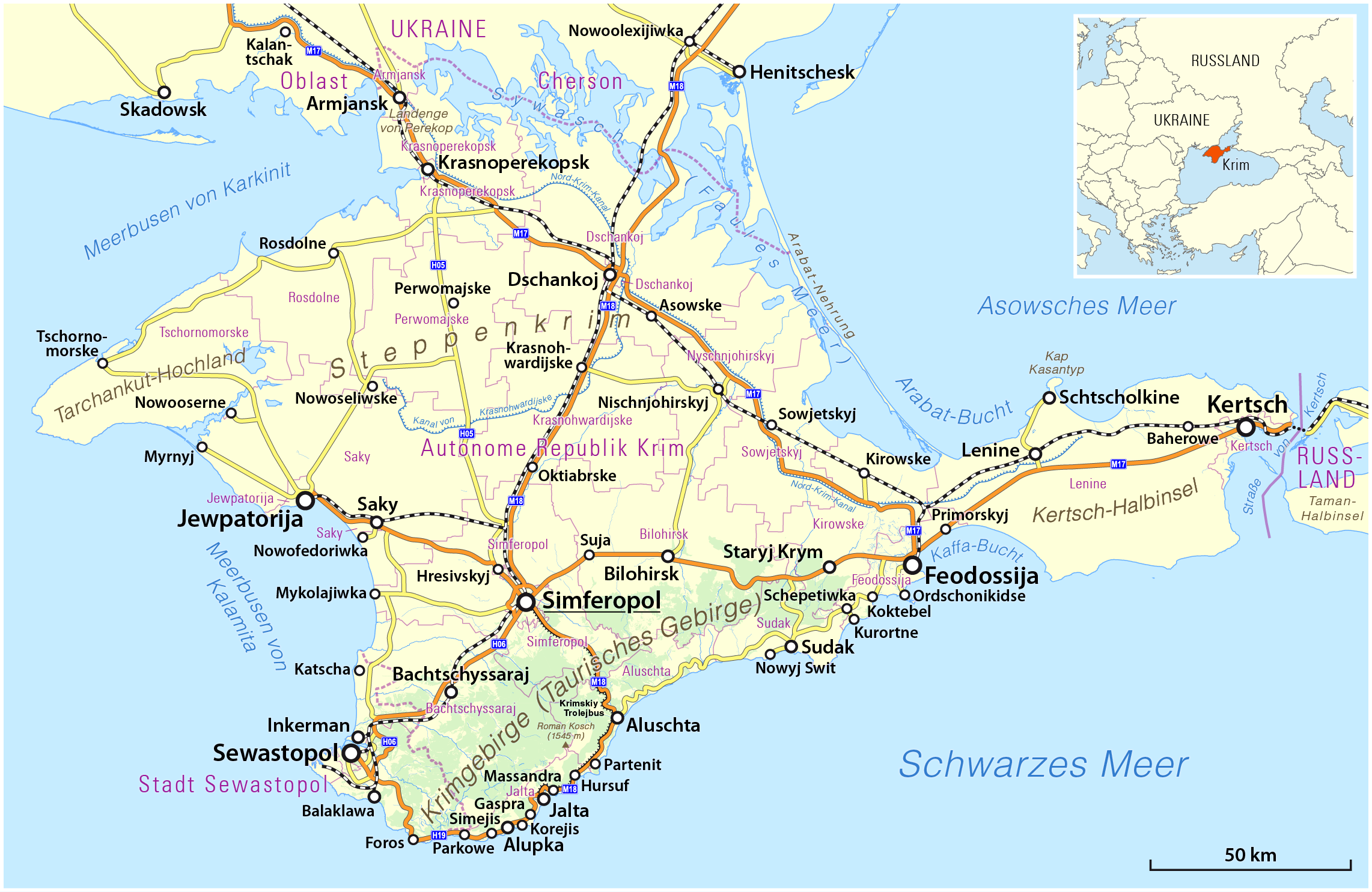
Deutsch: Topographische Karte der Krim, (de:Deutsch-russische Transkription bzw. de:Transkription_(Schreibung)#Kyrillisch)
English: Topographic map of the Crimea peninsula |
|||
| Date | see file history | |||
| Source |
Own work, using
|
|||
| Author | Maximilian Dörrbecker (Chumwa) | |||
| Permission (Reusing this file) |
This file is licensed under the Creative Commons Attribution-Share Alike 2.0 Generic license.
Sie dürfen das Bild zu den folgenden Bedingungen nutzen:
|
|||
| Other versions |
|


File history
Click on a date/time to view the file as it appeared at that time.
| Date/Time | Thumbnail | Dimensions | User | Comment | |
|---|---|---|---|---|---|
| current | 23:10, 1 December 2016 | | 2,283 × 1,485 (1,014 KB) | Chumwa (talk | contribs) | |
| 02:00, 9 April 2014 |  | 2,283 × 1,485 (643 KB) | Centovalli (talk | contribs) | optipng | |
| 19:11, 8 April 2014 |  | 2,283 × 1,485 (1,014 KB) | Chumwa (talk | contribs) | ||
| 05:20, 7 April 2014 |  | 2,283 × 1,485 (1,014 KB) | Chumwa (talk | contribs) | ||
| 02:21, 6 April 2014 |  | 2,283 × 1,485 (643 KB) | Cheschtenebaum (talk | contribs) | optipng | |
| 19:50, 5 April 2014 |  | 2,283 × 1,485 (1,013 KB) | Chumwa (talk | contribs) | ||
| 09:28, 31 March 2014 |  | 2,283 × 1,485 (653 KB) | Kopiersperre (talk | contribs) | optipng | |
| 18:23, 26 March 2014 |  | 2,283 × 1,485 (1.01 MB) | Cheschtenebaum (talk | contribs) | Azowske --> Asowske | |
| 17:32, 24 March 2014 |  | 2,283 × 1,485 (1,012 KB) | Chumwa (talk | contribs) | ||
| 15:18, 22 March 2014 |  | 2,283 × 1,485 (1,012 KB) | Chumwa (talk | contribs) |
You cannot overwrite this file.
File usage on Commons
The following 10 pages use this file:
File usage on other wikis
The following other wikis use this file:
- Usage on als.wikipedia.org
- Usage on ar.wikipedia.org
- Usage on ba.wikipedia.org
- Usage on be.wikipedia.org
- Usage on bg.wikipedia.org
- Usage on ca.wikipedia.org
- Usage on crh.wikipedia.org
- Usage on de.wikipedia.org
- Krim
- Simferopol
- Sewastopol
- Feodossija
- Benutzer:Chumwa
- Krymskyj trolejbus
- Liste ukrainischer Inseln
- Annexion der Krim 2014
- Referendum über den Status der Krim
- Wikipedia:Kartenwerkstatt/Karte des Tages/Galerie
- Benutzer:Chumwa/SomeOfMyFiles
- Wikipedia:Hauptseite/Archiv/24. März 2021
- Wikipedia:Hauptseite/Archiv/25. März 2021
- Wikipedia:Hauptseite/Archiv/26. März 2021
- Ekim Kara
- Kefessija
- Dschewat Kara
- Usage on dsb.wikipedia.org
- Usage on el.wikipedia.org
- Usage on en.wikipedia.org
- Usage on en.wiktionary.org
- Usage on es.wikipedia.org
- Usage on et.wikipedia.org
- Usage on fa.wikipedia.org
- Usage on fi.wikipedia.org
- Usage on fi.wikivoyage.org
- Usage on fo.wikipedia.org
- Usage on frr.wikipedia.org
- Usage on fy.wikipedia.org
- Usage on ga.wikipedia.org
View more global usage of this file.