File:LatinEmpire.png

Size of this preview: 800 × 396 pixels. Other resolutions: 320 × 158 pixels | 640 × 316 pixels | 1,024 × 506 pixels | 1,715 × 848 pixels.
Original file (1,715 × 848 pixels, file size: 1.82 MB, MIME type: image/png)
Captions
Captions
Add a one-line explanation of what this file represents
Summary
edit
| Description |
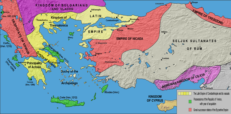
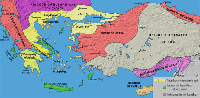
English: The borders of the Latin Empire and Byzantine Empire after the 4th crusade (1204) up to the Treaty of Nymphaeum in 1214. Borders are approximate. Русский: Границы Латинской и Византийской империй после Четвёртого крестового похода (1204) до Нимфейского мира (1214). Границы приблизительны. |
| Date | |
| Source | own work; base map from Natural Earth |
| Author | Varana |
| Permission (Reusing this file) |
GDFL, CC-BY-SA |
| Other versions | Derivative works of this file: LatinEmpire-ar.png |
Licensing
edit
I, the copyright holder of this work, hereby publish it under the following licenses:

|
Permission is granted to copy, distribute and/or modify this document under the terms of the GNU Free Documentation License, Version 1.2 or any later version published by the Free Software Foundation; with no Invariant Sections, no Front-Cover Texts, and no Back-Cover Texts. A copy of the license is included in the section entitled GNU Free Documentation License. |
| This file is licensed under the Creative Commons Attribution-Share Alike 3.0 Unported license. | ||
| ||
| This licensing tag was added to this file as part of the GFDL licensing update. |
This file is licensed under the Creative Commons Attribution-Share Alike 2.5 Generic, 2.0 Generic and 1.0 Generic license.
- You are free:
- to share – to copy, distribute and transmit the work
- to remix – to adapt the work
- Under the following conditions:
- attribution – You must give appropriate credit, provide a link to the license, and indicate if changes were made. You may do so in any reasonable manner, but not in any way that suggests the licensor endorses you or your use.
- share alike – If you remix, transform, or build upon the material, you must distribute your contributions under the same or compatible license as the original.
You may select the license of your choice.
File history
Click on a date/time to view the file as it appeared at that time.
| Date/Time | Thumbnail | Dimensions | User | Comment | |
|---|---|---|---|---|---|
| current | 18:45, 1 May 2017 | | 1,715 × 848 (1.82 MB) | Mélomène (talk | contribs) | More colours, and details since Malcolm Barber's “The Crusader States”, Yale University Press 2012, ISBN 978-0-300-11312-9. |
| 22:04, 4 May 2011 |  | 1,715 × 848 (1.54 MB) | Maproom (talk | contribs) | Corrected aspect ratio again - and this time I haven't (I hope) trimmed off Greece etc. | |
| 13:42, 3 March 2011 | 1,715 × 701 (1.03 MB) | Decius (talk | contribs) | Reverted to version as of 16:53, 18 February 2009 | ||
| 19:32, 1 March 2011 |  | 1,413 × 701 (943 KB) | Maproom (talk | contribs) | Corrected aspect ratio, by a factor of 1.214. | |
| 16:53, 18 February 2009 | 1,715 × 701 (1.03 MB) | Varana (talk | contribs) | Changed colour scheme for readability by colour-blind people. | ||
| 09:44, 24 September 2006 | 1,715 × 701 (1.11 MB) | Varana (talk | contribs) | {{Information |Description=The Latin Empire and the Partition of the Byzantine Empire after the 4th crusade, c. 1204; borders are approximate |Source=own work; base map from [http://www.shadedrelief.com/natural/ Natural Earth] |Date=24-09-2006 |Author=[ht |
You cannot overwrite this file.
File usage on Commons
The following 9 pages use this file:
File usage on other wikis
The following other wikis use this file:
- Usage on af.wikipedia.org
- Usage on als.wikipedia.org
- Usage on ar.wikipedia.org
- Usage on arz.wikipedia.org
- Usage on ast.wikipedia.org
- Usage on azb.wikipedia.org
- Usage on ba.wikipedia.org
- Usage on be.wikipedia.org
- Usage on bg.wikipedia.org
- Usage on br.wikipedia.org
- Usage on ca.wikipedia.org
- Usage on cs.wikipedia.org
- Usage on de.wikipedia.org
- Usage on de.wikivoyage.org
- Usage on el.wikipedia.org
- Usage on en.wikipedia.org
- Usage on en.wikibooks.org
- Usage on eo.wikipedia.org
- Usage on es.wikipedia.org
View more global usage of this file.