File:Kaiserstuhl-alemannisch.png
Kaiserstuhl-alemannisch.png (405 × 395 pixels, file size: 240 KB, MIME type: image/png)
Captions
Captions
Beschribig
edit
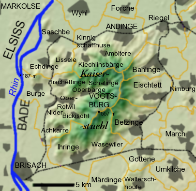
Topographischi Charte vum Kaiserstuehl in Südbade, erstellt mit Overlays un projeziert uf e Usschnitt vu DEMsuedlicher-oberrhein.jpg, mit alemannische Ortsbezeichnige fer die alemannisch Wikipedia.
Gmeinde mit Stadträcht steht in Grossbuechstabe. Gmeinämme sin in eweng grössere Schrift, igmeinditi Ortschafte in eweng chleinere.
E unbeschriftiti Version isch Kaiserstuhl-topographie.png, wo mer au fer anderi Sproche verwende cha.
Summary
edit
Topographische Karte des Kaiserstuhlgebirges bei Freiburg im Breisgau, erstellt mit Overlays projiziert auf einen Ausschnitt von DEMsuedlicher-oberrhein.jpg, mit alemannischen Ortsbezeichnungen, für die alemannische Wikipedia.
Gemeindennamen stehen in etwas größerer Schrift als eingemeindete Orte, Städte in Großbuchstaben entsprechend der Namenskonventionen in amtlichen topographischen Karten.
Die unbeschriftete Version der Karte ist Kaiserstuhl-topographie.png, zur Verwendung für anderssprachige Wikipedias
Summary
edit
Topographic map in Alemannic of the Kaiserstuhl in South West Germany. Based on DEMsuedlicher-oberrhein.jpg.
Licensing
edit

|
Permission is granted to copy, distribute and/or modify this document under the terms of the GNU Free Documentation License, Version 1.2 or any later version published by the Free Software Foundation; with no Invariant Sections, no Front-Cover Texts, and no Back-Cover Texts. A copy of the license is included in the section entitled GNU Free Documentation License. |
| This file is licensed under the Creative Commons Attribution-Share Alike 3.0 Unported license. | ||
| ||
| This licensing tag was added to this file as part of the GFDL licensing update. |
File history
Click on a date/time to view the file as it appeared at that time.
| Date/Time | Thumbnail | Dimensions | User | Comment | |
|---|---|---|---|---|---|
| current | 22:25, 8 August 2006 | | 405 × 395 (240 KB) | W-j-s (talk | contribs) | |
| 23:08, 5 August 2006 |  | 405 × 395 (206 KB) | W-j-s (talk | contribs) | ||
| 22:30, 5 August 2006 |  | 405 × 395 (200 KB) | W-j-s (talk | contribs) | == Beschreibung == Topographische Karte des Kaiserstuhls, erstellt mit Overlays projeziert auf einen Ausschnitt von DEMsuedlicher-oberrhein.jpg, mit alemannischen Ortsbezeichnungen, für die alemannische Wikipedia. |
You cannot overwrite this file.
File usage on Commons
There are no pages that use this file.
File usage on other wikis
The following other wikis use this file:
- Usage on als.wikipedia.org