File:Italian empire 1914.png
Size of this preview: 800 × 351 pixels. Other resolutions: 320 × 140 pixels | 640 × 281 pixels | 1,425 × 625 pixels.
Original file (1,425 × 625 pixels, file size: 38 KB, MIME type: image/png)
Captions
Captions
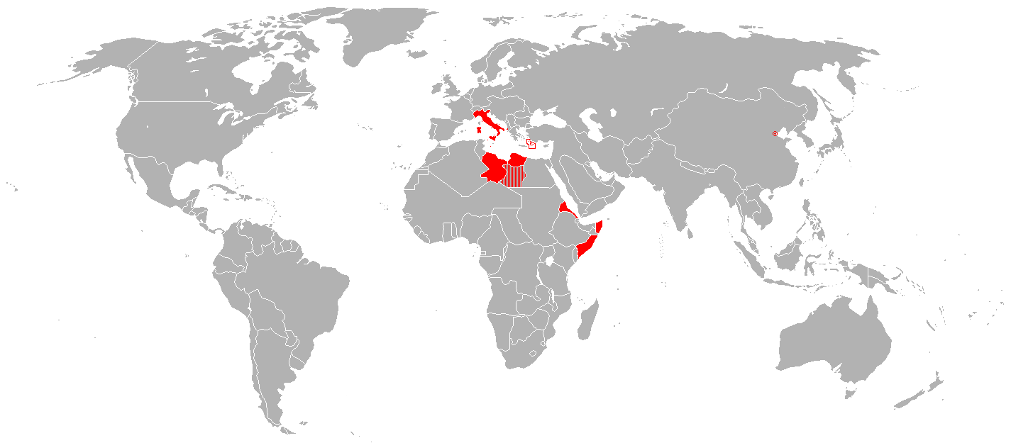
Map of the Italian Empire in 1914
Summary
edit
| Description |
English: Map of the Italian Empire in 1914. Of note, at this time, the Vatican was not independent from Italy (this occurred in 1929). The future colony of Libya is correctly shown in 1914 as the two separate Italian colonies it was at the time, Tripolitania and Fezzan. Cyrenaica is shown as a disputed area as both the United Kingdom and Italy laid claim to it. Minuscule Italian possessions are surrounded by red circling, including the small Italian holding of 46 hectares in Tianjin, a Chinese trading city which had numerous European territorial holdings. Mongolia is depicted as part of China; however it had already declared independence in 1911. Română: Hartă a Imperiului Italian în 1914. Vaticanul nu a fost stat independent până în 1929. Viitoarea colonie Libia este înfățișată așa cum era în 1914 – două colonii separate: Tripolitania și Cirenaica. Fezza este regiunea disputată de Italia și Regatul Unit. Posesiunile mai mici sunt încercuite cu roșu – insulele Dodecaneze și cele 46 ha din Tianjin. |
| Date | |
| Source | Own work (enwiki) |
| Author | R-41 |
Licensing
edit
| This work has been released into the public domain by its author, R-41 at English Wikipedia. This applies worldwide. In some countries this may not be legally possible; if so: R-41 grants anyone the right to use this work for any purpose, without any conditions, unless such conditions are required by law. |
Original upload log
edit
The original description page was here. All following user names refer to en.wikipedia.
- 2010-09-07 12:37 -kayac71- 1425×625× (29050 bytes) error in te map: west Jubaland (Somalia) was not Italian until 1924
- 2010-04-21 17:36 TheDJ 1425×625× (54081 bytes) convert bmp to png
- 2007-10-31 19:48 R-41 1425×625× (2672554 bytes) Map of the Italian colonial empire in 1914. Made by [[User:R-41]]
File history
Click on a date/time to view the file as it appeared at that time.
| Date/Time | Thumbnail | Dimensions | User | Comment | |
|---|---|---|---|---|---|
| current | 11:01, 25 July 2023 | | 1,425 × 625 (38 KB) | Randomastwritter (talk | contribs) | Nugaal border |
| 06:52, 14 August 2011 |  | 1,425 × 625 (28 KB) | OgreBot (talk | contribs) | (BOT): Reverting to most recent version; originally uploaded at en.wikipedia on 2010-09-07 12:37:50 by -kayac71- | |
| 06:52, 14 August 2011 |  | 1,425 × 625 (53 KB) | OgreBot (talk | contribs) | (BOT): Uploading old version of file from en.wikipedia; originally uploaded on 2010-04-21 17:36:41 by TheDJ | |
| 08:55, 13 August 2011 |  | 1,425 × 625 (28 KB) | File Upload Bot (Magnus Manske) (talk | contribs) | {{BotMoveToCommons|en.wikipedia|year={{subst:CURRENTYEAR}}|month={{subst:CURRENTMONTHNAME}}|day={{subst:CURRENTDAY}}}} {{Information |Description={{en|Map of the en:Italian Empire in 1914. Of note, at this time, the Vatican was not independent from |
You cannot overwrite this file.
File usage on Commons
There are no pages that use this file.
File usage on other wikis
The following other wikis use this file:
- Usage on als.wikipedia.org
- Usage on azb.wikipedia.org
- Usage on da.wikipedia.org
- Usage on de.wikipedia.org
- Usage on en.wikipedia.org
- Usage on es.wikipedia.org
- Usage on et.wikipedia.org
- Usage on fr.wikipedia.org
- Usage on gl.wikipedia.org
- Usage on it.wikipedia.org
- Usage on mk.wikipedia.org
- Usage on ms.wikipedia.org
- Usage on pap.wikipedia.org
- Usage on ro.wikipedia.org
- Usage on ru.wikipedia.org
- Usage on sd.wikipedia.org
- Usage on th.wikipedia.org
- Usage on ur.wikipedia.org
- Usage on www.wikidata.org
- Usage on zh.wikipedia.org