File:Elbe Einzugsgebiet.png
Size of this preview: 568 × 599 pixels. Other resolutions: 227 × 240 pixels | 455 × 480 pixels | 728 × 768 pixels | 971 × 1,024 pixels | 1,309 × 1,381 pixels.
Original file (1,309 × 1,381 pixels, file size: 1.96 MB, MIME type: image/png)
Captions
Captions
Add a one-line explanation of what this file represents
Summary
edit
| Description |
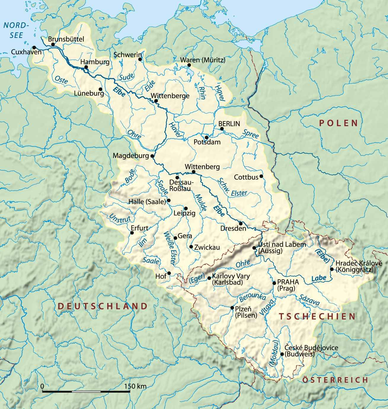
Čeština: Povodí Labe.
Deutsch: Einzugsgebiet der Elbe
English: Drainage basin of Elbe River
Polski: Zlewnia rzeki Łaby |
| Date | |
| Source | Own work |
| Author | NordNordWest |
| Other versions |
|

|
This map image could be re-created using vector graphics as an SVG file. This has several advantages; see Commons:Media for cleanup for more information. If an SVG form of this image is available, please upload it and afterwards replace this template with
{{vector version available|new image name}}.
It is recommended to name the SVG file “Elbe Einzugsgebiet.svg”—then the template Vector version available (or Vva) does not need the new image name parameter. |

|
This map has been made or improved in the German Kartenwerkstatt (Map Lab). You can propose maps to improve as well.
|
Licensing
edit
I, the copyright holder of this work, hereby publish it under the following licenses:

|
Permission is granted to copy, distribute and/or modify this document under the terms of the GNU Free Documentation License, Version 1.2 or any later version published by the Free Software Foundation; with no Invariant Sections, no Front-Cover Texts, and no Back-Cover Texts. A copy of the license is included in the section entitled GNU Free Documentation License. |
This file is licensed under the Creative Commons Attribution-Share Alike 3.0 Unported license.
- You are free:
- to share – to copy, distribute and transmit the work
- to remix – to adapt the work
- Under the following conditions:
- attribution – You must give appropriate credit, provide a link to the license, and indicate if changes were made. You may do so in any reasonable manner, but not in any way that suggests the licensor endorses you or your use.
- share alike – If you remix, transform, or build upon the material, you must distribute your contributions under the same or compatible license as the original.
You may select the license of your choice.
File history
Click on a date/time to view the file as it appeared at that time.
| Date/Time | Thumbnail | Dimensions | User | Comment | |
|---|---|---|---|---|---|
| current | 17:58, 28 March 2016 | | 1,309 × 1,381 (1.96 MB) | NordNordWest (talk | contribs) | upd |
| 18:20, 24 April 2008 |  | 1,309 × 1,381 (1.92 MB) | NordNordWest (talk | contribs) | == Beschreibung == {{Information |Description= {{de}} Einzugsgebiet der Elbe {{en}} Drainage basin of Elbe River |Source=self-made |Date=24-04-2008 |Author= Titus Groan |Permission= |other_versions= }} {{Kart |
You cannot overwrite this file.
File usage on Commons
The following 9 pages use this file:
File usage on other wikis
The following other wikis use this file:
- Usage on af.wikipedia.org
- Usage on als.wikipedia.org
- Usage on am.wikipedia.org
- Usage on ang.wikipedia.org
- Usage on an.wikipedia.org
- Usage on ar.wikipedia.org
- Usage on arz.wikipedia.org
- Usage on ast.wikipedia.org
- Usage on az.wiktionary.org
- Usage on be.wikipedia.org
- Usage on bh.wikipedia.org
- Usage on ca.wikipedia.org
- Usage on ceb.wikipedia.org
- Usage on cs.wikipedia.org
- Usage on da.wikipedia.org
- Usage on de.wikipedia.org
- Liste von Flüssen in Europa
- Liste von Städten und Orten an der Elbe
- Liste von Nebenflüssen der Elbe
- Elbgermanen
- Elbe
- Wikipedia:WikiProjekt Flussverlaufskarten
- Wikipedia Diskussion:WikiProjekt Flussverlaufskarten
- Benutzer:Derbrauni/Liste von Nebenflüssen der Elbe
- Benutzer:Aeroid/List DE NI-WL
- Benutzer:Aeroid/List DE NI-STD
- Benutzer:Aeroid/List DE NI-CUX
- Benutzer:Methodios/Elbgermanische Wanderungen
- Wikipedia:Kartenwerkstatt/Archiv/2016-03
- Benutzer:Aeroid/List DE HH-unmittelbar
- Benutzer:Kleeblatt187/SN-DD-eingeschränkt
- Wikipedia Diskussion:Hauptseite/Artikel des Tages/Archiv/Vorschläge/2021/Q3
- Benutzer:Wandelndes Lexikon/Babel
- Benutzer:Wandelndes Lexikon/Vorlage/Babel-Block
- Wikipedia Diskussion:Hauptseite/Artikel des Tages/Archiv/Vorschläge/2022/Q3
- Benutzer:Wandelndes Lexikon/Babel/Elbe
- Wikipedia:Hauptseite/Archiv/25. September 2022
- Benutzer:Wandelndes Lexikon
- Usage on dsb.wikipedia.org
- Usage on en.wikipedia.org
View more global usage of this file.