File:Freiburg-stadtteile.png

Size of this preview: 640 × 600 pixels. Other resolutions: 256 × 240 pixels | 681 × 638 pixels.
Original file (681 × 638 pixels, file size: 41 KB, MIME type: image/png)
File information
Structured data
Captions
Captions
Add a one-line explanation of what this file represents
Summary
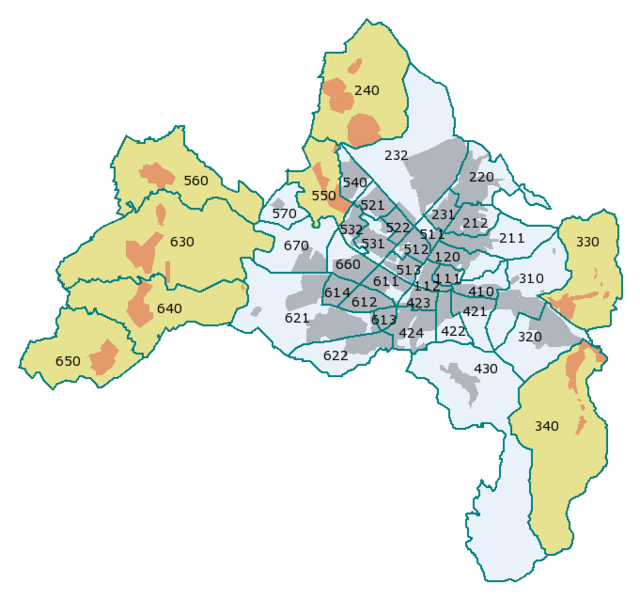
editStadtteile von Freiburg im Breisgau mit ihren amtlichen Nummern
- 111 Altstadt-Mitte
- 112 Altstadt-Ring
- 120 Neuburg
- 211 Herdern-Süd
- 212 Herdern-Nord
- 220 Zähringen
- 231 Brühl-Güterbahnhof
- 232 Brühl-Industriegebiet
- 240 Hochdorf ¹
- 310 Waldsee
- 320 Littenweiler
- 330 Ebnet ¹
- 340 Kappel ¹
- 410 Oberau
- 421 Oberwiehre
- 422 Mittelwiehre
- 423 Unterwiehre-Nord
- 424 Unterwiehre-Süd
- 430 Günterstal
- 511 Stühlinger-Beurbarung
- 512 Stühlinger-Eschholz
- 513 Alt-Stühlinger
- 521 Mooswald-West
- 522 Mooswald-Ost
- 531 Betzenhausen-Bischofslinde
- 532 Alt-Betzenhausen
- 540 Landwasser
- 550 Lehen ¹
- 560 Waltershofen ¹
- 570 Mundenhof
- 611 Haslach-Egerten
- 612 Haslach-Gartenstadt
- 613 Haslach-Schildacker
- 614 Haslach-Haid
- 621 St. Georgen-Nord
- 622 St. Georgen-Süd
- 630 Opfingen ¹
- 640 Tiengen ¹
- 650 Munzingen ¹
- 660 Weingarten
- 670 Rieselfeld
- 680 Vauban - fehlt noch, Karte zeigt Stand von 2006
¹ Orte mit Ortschaftsrat, in der Karte beige gefärbt.
Summary
editKarte selbst erstellt anhand der amtlichen Angaben. Bezirk 680 Vauban (früher Ostteil von 622 und südlichster Teil von 424) ist noch nicht eingetragen.
Licensing
edit
|
Permission is granted to copy, distribute and/or modify this document under the terms of the GNU Free Documentation License, Version 1.2 or any later version published by the Free Software Foundation; with no Invariant Sections, no Front-Cover Texts, and no Back-Cover Texts. A copy of the license is included in the section entitled GNU Free Documentation License.http://www.gnu.org/copyleft/fdl.htmlGFDLGNU Free Documentation Licensetruetrue |
| This file is licensed under the Creative Commons Attribution-Share Alike 3.0 Unported license. | ||
| ||
| This licensing tag was added to this file as part of the GFDL licensing update.http://creativecommons.org/licenses/by-sa/3.0/CC BY-SA 3.0Creative Commons Attribution-Share Alike 3.0truetrue |
File history
Click on a date/time to view the file as it appeared at that time.
| Date/Time | Thumbnail | Dimensions | User | Comment | |
|---|---|---|---|---|---|
| current | 14:59, 19 February 2006 |  | 681 × 638 (41 KB) | W-j-s (talk | contribs) | == Beschreibung: == Stadtbezirke von Freiburg, differenziert nach Grad der Selbstverwaltung und mit amtlicher Nummer == Autor: == user:w-j-s, Karte selbst erstellt aufgrund amtlicher Angaben (Stadtbezirksgrenzen) |
| 23:43, 18 February 2006 |  | 681 × 638 (18 KB) | W-j-s (talk | contribs) | * Description / Beschreibung: Stadtteile von Freiburg im Breisgau * Karte selbst erstellt |
You cannot overwrite this file.
File usage on Commons
The following page uses this file:
File usage on other wikis
The following other wikis use this file:
- Usage on af.wikipedia.org
- Usage on als.wikipedia.org
- Usage on azb.wikipedia.org
- Usage on de.wikipedia.org
- Usage on de.wikivoyage.org
- Usage on en.wikipedia.org
- Usage on fr.wikipedia.org
- Usage on ja.wikipedia.org
- Usage on nl.wikipedia.org
- Usage on pl.wikipedia.org
- Usage on sl.wikipedia.org