File:Central Caucasus.png
Size of this preview: 362 × 599 pixels. Other resolutions: 145 × 240 pixels | 290 × 480 pixels | 464 × 768 pixels | 619 × 1,024 pixels | 1,589 × 2,628 pixels.
Original file (1,589 × 2,628 pixels, file size: 1 MB, MIME type: image/png)
Captions
Captions
Add a one-line explanation of what this file represents
Summary
edit
| Description |
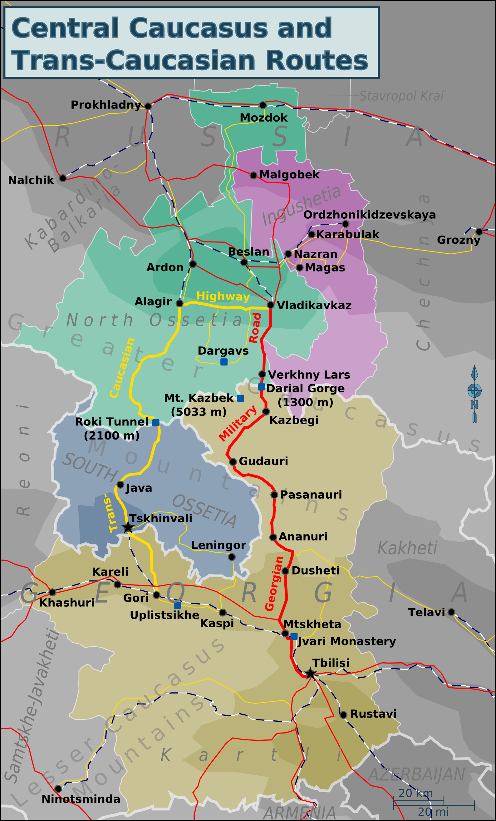
English: Map of Ingushetia, North & South Ossetia and Kartli regions for use on Wikivoyage.
SVG source File:Central Caucasus.svg Based on maps from http://www.openstreetmap.org |
| Date | |
| Source | Own work |
| Author | Travelpleb |
Licensing
edit
I, the copyright holder of this work, hereby publish it under the following license:
This file is licensed under the Creative Commons Attribution-Share Alike 3.0 Unported license.
- You are free:
- to share – to copy, distribute and transmit the work
- to remix – to adapt the work
- Under the following conditions:
- attribution – You must give appropriate credit, provide a link to the license, and indicate if changes were made. You may do so in any reasonable manner, but not in any way that suggests the licensor endorses you or your use.
- share alike – If you remix, transform, or build upon the material, you must distribute your contributions under the same or compatible license as the original.
File history
Click on a date/time to view the file as it appeared at that time.
| Date/Time | Thumbnail | Dimensions | User | Comment | |
|---|---|---|---|---|---|
| current | 17:26, 15 January 2014 | | 1,589 × 2,628 (1 MB) | Dag13 (talk | contribs) | Between North Ossetia and Russia arent any borders (deted facto). On wikivoyage are important thrue de facto borders that must be show and separated from de jure borders. |
| 17:06, 15 January 2014 |  | 1,589 × 2,628 (990 KB) | Giorgi Balakhadze (talk | contribs) | Yes borders are very important that's why I do this. Tskhinvali Region (South Ossetia) must have border same as North Ossetia has with rest of Russia, or little different, but not the same as Georgian-Russian. Reverted to version as of 21:55, 14 Januar... | |
| 23:24, 14 January 2014 |  | 1,589 × 2,628 (1 MB) | Chipmunkdavis (talk | contribs) | Reverted to version as of 21:44, 14 January 2014. Description states is for use on Wikivoyage. The border is very important for wikivoyage purposes. | |
| 21:55, 14 January 2014 |  | 1,589 × 2,628 (990 KB) | Giorgi Balakhadze (talk | contribs) | Can't be available because, borders between sovereign states do not equal to border between conflict region. Reverted to version as of 21:08, 14 January 2014 | |
| 21:44, 14 January 2014 |  | 1,589 × 2,628 (1 MB) | Dag13 (talk | contribs) | Both versions are avaible, but author write South Ossetia and make borders. These isnt important resont to change it. | |
| 21:08, 14 January 2014 |  | 1,589 × 2,628 (990 KB) | Giorgi Balakhadze (talk | contribs) | Insider reverting without explanation. Reverted to version as of 10:23, 13 January 2014 | |
| 11:11, 13 January 2014 |  | 1,589 × 2,628 (1 MB) | Insider (talk | contribs) | Reverted to version as of 18:52, 10 January 2014 | |
| 10:23, 13 January 2014 |  | 1,589 × 2,628 (990 KB) | Giorgi Balakhadze (talk | contribs) | Correction of borders, please follow NPOV. Reverted to version as of 17:00, 10 January 2014 | |
| 18:52, 10 January 2014 |  | 1,589 × 2,628 (1 MB) | Fry1989 (talk | contribs) | Reverted to version as of 17:06, 9 January 2014 | |
| 17:00, 10 January 2014 |  | 1,589 × 2,628 (990 KB) | Giorgi Balakhadze (talk | contribs) | Reverted to version as of 14:10, 9 January 2014 |
You cannot overwrite this file.
File usage on Commons
The following 2 pages use this file:
File usage on other wikis
The following other wikis use this file:
- Usage on bn.wikivoyage.org
- Usage on ca.wikipedia.org
- Usage on el.wikivoyage.org
- Usage on en.wikipedia.org
- Usage on en.wikivoyage.org
- Usage on fr.wikipedia.org
- Usage on fr.wikivoyage.org
- Usage on incubator.wikimedia.org
- Usage on it.wikivoyage.org
- Usage on ja.wikipedia.org
- Usage on ru.wikivoyage.org
- Usage on uk.wikipedia.org
- Usage on vi.wikivoyage.org
- Usage on www.wikidata.org
- Usage on zh.wikipedia.org
- Usage on zh.wikivoyage.org