File:Map at amstetten.png
No higher resolution available.
Map_at_amstetten.png (400 × 240 pixels, file size: 3 KB, MIME type: image/png)
Captions
Captions
Add a one-line explanation of what this file represents
| Description |
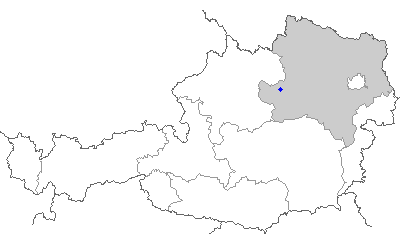
English: Map of Austria, position of the location
Deutsch: Karte von Österreich, Position der Gemeinde
Français : Carte de l'Autriche, position de la commune
Español: Mapa de Austria, posición de la ciudad
Italiano: Mappa dell'Austria, posizione del comune
Русский: Карта Автралии, местоположение данной локации. |
||
| Source | http://www.innweb.at/map/ | ||
| Author | Data collected and hosted from: Niko Hofinger | ||
| Permission (Reusing this file) |
|

File history
Click on a date/time to view the file as it appeared at that time.
| Date/Time | Thumbnail | Dimensions | User | Comment | |
|---|---|---|---|---|---|
| current | 15:16, 15 January 2006 | | 400 × 240 (3 KB) | Schaengel89~commonswiki (talk | contribs) | {{map-Austria-GNU}} |
You cannot overwrite this file.
File usage on Commons
There are no pages that use this file.
File usage on other wikis
The following other wikis use this file:
- Usage on ast.wikipedia.org
- Usage on da.wikipedia.org
- Usage on en.wikinews.org
- Usage on es.wikipedia.org
- Usage on fa.wikipedia.org
- Usage on fi.wikipedia.org
- Usage on fr.wikipedia.org
- Usage on hu.wikipedia.org
- Usage on hy.wikipedia.org
- Usage on id.wikipedia.org
- Usage on it.wikipedia.org
- Usage on ja.wikipedia.org
- Usage on mdf.wikipedia.org
- Usage on nl.wikipedia.org
- Usage on no.wikipedia.org
- Usage on pl.wikivoyage.org
- Usage on sv.wikipedia.org
- Usage on tr.wikipedia.org
- Usage on uk.wikipedia.org
- Usage on vi.wikipedia.org
- Usage on war.wikipedia.org