File:Oder-neisse.gif
Size of this preview: 800 × 518 pixels. Other resolutions: 320 × 207 pixels | 640 × 414 pixels | 827 × 535 pixels.
Original file (827 × 535 pixels, file size: 25 KB, MIME type: image/gif)
Captions
Captions
Add a one-line explanation of what this file represents

|
This map has been uploaded by Electionworld from en.wikipedia.org to enable the |
Summary
edit

|
This historical map image could be re-created using vector graphics as an SVG file. This has several advantages; see Commons:Media for cleanup for more information. If an SVG form of this image is available, please upload it and afterwards replace this template with
{{vector version available|new image name}}.
It is recommended to name the SVG file “Oder-neisse.svg”—then the template Vector version available (or Vva) does not need the new image name parameter. |
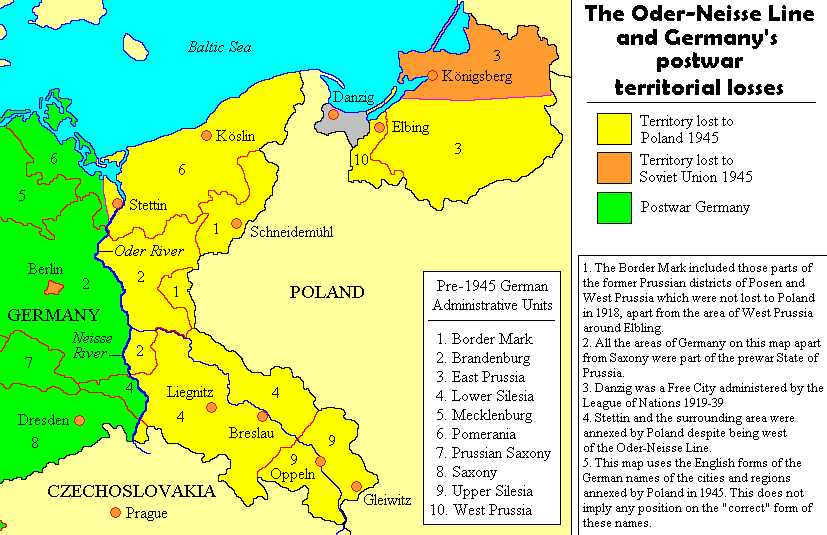
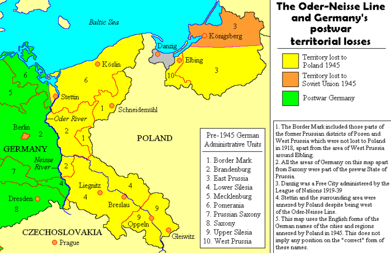
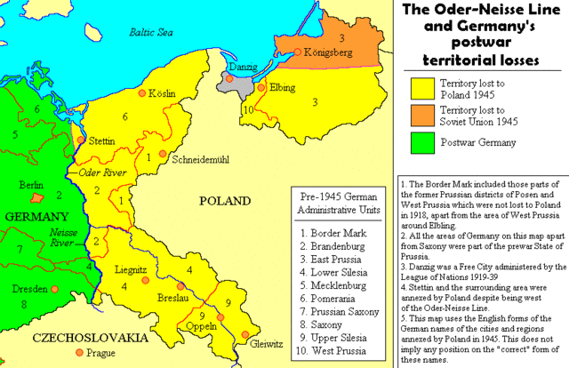
Map by User:Adam Carr, August 2006
Licensing
edit
I, the copyright holder of this work, hereby publish it under the following licenses:

|
Permission is granted to copy, distribute and/or modify this document under the terms of the GNU Free Documentation License, Version 1.2 or any later version published by the Free Software Foundation; with no Invariant Sections, no Front-Cover Texts, and no Back-Cover Texts. A copy of the license is included in the section entitled GNU Free Documentation License. |
| This file is licensed under the Creative Commons Attribution-Share Alike 3.0 Unported license. | ||
| ||
| This licensing tag was added to this file as part of the GFDL licensing update. |
You may select the license of your choice.
File history
Click on a date/time to view the file as it appeared at that time.
| Date/Time | Thumbnail | Dimensions | User | Comment | |
|---|---|---|---|---|---|
| current | 22:32, 18 August 2011 | | 827 × 535 (25 KB) | Ras67 (talk | contribs) | cropped |
| 11:48, 24 July 2009 |  | 847 × 552 (28 KB) | Botaurus (talk | contribs) | korr. Elbling --> Elbing | |
| 22:27, 22 December 2006 |  | 847 × 552 (28 KB) | Electionworld (talk | contribs) | {{ew|en|Adam Carr}} == Summary == Map by User:Adam Carr, August 2006 == Licensing == {{GFDL-self}} |
You cannot overwrite this file.
File usage on Commons
The following 2 pages use this file:
File usage on other wikis
The following other wikis use this file:
- Usage on ar.wikipedia.org
- Usage on az.wikipedia.org
- Usage on ca.wikipedia.org
- Usage on cs.wikipedia.org
- Usage on cy.wikipedia.org
- Usage on da.wikipedia.org
- Usage on de.wikipedia.org
- Usage on el.wikipedia.org
- Usage on en.wikipedia.org
- Polish Corridor
- Potsdam Conference
- German reunification
- End of World War II in Europe
- Territorial changes of Poland immediately after World War II
- Reconstruction of Germany
- Demographic estimates of the flight and expulsion of Germans
- User:Adam Carr/My archive of original cartographic contributions
- Talk:Flight and expulsion of Germans (1944–1950)/Archive 8
- Territorial evolution of Germany
- Talk:Wolf's Lair
- Timeline of World War II (1945–1991)
- Recovered Territories
- Commission for the Determination of Place Names
- Oder–Neisse line
- Abolition of Prussia
- User:Chickstarr404/Gather lists/12545 – "Exorcising Hitler"
- August 1970
- Wikipedia:Reference desk/Archives/Humanities/2020 November 3
- User:Falcaorib/Germany and Prussia
- Usage on es.wikipedia.org
- Usage on fa.wikipedia.org
- Usage on fi.wikipedia.org
- Usage on fr.wikipedia.org
- Usage on fy.wikipedia.org
- Usage on gl.wikipedia.org
- Usage on it.wikipedia.org
- Usage on ja.wikipedia.org
View more global usage of this file.