File:Trans-Kalahari-Highway.jpg

Size of this preview: 665 × 599 pixels. Other resolutions: 266 × 240 pixels | 533 × 480 pixels | 852 × 768 pixels | 1,136 × 1,024 pixels | 2,201 × 1,984 pixels.
Original file (2,201 × 1,984 pixels, file size: 677 KB, MIME type: image/jpeg)
Captions
Captions
Add a one-line explanation of what this file represents
Summary
edit
| Description |
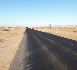
English: Trans-Kalahari-Highway (B2) near Arandis, Namibia
Deutsch: Trans-Kalahari-Highway (B2) nahe Arandis, Namibia |
| Date | |
| Source | Own work |
| Author | Jedesto |
| Permission (Reusing this file) |
All my media are licensed under CreativeCommons (CC). You may use this file free of charge, naming the author and license. However, if you want to use this file, I would be happy to receive a short message from you. It is not allowed to use this media without naming the author or without naming the license. |
| Camera location | | View this and other nearby images on: OpenStreetMap |
|---|
Licensing
edit
I, the copyright holder of this work, hereby publish it under the following license:
This file is licensed under the Creative Commons Attribution-Share Alike 4.0 International license.
- You are free:
- to share – to copy, distribute and transmit the work
- to remix – to adapt the work
- Under the following conditions:
- attribution – You must give appropriate credit, provide a link to the license, and indicate if changes were made. You may do so in any reasonable manner, but not in any way that suggests the licensor endorses you or your use.
- share alike – If you remix, transform, or build upon the material, you must distribute your contributions under the same or compatible license as the original.
File history
Click on a date/time to view the file as it appeared at that time.
| Date/Time | Thumbnail | Dimensions | User | Comment | |
|---|---|---|---|---|---|
| current | 18:25, 8 October 2018 | | 2,201 × 1,984 (677 KB) | Jedesto (talk | contribs) | User created page with UploadWizard |
You cannot overwrite this file.
File usage on Commons
There are no pages that use this file.
File usage on other wikis
The following other wikis use this file:
- Usage on de.wikipedia.org
- Usage on uk.wikipedia.org