File:Finno-ugrian-map-ukr.svg

Size of this PNG preview of this SVG file: 585 × 600 pixels. Other resolutions: 234 × 240 pixels | 468 × 480 pixels | 749 × 768 pixels | 999 × 1,024 pixels | 1,998 × 2,048 pixels | 963 × 987 pixels.
Original file (SVG file, nominally 963 × 987 pixels, file size: 927 KB)
Captions
Captions
Add a one-line explanation of what this file represents
Summary
edit
| Description |
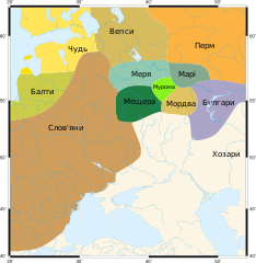
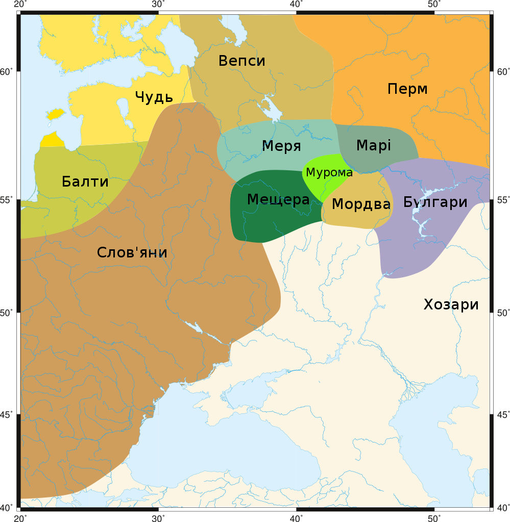
Українська: Народи Роської рівнини на рубежі 1-2 тисячоліть нашої ери |
| Date | |
| Source | |
| Author |
|
| Other versions |
.svg)
Licensing
edit
I, the copyright holder of this work, hereby publish it under the following licenses:
| This file is licensed under the Creative Commons Attribution-Share Alike 3.0 Unported license. | ||
| ||
| This licensing tag was added to this file as part of the GFDL licensing update. |

|
Permission is granted to copy, distribute and/or modify this document under the terms of the GNU Free Documentation License, Version 1.2 or any later version published by the Free Software Foundation; with no Invariant Sections, no Front-Cover Texts, and no Back-Cover Texts. A copy of the license is included in the section entitled GNU Free Documentation License. |
You may select the license of your choice.
| This is a retouched picture, which means that it has been digitally altered from its original version. Modifications: SVGized. The original can be viewed here: Finno-ugrian-map.png: File:Finno-ugrian-map.png. Modifications made by Urutseg.
|
Original upload log
edit
This image is a derivative work of the following images:
- File:Finno-ugrian-map.png licensed with Cc-by-sa-3.0-migrated, GFDL
- 2008-04-21T08:11:23Z Chesnok 610x622 (55648 Bytes) Rybinsk reservoir was builded in XX century!
- 2008-01-24T22:08:30Z Chesnok 610x622 (140466 Bytes) == Summary == From en-wiki by [http://en.wikipedia.org/wiki/User:Wiglaf Wiglaf]; russified by [User:Chesnok|Chesnok] == Licensing == {{GFDL}} {{to SVG}} [[Category:Maps of the history of Russia]] [[Category:Maps of the hi
Uploaded with derivativeFX
File history
Click on a date/time to view the file as it appeared at that time.
| Date/Time | Thumbnail | Dimensions | User | Comment | |
|---|---|---|---|---|---|
| current | 23:33, 30 November 2017 | | 963 × 987 (927 KB) | Vity OKM (talk | contribs) | User created page with UploadWizard |
You cannot overwrite this file.
File usage on Commons
The following 2 pages use this file:
File usage on other wikis
The following other wikis use this file:
- Usage on uk.wikipedia.org