File:MarethMap1943 en.png
No higher resolution available.
MarethMap1943_en.png (800 × 572 pixels, file size: 176 KB, MIME type: image/png)
Captions
Captions
Add a one-line explanation of what this file represents
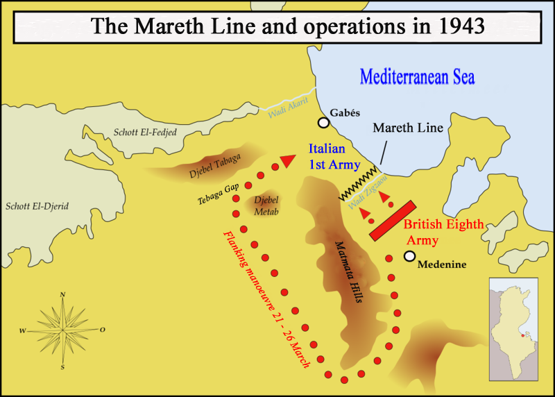
| Description | Map showing the situation of the Mareth line and the British attacks on it during March 1943 |
| Date | (UTC) |
| Source | |
| Author |
|
| This is a retouched picture, which means that it has been digitally altered from its original version. Modifications: Translated into English. The original can be viewed here: MarethMap1943.png:
|
I, the copyright holder of this work, hereby publish it under the following licenses:
This file is licensed under the Creative Commons Attribution-Share Alike 3.0 Unported, 2.5 Generic, 2.0 Generic and 1.0 Generic license.
- You are free:
- to share – to copy, distribute and transmit the work
- to remix – to adapt the work
- Under the following conditions:
- attribution – You must give appropriate credit, provide a link to the license, and indicate if changes were made. You may do so in any reasonable manner, but not in any way that suggests the licensor endorses you or your use.
- share alike – If you remix, transform, or build upon the material, you must distribute your contributions under the same or compatible license as the original.

|
Permission is granted to copy, distribute and/or modify this document under the terms of the GNU Free Documentation License, Version 1.2 or any later version published by the Free Software Foundation; with no Invariant Sections, no Front-Cover Texts, and no Back-Cover Texts. A copy of the license is included in the section entitled GNU Free Documentation License. |
You may select the license of your choice.
Original upload log
edit
This image is a derivative work of the following images:
- File:MarethMap1943.png licensed with Cc-by-sa-3.0,2.5,2.0,1.0, GFDL
- 2008-03-27T12:02:04Z Memnon335bc 1170x836 (241163 Bytes) {{Information |Description=Map showing the situation of the Mareth line and the Brith attacks on it during March 1943 |Source=self-made |Date=March 2008 |Author= [[User:Memnon335bc|Memnon335bc]] |Permission=granted |other_ver
- 2008-03-27T10:56:41Z Memnon335bc 1170x836 (239949 Bytes) {{Information |Description=Map showing the situation of the Mareth line and the Brith attacks on it during March 1943 |Source=self-made |Date=March 2008 |Author= [[User:Memnon335bc|Memnon335bc]] |Permission=granted |other_ver
Uploaded with derivativeFX
File history
Click on a date/time to view the file as it appeared at that time.
| Date/Time | Thumbnail | Dimensions | User | Comment | |
|---|---|---|---|---|---|
| current | 15:53, 9 August 2009 | | 800 × 572 (176 KB) | Kirrages (talk | contribs) | {{Information |Description=Map showing the situation of the Mareth line and the British attacks on it during March 1943 |Source=*File:MarethMap1943.png |Date=2009-08-09 15:50 (UTC) |Author=*File:MarethMap1943.png: [[User:Memnon335bc|Memnon335b |
You cannot overwrite this file.
File usage on Commons
There are no pages that use this file.
File usage on other wikis
The following other wikis use this file:
- Usage on ca.wikipedia.org
- Usage on da.wikipedia.org
- Usage on en.wikipedia.org
- Usage on es.wikipedia.org
- Usage on fi.wikipedia.org
- Usage on fr.wikipedia.org
- Usage on it.wikipedia.org
- Usage on ms.wikipedia.org
- Usage on pl.wikipedia.org
- Usage on pt.wikipedia.org
- Usage on ro.wikipedia.org
- Usage on sr.wikipedia.org
- Usage on uk.wikipedia.org
- Usage on zh.wikipedia.org