File:Ruhrpocket.png

Size of this preview: 714 × 600 pixels. Other resolutions: 286 × 240 pixels | 572 × 480 pixels | 780 × 655 pixels.
Original file (780 × 655 pixels, file size: 129 KB, MIME type: image/png)
Captions
Captions
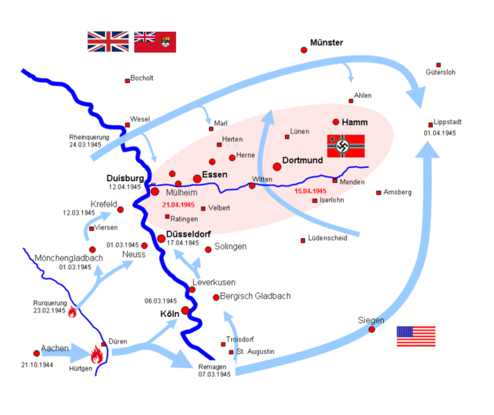
Allied establishing Ruhrpocket in late March 1945
| Description |
Deutsch: Ruhrkessel Français : Carte de la Poche de la Ruhr English: Map of the Ruhr Pocket |
| Date | 5 January 2005 (original upload date) |
| Source | Transferred from de.wikipedia to Commons. |
| Author | Kernec at German Wikipedia |
Licensing
edit
Kernec at the German-language Wikipedia, the copyright holder of this work, hereby publishes it under the following license:

|
Permission is granted to copy, distribute and/or modify this document under the terms of the GNU Free Documentation License, Version 1.2 or any later version published by the Free Software Foundation; with no Invariant Sections, no Front-Cover Texts, and no Back-Cover Texts. A copy of the license is included in the section entitled GNU Free Documentation License. |
| This file is licensed under the Creative Commons Attribution-Share Alike 3.0 Unported license. | ||
| Attribution: Kernec | ||
| ||
| This licensing tag was added to this file as part of the GFDL licensing update. |
Original upload log
edit
The original description page was here. All following user names refer to de.wikipedia.
- 2007-01-27 17:32 Hunter S. Thompson 960×720× (64270 bytes) Auf eine alte Version zurückgesetzt
- 2006-05-09 21:37 Spacefalcon 960×720× (64281 bytes) Auf eine alte Version zurückgesetzt
- 2005-01-05 22:38 Kernec 960×720× (64270 bytes) Ruhrkessel
- 2005-01-05 22:35 Kernec 960×720× (64281 bytes) Ruhrkessel
- 2005-01-05 22:20 Kernec 960×720× (64278 bytes) Ruhrkessel
| Annotations | This image is annotated: View the annotations at Commons |
File history
Click on a date/time to view the file as it appeared at that time.
| Date/Time | Thumbnail | Dimensions | User | Comment | |
|---|---|---|---|---|---|
| current | 20:38, 6 October 2017 | | 780 × 655 (129 KB) | Spazzo (talk | contribs) | Position Duisburg corrected. |
| 12:28, 15 May 2013 |  | 780 × 655 (121 KB) | Prof. Heizer~commonswiki (talk | contribs) | Changed flag of Canada to the Red Ensign in use at the time of WWII. | |
| 15:34, 5 January 2009 |  | 960 × 720 (63 KB) | TCY (talk | contribs) | {{Information |Description={{fr|Carte de la Poche de la Ruhr}} |Source=from deustche wikipedia de:Datei:Ruhrpocket.png |Date=unknown |Author=unknown |Permission= |other_versions= }} {{GFDL}} Category:WW2 Battlefront Atlas |
You cannot overwrite this file.
File usage on Commons
The following page uses this file:
File usage on other wikis
The following other wikis use this file:
- Usage on da.wikipedia.org
- Usage on de.wikipedia.org
- Usage on en.wikipedia.org
- Usage on fr.wikipedia.org
- Usage on he.wikipedia.org
- Usage on it.wikipedia.org
- Usage on ko.wikipedia.org
- Usage on nl.wikipedia.org
- Usage on no.wikipedia.org
- Usage on pl.wikipedia.org
- Usage on ru.wikipedia.org
- Usage on uk.wikipedia.org
- Usage on zh.wikipedia.org