File:Smith-Island-Map-2010.jpg
Size of this preview: 716 × 599 pixels. Other resolutions: 287 × 240 pixels | 574 × 480 pixels | 918 × 768 pixels | 1,224 × 1,024 pixels | 2,127 × 1,780 pixels.
Original file (2,127 × 1,780 pixels, file size: 822 KB, MIME type: image/jpeg)
Captions
Captions
Add a one-line explanation of what this file represents
Summary
edit
| Description |
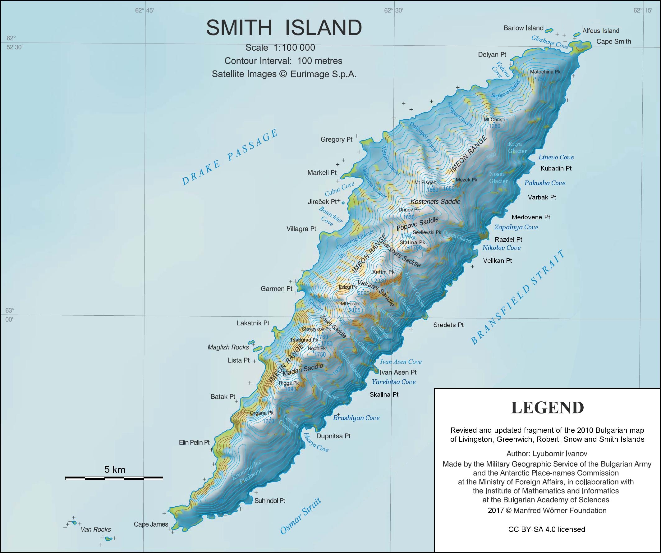
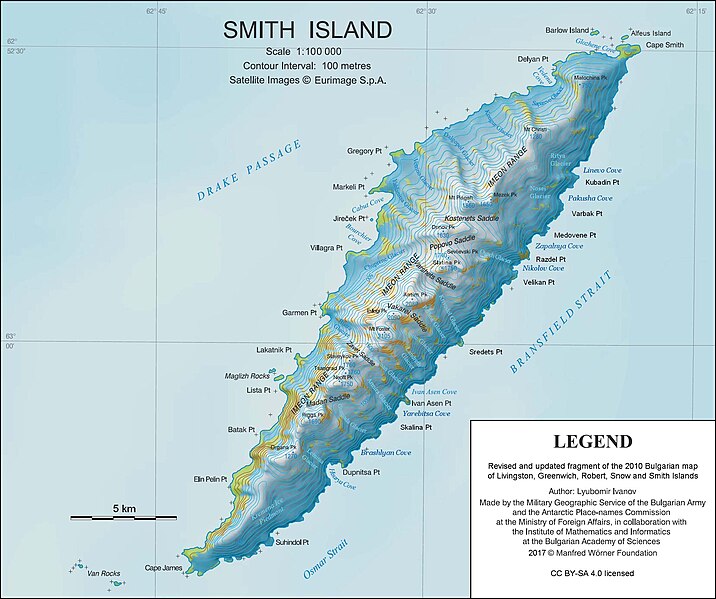
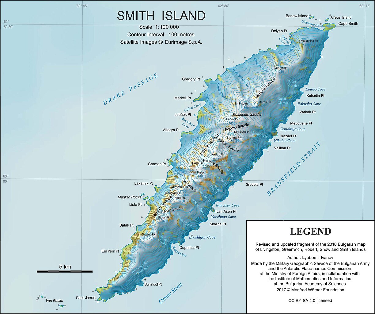
English: L.L. Ivanov. Antarctica: Smith Island. Scale 1:100000 topographic map. Manfred Wörner Foundation, 2017. Revised and updated version of the first topographic map of Smith Island, fragment of the author’s 2010 map of Livingston Island and Greenwich, Robert, Snow and Smith Islands. |
| Date | |
| Source | Own work |
| Author | Apcbg |
| Other versions | Fragment of the Commons file File:Livingston-Island-Map-2010.jpg |
| Camera location | | View this and other nearby images on: OpenStreetMap |
|---|
Licensing
edit
I, the copyright holder of this work, hereby publish it under the following license:
This file is licensed under the Creative Commons Attribution-Share Alike 4.0 International license.
- You are free:
- to share – to copy, distribute and transmit the work
- to remix – to adapt the work
- Under the following conditions:
- attribution – You must give appropriate credit, provide a link to the license, and indicate if changes were made. You may do so in any reasonable manner, but not in any way that suggests the licensor endorses you or your use.
- share alike – If you remix, transform, or build upon the material, you must distribute your contributions under the same or compatible license as the original.
Published by the Manfred Wörner Foundation, and hereby released by the Foundation’s President and CEO Apcbg (Lyubomir Ivanov) for publication under the Creative Commons Attribution ShareAlike 4.0 license.
File history
Click on a date/time to view the file as it appeared at that time.
| Date/Time | Thumbnail | Dimensions | User | Comment | |
|---|---|---|---|---|---|
| current | 12:20, 21 August 2018 | | 2,127 × 1,780 (822 KB) | Apcbg (talk | contribs) | Update |
| 11:23, 31 March 2017 |  | 2,127 × 1,780 (382 KB) | Apcbg (talk | contribs) | Update | |
| 19:28, 12 March 2017 |  | 2,127 × 1,780 (1.17 MB) | Apcbg (talk | contribs) | Update | |
| 15:50, 15 November 2016 |  | 1,465 × 1,227 (600 KB) | Apcbg (talk | contribs) | + scale | |
| 08:42, 15 November 2016 |  | 1,465 × 1,227 (596 KB) | Apcbg (talk | contribs) | Toponymy updated per SCAR Composite Gazetteer of Antarctica | |
| 17:25, 13 November 2016 |  | 1,465 × 1,227 (627 KB) | Apcbg (talk | contribs) | User created page with UploadWizard |
You cannot overwrite this file.
File usage on Commons
The following 3 pages use this file:
File usage on other wikis
The following other wikis use this file:
- Usage on ar.wikipedia.org
- Usage on bg.wikipedia.org
- Usage on ceb.wikipedia.org
- Usage on de.wikipedia.org
- Smith Island (Südliche Shetlandinseln)
- Mount Foster
- Mount Christi
- Mount Pisgah (Südliche Shetlandinseln)
- Kap Smith
- Gregory Point
- Kap James
- Van Rocks
- Wikipedia:Fragen zur Wikipedia/Archiv/2018/Woche 41
- Antim Peak
- Matochina Peak
- Mezek Peak
- Drinov Peak
- Slatina Peak
- Sevlievski Peak
- Evlogi Peak
- Slaveykov Peak
- Neofit Peak
- Tsarigrad Peak
- Riggs Peak
- Organa Peak
- Saparewo-Gletscher
- Dalgopol-Gletscher
- Owetsch-Gletscher
- Wetrino-Gletscher
- Jablaniza-Gletscher
- Tschuprene-Gletscher
- Kriwodol-Gletscher
- Rupite-Gletscher
- Armira-Gletscher
- Bistra-Gletscher
- Kongur-Gletscher
- Ritja-Gletscher
- Nosei-Gletscher
- Pashuk-Gletscher
- Landreth-Gletscher
- Dragoman-Gletscher
View more global usage of this file.