File:Karte Bahnstrecke Medina–Mekka.png
Size of this preview: 458 × 600 pixels. Other resolutions: 183 × 240 pixels | 367 × 480 pixels | 586 × 768 pixels | 782 × 1,024 pixels | 2,474 × 3,239 pixels.
Original file (2,474 × 3,239 pixels, file size: 5.17 MB, MIME type: image/png)
Captions
Captions
Add a one-line explanation of what this file represents
Summary
edit
| Description |
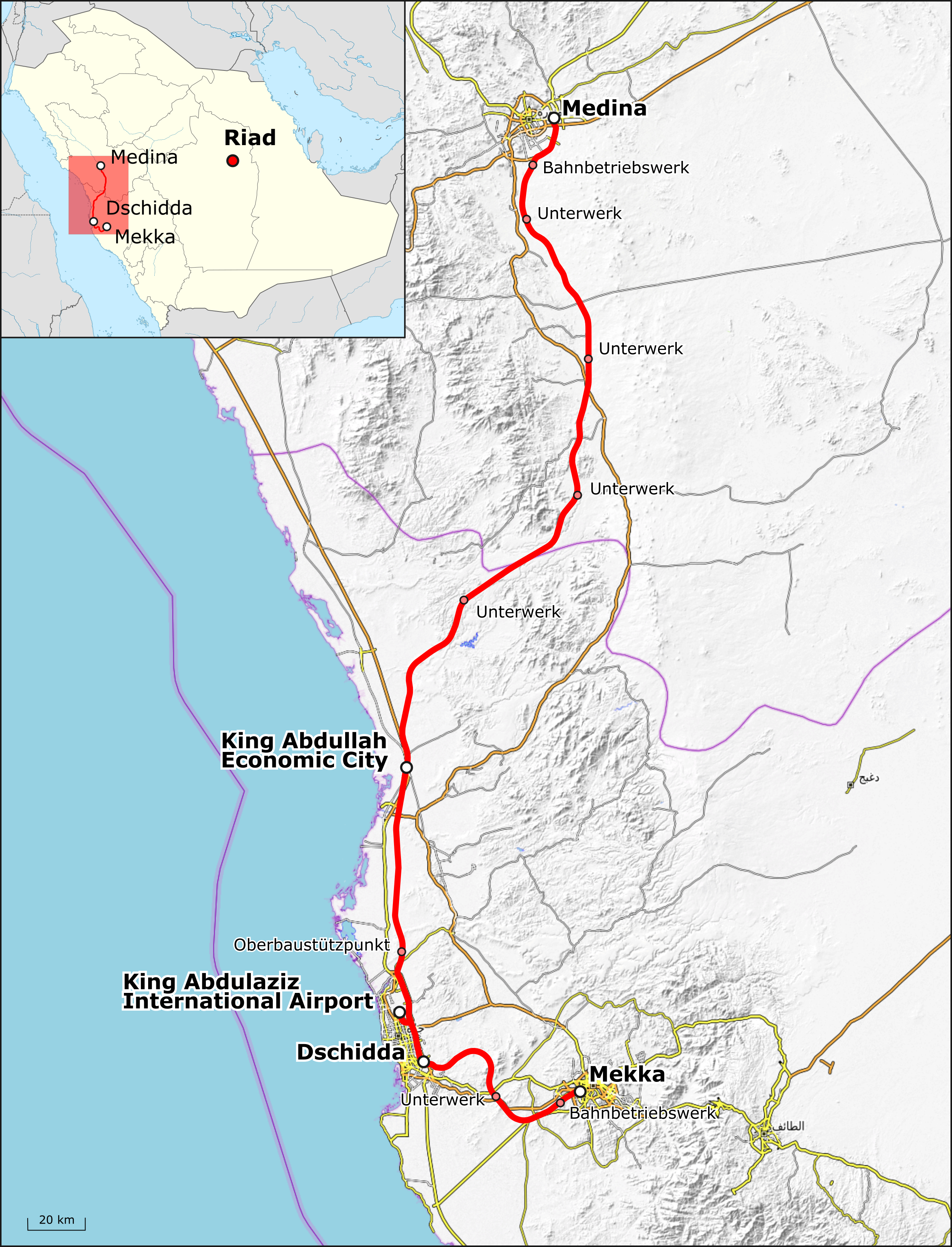
English: Map of Haramain High Speed Rail Project. Index in German
Deutsch: Karte der Bahnstrecke Medina–Mekka |
|||||||||
| Date | ||||||||||
| Source |
Map was created using:
|
|||||||||
| Creator |
|
|||||||||
| Permission (Reusing this file) |
|
|||||||||
| Geotemporal data | ||||||||||
| Bounding box |
|
|||||||||
| Georeferencing | ||||||||||
| Other versions |
Englische Beschriftung:  |
|||||||||
Licensing
edit
I, the copyright holder of this work, hereby publish it under the following license:
This file is licensed under the Creative Commons Attribution-Share Alike 3.0 Unported license.
Attribution: Peter Christener
- You are free:
- to share – to copy, distribute and transmit the work
- to remix – to adapt the work
- Under the following conditions:
- attribution – You must give appropriate credit, provide a link to the license, and indicate if changes were made. You may do so in any reasonable manner, but not in any way that suggests the licensor endorses you or your use.
- share alike – If you remix, transform, or build upon the material, you must distribute your contributions under the same or compatible license as the original.
| This work is licensed under the Open Database License (summary). |
File history
Click on a date/time to view the file as it appeared at that time.
| Date/Time | Thumbnail | Dimensions | User | Comment | |
|---|---|---|---|---|---|
| current | 16:36, 16 November 2017 | | 2,474 × 3,239 (5.17 MB) | Pechristener (talk | contribs) | location map added |
| 16:06, 16 November 2017 |  | 2,474 × 3,239 (5.4 MB) | Pechristener (talk | contribs) | == {{int:filedesc}} == {{Map |Description={{en|1=Map of {{w|Haramain High Speed Rail Project}}. Index in German}} {{de|1=Karte der {{w|Bahnstrecke Medina–Mekka||de}}}} |Source= Map was created using: *[http://www.openstreetmap.org/ Open Street Map]... |
You cannot overwrite this file.
File usage on Commons
The following 7 pages use this file:
- User:Chumwa/OgreBot/Potential transport maps/2017 November 11-20
- User:Chumwa/OgreBot/Public transport information/2017 November 11-20
- User:Chumwa/OgreBot/Transport Maps/2017 November 11-20
- User:Chumwa/OgreBot/Travel and communication maps/2017 November 11-20
- User talk:Pechristener/archives 1
- File:Haramain high-speed railway.png
- Category:Haramain high-speed rail project
File usage on other wikis
The following other wikis use this file:
- Usage on ar.wikipedia.org
- Usage on de.wikipedia.org
- Usage on en.wikipedia.org
- Usage on es.wikipedia.org
- Usage on fa.wikipedia.org
- Usage on fr.wikipedia.org
- Usage on ha.wikipedia.org
- Usage on hu.wikipedia.org
- Usage on id.wikipedia.org
- Usage on ja.wikipedia.org
- Usage on ml.wikipedia.org
- Usage on ms.wikipedia.org
- Usage on pnb.wikipedia.org
- Usage on ru.wikipedia.org
- Usage on tr.wikipedia.org
- Usage on uk.wikipedia.org
- Usage on ur.wikipedia.org
- Usage on www.wikidata.org