File:Franklin 2005 track.png
Size of this preview: 800 × 578 pixels. Other resolutions: 320 × 231 pixels | 640 × 462 pixels | 1,024 × 740 pixels | 1,280 × 924 pixels | 2,700 × 1,950 pixels.
Original file (2,700 × 1,950 pixels, file size: 2.39 MB, MIME type: image/png)
Captions
Captions
Add a one-line explanation of what this file represents
Summary
| Description |
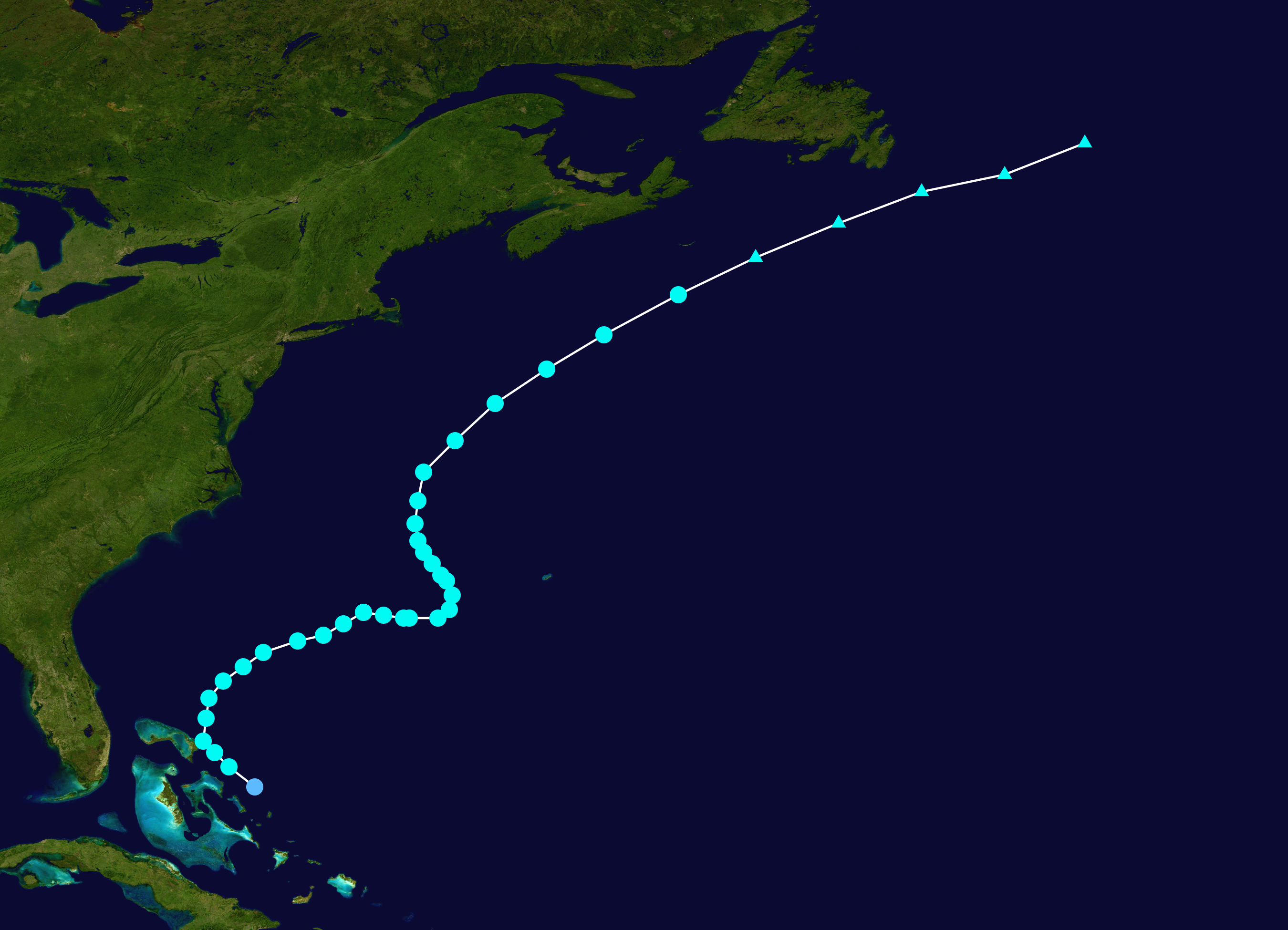
English: Track map of Tropical Storm Franklin of the 2005 Atlantic hurricane season. The points show the location of the storm at 6-hour intervals. The colour represents the storm's maximum sustained wind speeds as classified in the (see below), and the shape of the data points represent the nature of the storm, according to the legend below. Tropical depression (≤38 mph, ≤62 km/h)
Tropical storm (39–73 mph, 63–118 km/h)
Category 1 (74–95 mph, 119–153 km/h)
Category 2 (96–110 mph, 154–177 km/h)
Category 3 (111–129 mph, 178–208 km/h)
Category 4 (130–156 mph, 209–251 km/h)
Category 5 (≥157 mph, ≥252 km/h)
Unknown
Storm type |
||
| Date | 2005-07-21–2005-07-31 | ||
| Source | Created by Supportstorm using Wikipedia:WikiProject Tropical cyclones/Tracks. The background image is from NASA. Tracking data is from the National Hurricane Center[1]. | ||
| Author | Supportstorm | ||
| Source code | Track map data table, if present below, is in HURDAT2 or ATCF format. See format details in [2] and [3], respectively.
|
Licensing
edit| This work has been released into the public domain by its author, Supportstorm. This applies worldwide. In some countries this may not be legally possible; if so: Supportstorm grants anyone the right to use this work for any purpose, without any conditions, unless such conditions are required by law. |
File history
Click on a date/time to view the file as it appeared at that time.
| Date/Time | Thumbnail | Dimensions | User | Comment | |
|---|---|---|---|---|---|
| current | 16:41, 28 November 2019 | | 2,700 × 1,950 (2.39 MB) | Supportstorm (talk | contribs) | 2700 px |
| 18:06, 27 August 2010 |  | 1,024 × 740 (395 KB) | Iune (talk | contribs) | full track | |
| 22:57, 12 July 2006 |  | 1,024 × 633 (399 KB) | Nilfanion (talk | contribs) | ||
| 18:46, 10 July 2006 |  | 1,024 × 633 (398 KB) | Nilfanion (talk | contribs) | {{Hurricane auto track map|Tropical Storm Franklin (2005)}} | |
| 00:44, 28 March 2006 |  | 1,024 × 633 (399 KB) | Jdorje~commonswiki (talk | contribs) | {{Hurricane auto track map|Tropical Storm Franklin (2005)}} | |
| 04:50, 14 November 2005 |  | 1,024 × 633 (381 KB) | Jdorje~commonswiki (talk | contribs) | {{Hurricane auto track map|Tropical Storm Franklin (2005)}} | |
| 07:23, 11 November 2005 |  | 1,024 × 633 (380 KB) | Jdorje~commonswiki (talk | contribs) | ||
| 01:07, 10 November 2005 |  | 1,024 × 988 (477 KB) | Jdorje~commonswiki (talk | contribs) | {{Hurricane auto track map|Tropical Storm Franklin (2005)}} Franklin Franklin Franklin |
You cannot overwrite this file.
File usage on Commons
The following 2 pages use this file:
File usage on other wikis
The following other wikis use this file:
- Usage on bn.wikipedia.org
- Usage on ca.wikipedia.org
- Usage on de.wikipedia.org
- Usage on en.wikipedia.org
- Usage on es.wikipedia.org
- Usage on eu.wikipedia.org
- Usage on fr.wikipedia.org
- Usage on hu.wikipedia.org
- Usage on pt.wikipedia.org
- Usage on simple.wikipedia.org
- Usage on sv.wikipedia.org
- Usage on uk.wikipedia.org
- Usage on www.wikidata.org
- Usage on zh.wikipedia.org