File:Ashoka Empire.png
Original file (1,060 × 924 pixels, file size: 1.22 MB, MIME type: image/png)
Captions
Captions
Summary
edit
| Description |
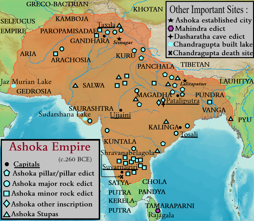
English: References:
Maximum extent of the Maurya Empire, as shown by the location of Ashoka's inscriptions, and visualized by ASI (Archeological Survey Of India),[1] modern archaeologist :Nayanjot Lahiri[2],Dougald J. W. O'Reilly,[3]old archeologist :D.R. Bhandarkar[4], Myra Shackley:[5]
https://en.m.wikipedia.org/wiki/Rajagala
ASI published book (Indian History Quaternary volume 4) https://archive.org/details/dli.calcutta.06445 " Mauryan empire towards the satrapies of Gedrosia part of which were ceded by Seleucus to Chandragupta. The discovery of the remains of a large Buddhist sanctuary on "Koh-i-Khwaja" in Sistan suggests that this province also was perhaps included in the Mauryan empire, and the Buddhist influence reached there in the time of Asoka himself." Further south, that Jaz Morian Lake have marked this side the western boundary of the Mauryan empire. As the name suggests, this place commemorates some signal victory or achievement of the Mauryan emperors. It may be the construction of the lake itself like the big Sudarsana lake by Chandragupta further east in Kathiawad"
8th line of inscription :- https://en.wikipedia.org/wiki/Junagadh_rock_inscription_of_Rudradaman |
| Date | |
| Source | Own work |
| Author | Facttez999a2z |
![[1]](./File:Ashoka_Empire.png.html#cite_note-1)
![[2]](./File:Ashoka_Empire.png.html#cite_note-NAVJOT-2)
![[3]](./File:Ashoka_Empire.png.html#cite_note-DOUGLE-3)
![[4]](./File:Ashoka_Empire.png.html#cite_note-BHANDARKAR-4)
![[5]](./File:Ashoka_Empire.png.html#cite_note-SHACKLEY-5)
Licensing
edit
- You are free:
- to share – to copy, distribute and transmit the work
- to remix – to adapt the work
- Under the following conditions:
- attribution – You must give appropriate credit, provide a link to the license, and indicate if changes were made. You may do so in any reasonable manner, but not in any way that suggests the licensor endorses you or your use.
Reference
edit
- ↑ Indian Historical Quarterly, Vol-13, Issue no.-1-4, p. 412
- ↑ " Pg.5 : In relation to his predecessors, he was the first Indian king to rule over an empire embracing much of India and its western borderlands, from Afghanistan to Orissa and towards the south as far as Karnataka. In relation to the rulers who followed him, it was his example which influenced thought-philosophical, religious, cultural-in Asia more profoundly than that of any other political figure of antiquity." Lahiri, Nayanjot (5 August 2015) (in English) Ashoka in Ancient India, Harvard University Press, p. 5 ISBN: 978-0-674-05777-7.
- ↑ " O'Reilly, Dougald J. W. (2007) (in English) Early Civilizations of Southeast Asia, Rowman Altamira, p. 178 ISBN: 978-0-7591-0279-8.
- ↑ " Pg.42-43 : We thus obtain a fairly accurate idea of the extent of Asoka's dominions. They included the whole of India except the southern extremity of the peninsula held by the Choda, Pandya, Satiya- putra and Keralaputra kings. This southern boundary is marked roughly by a line drawn from Pulicat near Madras in the east, to Gooty and Chitaldrug in the north where the four copies of Aśoka's Minor Rock Edicts have been discovered right up to the northern point of the South Canara District on the west. Let us now see what Greek princes have been mentioned by Aśoka as his contemporaries, and try to identify them. They have all been named in Rock Edict XIII. Of course, Amtiyoka is the first to be named as he was a neighbour of Asoka. Beyond his kingdom, we are told, were ruling the four princes Turamaya, Amtekina or Amtikini, Maga and Alikasumdra. Amtiyoka is, of course, Antiochus II. Theos (B.C. 261-246), king of Syria, and Turamaya, Ptolemy II. Philadelphos of Egypt (285-247). Amtekina or Amtikini, as Bühler has remarked, corresponds to the Greek Antigenes rather than to Antigonus."Bhandarkar, D. R. Asoka, Central Archelogical Library, p. 42−43 ISBN: 978-93-837-2346-1.
- ↑ " Pg.67 - After Alexanderâs retreat from the Indus the Emperor Chandragupta Maurya established the first indigenous empire to exercise control over much of the subcontinent, and eventually, under his successors, this covered all but the tip of the peninsula. Asoka, the greatest of the Mauryan emperors, took power in 272 BC and extended the empire from Afghanistan to Assam and from the Himalayas to Mysore, leaving behind a series of inscriptions recording his edicts on pillars and rocks across the continent." Shackley, Myra L.; Internet Archive (2006) Atlas of travel and tourism development, Amsterdam ; Boston : Elsevier, p. 67 ISBN: 978-0-7506-6348-9.
File history
Click on a date/time to view the file as it appeared at that time.
| Date/Time | Thumbnail | Dimensions | User | Comment | |
|---|---|---|---|---|---|
| current | 07:38, 28 March 2024 | | 1,060 × 924 (1.22 MB) | Facttez999a2z (talk | contribs) | kamboja naming |
| 09:45, 16 February 2024 |  | 1,060 × 924 (1.21 MB) | Facttez999a2z (talk | contribs) | minor improvements | |
| 11:33, 4 January 2024 |  | 1,060 × 924 (1.2 MB) | Facttez999a2z (talk | contribs) | Uploaded own work with UploadWizard |
You cannot overwrite this file.
File usage on Commons
The following 2 pages use this file:
File usage on other wikis
The following other wikis use this file:
- Usage on ast.wikipedia.org
- Usage on cs.wikipedia.org
- Usage on es.wikipedia.org
- Usage on hi.wikipedia.org
- Usage on hy.wikipedia.org
- Usage on lv.wikipedia.org
- Usage on ne.wikipedia.org
- Usage on si.wikipedia.org
- Usage on uk.wikipedia.org
- Usage on zh-classical.wikipedia.org
- Usage on zh-yue.wikipedia.org
- Usage on zh.wikipedia.org