File:Map-okinawa-pref.png

Size of this preview: 800 × 425 pixels. Other resolutions: 320 × 170 pixels | 900 × 478 pixels.
Original file (900 × 478 pixels, file size: 132 KB, MIME type: image/png)
Captions
Captions
Add a one-line explanation of what this file represents

|
This map image could be re-created using vector graphics as an SVG file. This has several advantages; see Commons:Media for cleanup for more information. If an SVG form of this image is available, please upload it and afterwards replace this template with
{{vector version available|new image name}}.
It is recommended to name the SVG file “Map-okinawa-pref.svg”—then the template Vector version available (or Vva) does not need the new image name parameter. |
Summary
edit
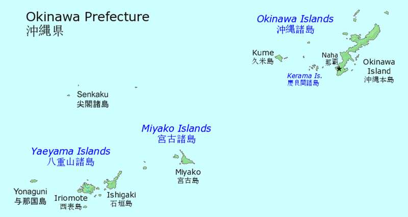
| Description | The location of islands in Okinawa. |
| Source | en:Image:Map-okinawa-pref.png |
| Author | Source is made by en:user:Jpatokal based on PD rendering from demis.nl map server. |
| Permission (Reusing this file) |
GFDL |
Licensing
edit

|
Permission is granted to copy, distribute and/or modify this document under the terms of the GNU Free Documentation License, Version 1.2 or any later version published by the Free Software Foundation; with no Invariant Sections, no Front-Cover Texts, and no Back-Cover Texts. A copy of the license is included in the section entitled GNU Free Documentation License. |
| This file is licensed under the Creative Commons Attribution-Share Alike 3.0 Unported license. | ||
| ||
| This licensing tag was added to this file as part of the GFDL licensing update. |
File history
Click on a date/time to view the file as it appeared at that time.
| Date/Time | Thumbnail | Dimensions | User | Comment | |
|---|---|---|---|---|---|
| current | 20:47, 15 August 2019 | | 900 × 478 (132 KB) | Artanisen (talk | contribs) | Increased image size with Yonaguni and Senkaku islands. |
| 00:02, 14 May 2011 |  | 702 × 400 (38 KB) | Keraunoscopia (talk | contribs) | Remove watermark | |
| 07:34, 29 August 2006 |  | 702 × 400 (41 KB) | Alberth2 (talk | contribs) | {{Information |Description= |Source=[http://en.wikipedia.org/wiki/Image:Map-okinawa-pref.png En wiki] |Permission= GFDL }} |
You cannot overwrite this file.
File usage on Commons
The following page uses this file:
File usage on other wikis
The following other wikis use this file:
- Usage on af.wikipedia.org
- Usage on az.wikipedia.org
- Usage on bs.wikipedia.org
- Usage on cs.wikipedia.org
- Usage on da.wikipedia.org
- Usage on de.wikipedia.org
- Usage on de.wikivoyage.org
- Usage on el.wikipedia.org
- Usage on en.wikipedia.org
- Usage on en.wikivoyage.org
- Usage on eo.wikipedia.org
- Usage on es.wikipedia.org
- Usage on et.wikipedia.org
- Usage on eu.wikipedia.org
- Usage on fa.wikipedia.org
- Usage on fi.wikipedia.org
- Usage on fr.wikipedia.org
- Usage on gl.wikipedia.org
- Usage on he.wikipedia.org
- Usage on hu.wikipedia.org
- Usage on id.wikipedia.org
- Usage on it.wikipedia.org
View more global usage of this file.