File:CarthageMapZh.png
CarthageMapZh.png (770 × 447 pixels, file size: 105 KB, MIME type: image/png)
Captions
Captions
Summary
edit
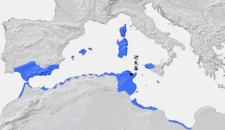
Location of Carthage and Carthaginian influence sphere before the First Punic War (264 BC)
Source: Self-made, based on Putzger Atlas und Chronik zur Weltgeschichte, Berlin, 2002
Template: [1] archive copy at the Wayback Machine
Author: BishkekRocks
Original Version is here.
The Chinese modified version is made by ItsMine.
Licensing
edit
| This work has been released into the public domain by its author, BishkekRocks. This applies worldwide. In some countries this may not be legally possible; if so: |
File history
Click on a date/time to view the file as it appeared at that time.
| Date/Time | Thumbnail | Dimensions | User | Comment | |
|---|---|---|---|---|---|
| current | 12:30, 8 April 2007 | | 770 × 447 (105 KB) | Itsmine (talk | contribs) | |
| 04:18, 10 March 2007 |  | 770 × 447 (105 KB) | Itsmine (talk | contribs) | == Summary == Location of Carthage and Carthaginian influence sphere before the First Punic War (264 BC) Source: Self-made, based on Putzger Atlas und Chronik zur Weltgeschichte, Berlin, 2002 Template: [http://www.demis.nl/wms/mapclip.htm] Author: [[Us |
You cannot overwrite this file.
File usage on Commons
The following page uses this file:
File usage on other wikis
The following other wikis use this file: