File:DominanzSchartenhoeheNew.png
Size of this preview: 487 × 600 pixels. Other resolutions: 195 × 240 pixels | 390 × 480 pixels | 624 × 768 pixels | 831 × 1,024 pixels | 1,736 × 2,138 pixels.
Original file (1,736 × 2,138 pixels, file size: 915 KB, MIME type: image/png)
Captions
Captions
Add a one-line explanation of what this file represents

|
This graph image could be re-created using vector graphics as an SVG file. This has several advantages; see Commons:Media for cleanup for more information. If an SVG form of this image is available, please upload it and afterwards replace this template with
{{vector version available|new image name}}.
It is recommended to name the SVG file “DominanzSchartenhoeheNew.svg”—then the template Vector version available (or Vva) does not need the new image name parameter. |
Summary
edit
| Description |
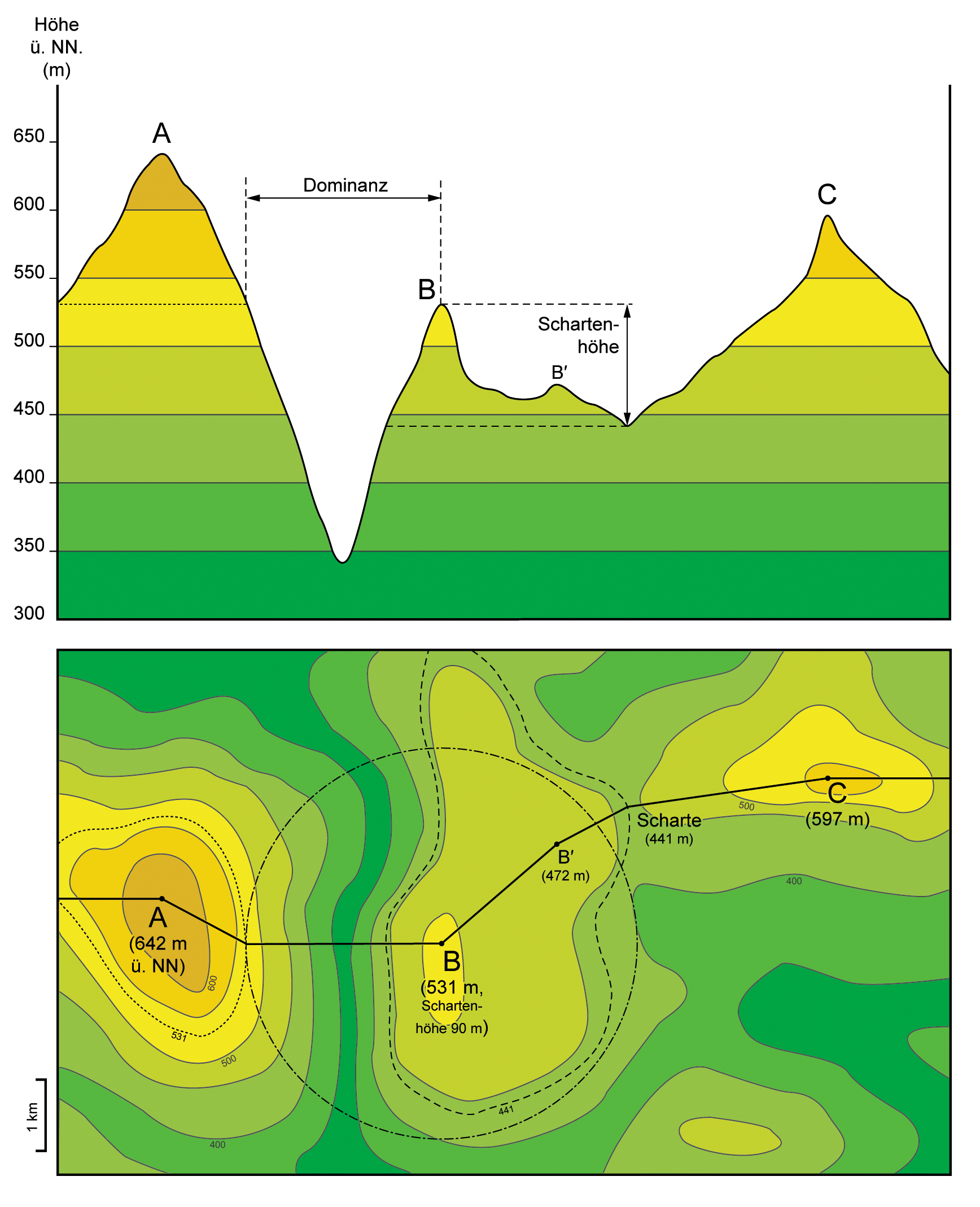
English: Top figure: Projection of terrain elevation along solid black line in the lower figure. Criteria for topographic isolation (Dominanz) and prominence (Schartenhöhe) are given for summit “B”.
Bottom figure: Corresponding topographic map. Dashed black line corresponds to the lowest contour line encircling summit “B” but no higher summit. Black dash-dot line delineates circular area of topographic isolation of summit “B”. Dotted black line corresponds to the contour line on summit “A” which is tangent to the “isolation circle” of summit “B”. Deutsch: Oben: Projektion der Topographie entlang der durchgezogenen schwarzen Linie in der unteren Abbildung. Eingezeichnet sind Dominanz und Schartenhöhe für Berg „B“. Unten: Entsprechende topographische Karte. Die gestrichelte schwarze Linie entspricht der niedrigsten Höhenlinie, die Berg „B“ einschließt aber keinen höheren Gipfel. Die schwarze Strichpunktlinie umreißt die Kreisfläche, die durch die Dominanz von Berg „B“ definiert ist. Die gepunktete schwarze Linie entspricht der Höhenlinie auf den Flanken von Berg „A“, die den „Dominanzkreis“ von Berg „B“ tangiert. |
| Date | |
| Source | Own work : fiktional example with the known definitions of the subject implemented |
| Author | Gretarsson |
Licensing
edit
I, the copyright holder of this work, hereby publish it under the following licenses:

|
Permission is granted to copy, distribute and/or modify this document under the terms of the GNU Free Documentation License, Version 1.2 or any later version published by the Free Software Foundation; with no Invariant Sections, no Front-Cover Texts, and no Back-Cover Texts. A copy of the license is included in the section entitled GNU Free Documentation License. |
This file is licensed under the Creative Commons Attribution-Share Alike 3.0 Unported, 2.5 Generic, 2.0 Generic and 1.0 Generic license.
- You are free:
- to share – to copy, distribute and transmit the work
- to remix – to adapt the work
- Under the following conditions:
- attribution – You must give appropriate credit, provide a link to the license, and indicate if changes were made. You may do so in any reasonable manner, but not in any way that suggests the licensor endorses you or your use.
- share alike – If you remix, transform, or build upon the material, you must distribute your contributions under the same or compatible license as the original.
You may select the license of your choice.
File history
Click on a date/time to view the file as it appeared at that time.
| Date/Time | Thumbnail | Dimensions | User | Comment | |
|---|---|---|---|---|---|
| current | 22:18, 27 September 2016 | | 1,736 × 2,138 (915 KB) | Cmdrjameson (talk | contribs) | Compressed with pngout. Reduced by 606kB (39% decrease). |
| 15:14, 13 November 2013 |  | 1,736 × 2,138 (1.49 MB) | Gretarsson (talk | contribs) | "Terrain profile" drawing is not based on a vertical section anymore but is mainly a projection. Topographic map in lower figure is largely altered in order to obtain a "profile" which is still similar to that of the previous image version. | |
| 17:36, 12 November 2013 |  | 1,736 × 2,077 (1.36 MB) | Gretarsson (talk | contribs) | {{Information |Description ={{en|1=Top image: Section along X-X' line in lower image. Criteria for topographic isolation (Dominanz) and prominence (Schartenhöhe) are given for summit B. Bottom image: Corresponding topographic map. Dashed black line... |
You cannot overwrite this file.
File usage on Commons
The following 2 pages use this file:
File usage on other wikis
The following other wikis use this file:
- Usage on als.wikipedia.org
- Usage on de.wikipedia.org
- Usage on es.wikibooks.org
- Usage on frr.wikipedia.org