File:Oyoxviii.jpeg
No higher resolution available.
Oyoxviii.jpeg (545 × 341 pixels, file size: 156 KB, MIME type: image/jpeg)
Captions
Captions
Add a one-line explanation of what this file represents
Summary
edit
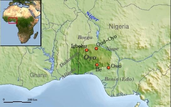
| Description | Oyo Empire and surrounding states |
| Date | |
| Source | drawing on File:Africa_topography_map_with_borders.png and File:Africa_satellite_orthographic.jpg |
| Author | Commons and Rollebon |
| Permission (Reusing this file) |
GNU for main map. For inset : " public domain because it was created by NASA. NASA copyright policy states that "NASA material is not protected by copyright unless noted", according to licence to original. Both originals are on Commons. just added names with the Gimp. |
Licensing
edit

|
Permission is granted to copy, distribute and/or modify this document under the terms of the GNU Free Documentation License, Version 1.2 or any later version published by the Free Software Foundation; with no Invariant Sections, no Front-Cover Texts, and no Back-Cover Texts. A copy of the license is included in the section entitled GNU Free Documentation License. |
| This file is licensed under the Creative Commons Attribution-Share Alike 3.0 Unported license. | ||
| ||
| This licensing tag was added to this file as part of the GFDL licensing update. |
File history
Click on a date/time to view the file as it appeared at that time.
| Date/Time | Thumbnail | Dimensions | User | Comment | |
|---|---|---|---|---|---|
| current | 20:45, 9 June 2008 | | 545 × 341 (156 KB) | Rollebon (talk | contribs) | {{Information |Description=Oyo Empire and surrounding states, with scale |Source=drawing on http://commons.wikimedia.org/wiki/Image%3AAfrica_topography_map_with_borders.png and http://commons.wikimedia.org/wiki/Image:Africa_satellite_orthographic.jpg |Dat |
| 23:03, 6 June 2008 |  | 545 × 341 (161 KB) | Rollebon (talk | contribs) | {{Information |Description=Oyo Empire and surrounding states |Source=drawing on http://commons.wikimedia.org/wiki/Image%3AAfrica_topography_map_with_borders.png and http://commons.wikimedia.org/wiki/Image:Africa_satellite_orthographic.jpg |Date=20080606 | |
You cannot overwrite this file.
File usage on Commons
The following page uses this file:
File usage on other wikis
The following other wikis use this file:
- Usage on als.wikipedia.org
- Usage on ar.wikipedia.org
- Usage on azb.wikipedia.org
- Usage on ca.wikipedia.org
- Usage on cs.wikipedia.org
- Usage on en.wikipedia.org
- Usage on es.wikipedia.org
- Usage on fr.wikipedia.org
- Usage on ha.wikipedia.org
- Usage on he.wikipedia.org
- Usage on hi.wikipedia.org
- Usage on ja.wikipedia.org
- Usage on lt.wikipedia.org
- Usage on ms.wikipedia.org
- Usage on nl.wikipedia.org
- Usage on no.wikipedia.org
- Usage on oc.wikipedia.org
- Usage on pl.wikipedia.org
- Usage on ru.wikipedia.org
- Usage on ug.wikipedia.org
- Usage on uk.wikipedia.org