File:Myanmar-CIA-map-German.png
Size of this preview: 275 × 600 pixels. Other resolution: 292 × 637 pixels.
Original file (292 × 637 pixels, file size: 16 KB, MIME type: image/png)
Captions
Captions
Add a one-line explanation of what this file represents
Summary
edit
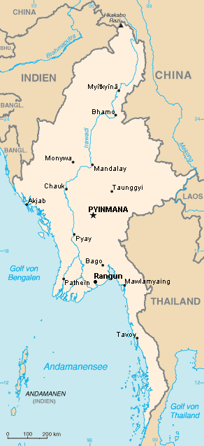
Country map of Myanmar with German names.
Made from Image:Myanmar.png
Licensing
edit
I, the copyright holder of this work, hereby publish it under the following license:

|
Permission is granted to copy, distribute and/or modify this document under the terms of the GNU Free Documentation License, Version 1.2 or any later version published by the Free Software Foundation; with no Invariant Sections, no Front-Cover Texts, and no Back-Cover Texts. A copy of the license is included in the section entitled GNU Free Documentation License. |
| This file is licensed under the Creative Commons Attribution-Share Alike 3.0 Unported license. | ||
| ||
| This licensing tag was added to this file as part of the GFDL licensing update. |
File history
Click on a date/time to view the file as it appeared at that time.
| Date/Time | Thumbnail | Dimensions | User | Comment | |
|---|---|---|---|---|---|
| current | 18:06, 10 December 2010 | | 292 × 637 (16 KB) | Ras67 (talk | contribs) | cropped and squeezed |
| 12:03, 25 January 2007 |  | 296 × 642 (25 KB) | Auchwaswisser~commonswiki (talk | contribs) | Country map of Myanmar with German names. Made from Image:Myanmar.png |
You cannot overwrite this file.
File usage on Commons
The following 2 pages use this file:
File usage on other wikis
The following other wikis use this file:
- Usage on als.wikipedia.org
- Usage on ar.wikipedia.org
- Usage on de.wikipedia.org
- Usage on sq.wikipedia.org