File:Romania Regions Transylvania.jpg
Size of this preview: 800 × 580 pixels. Other resolutions: 320 × 232 pixels | 640 × 464 pixels | 1,024 × 742 pixels | 1,280 × 927 pixels | 2,587 × 1,874 pixels.
Original file (2,587 × 1,874 pixels, file size: 2.67 MB, MIME type: image/jpeg)
Captions
Captions
Add a one-line explanation of what this file represents
Summary
edit
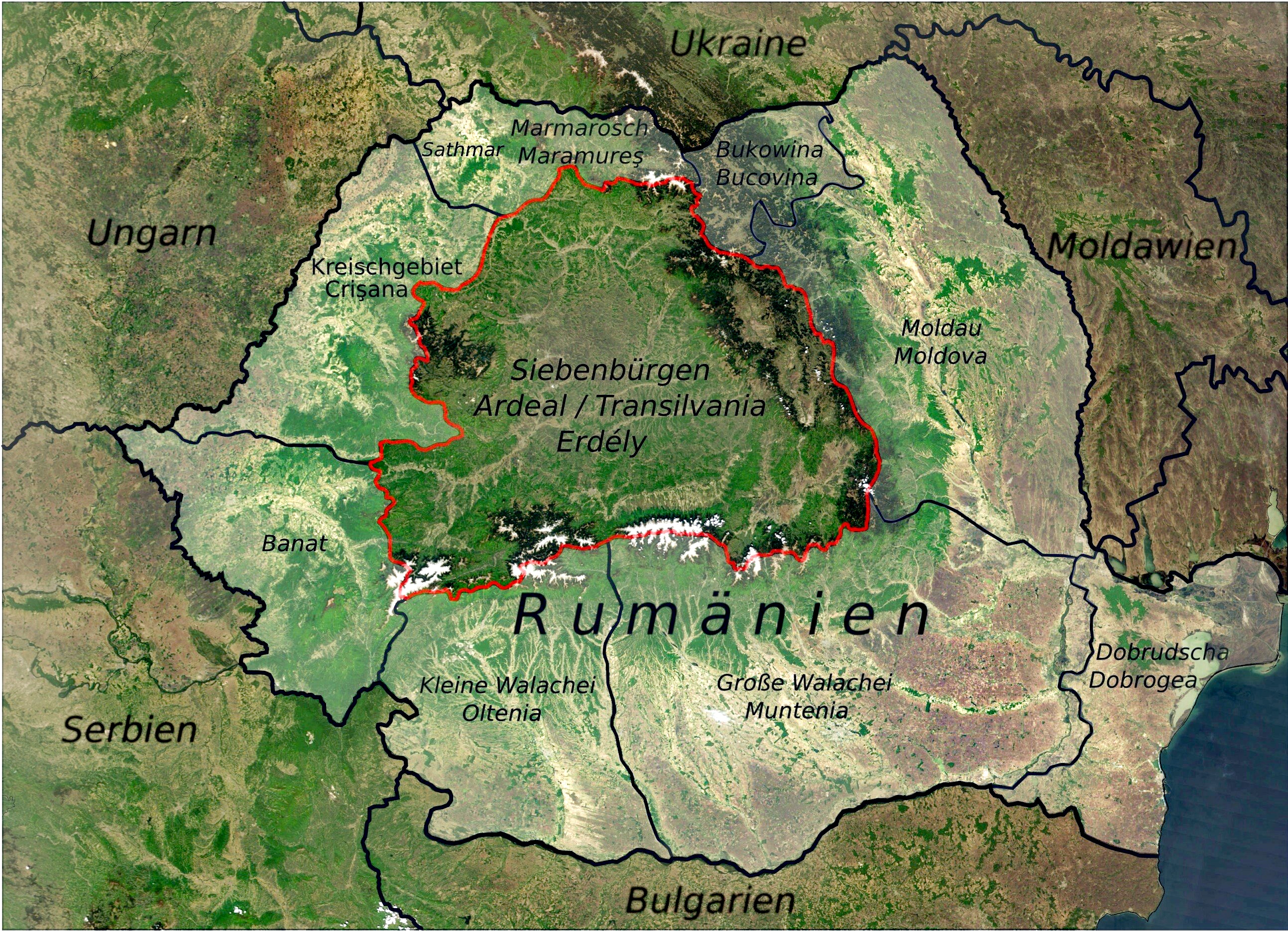
| Description | The region of (historic) Transylvania in today's Romania |
| Date | |
| Source | Own work, based on NASA Visible Earth The Carpathian Mountains. Credit: Jeff Schmaltz, MODIS Rapid Response Team, NASA/GSFC |
| Author | DietG |
Licensing
edit
I, the copyright holder of this work, hereby publish it under the following license:
This file is licensed under the Creative Commons Attribution 3.0 Unported license.
- You are free:
- to share – to copy, distribute and transmit the work
- to remix – to adapt the work
- Under the following conditions:
- attribution – You must give appropriate credit, provide a link to the license, and indicate if changes were made. You may do so in any reasonable manner, but not in any way that suggests the licensor endorses you or your use.
File history
Click on a date/time to view the file as it appeared at that time.
| Date/Time | Thumbnail | Dimensions | User | Comment | |
|---|---|---|---|---|---|
| current | 13:55, 16 June 2020 | | 2,587 × 1,874 (2.67 MB) | 1970gemini (talk | contribs) | endschleiart |
| 10:53, 28 July 2017 |  | 2,587 × 1,874 (1.63 MB) | Gerd.Seyffert (talk | contribs) | brightness enhanced | |
| 12:44, 23 June 2013 |  | 2,587 × 1,874 (1.59 MB) | DietG (talk | contribs) | Updated some region names | |
| 00:57, 12 June 2010 |  | 2,587 × 1,874 (1.63 MB) | DietG (talk | contribs) | Beschriftung / Annotations {self|cc-by-3.0}} | |
| 17:11, 29 May 2010 |  | 2,394 × 1,840 (1.47 MB) | DietG (talk | contribs) | {{Information |Description= The region of (historic) Transylvania in today's Romania |Source={{own}}. Based on NASA Visible Earth [http://visibleearth.nasa.gov/view_rec.php?id=5348 The Carpathian Mountains]. Credit: Jeff Schmaltz, MODIS Rapid Response Tea |
You cannot overwrite this file.
File usage on Commons
There are no pages that use this file.
File usage on other wikis
The following other wikis use this file:
- Usage on als.wikipedia.org
- Usage on cs.wikipedia.org
- Usage on de.wikipedia.org
- Usage on de.wiktionary.org
- Usage on pl.wiktionary.org
- Usage on rue.wikipedia.org
- Usage on sk.wikipedia.org
- Usage on sl.wikipedia.org