File:BG 14 vek.png
Size of this preview: 730 × 599 pixels. Other resolutions: 292 × 240 pixels | 585 × 480 pixels | 888 × 729 pixels.
Original file (888 × 729 pixels, file size: 491 KB, MIME type: image/png)
Captions
Captions
Add a one-line explanation of what this file represents
Summary
edit
| Description |
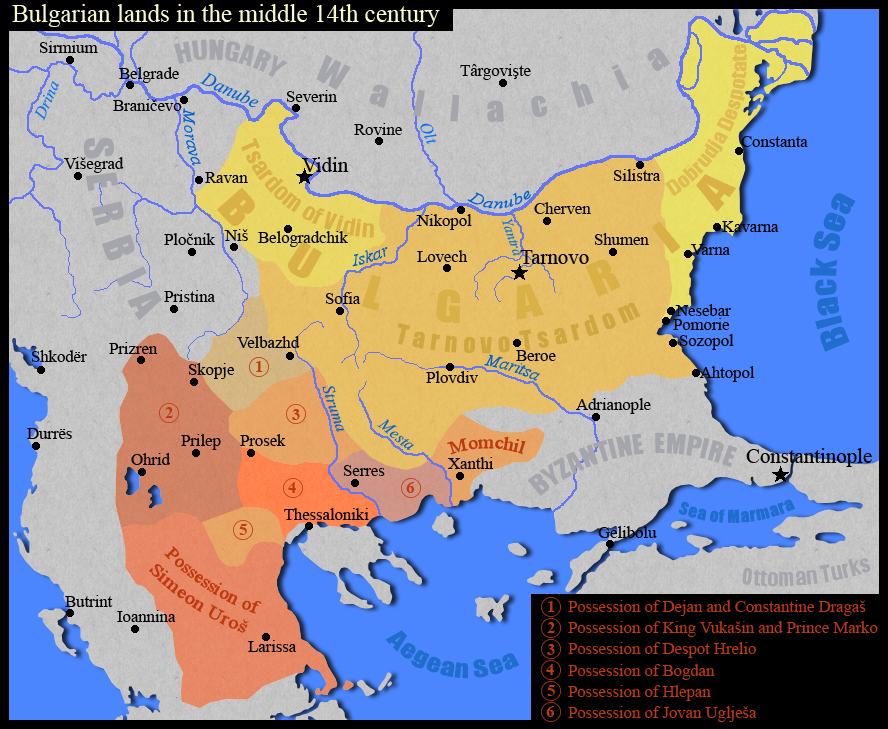
English: Тhe Bulgarian lands in the middle of the 14th century.
Български: Българските земи в средата на 14 век.
Based on map "Феодална разпокъсаност на България и падането и под турска власт (1280-1396)" in the atlas "Атлас История на България за средните училища", "Картография", София, 1990 г., стр. 8 |
| Date | |
| Source | Own work |
| Author | Kandi |
Licensing
edit
| I, the copyright holder of this work, release this work into the public domain. This applies worldwide. In some countries this may not be legally possible; if so: I grant anyone the right to use this work for any purpose, without any conditions, unless such conditions are required by law. |

|
File:Bulgarian lands 1350 vek.svg is a vector version of this file. It should be used in place of this PNG file when not inferior.
File:BG 14 vek.png → File:Bulgarian lands 1350 vek.svg
For more information, see Help:SVG. |
 |
File history
Click on a date/time to view the file as it appeared at that time.
| Date/Time | Thumbnail | Dimensions | User | Comment | |
|---|---|---|---|---|---|
| current | 17:11, 2 September 2011 | | 888 × 729 (491 KB) | Kandi (talk | contribs) | true map |
| 16:24, 2 September 2011 |  | 730 × 599 (571 KB) | Spiridon Ion Cepleanu (talk | contribs) | Names, scales and states since Codex Parisinus latinus and genovese maritime maps and descriptions in : Ph. Lauer, Catalogue des manuscrits latins, pp.95-6, d'après la Bibliothèque Nationale Lat. 1623, IX-X, Paris, 1940. And Wallachia are also a heir st | |
| 08:49, 24 January 2009 |  | 888 × 729 (442 KB) | Kandi (talk | contribs) | {{Information |Description=Тhe Bulgarian lands in the middle of the 14th century |Source=self-made |Date=24.01.2009 |Author=Kandi |Permission= |other_versions= }} Category:Maps of the history of Bulgaria Category:Maps showing 14th-century history |
You cannot overwrite this file.
File usage on Commons
The following 3 pages use this file:
File usage on other wikis
The following other wikis use this file:
- Usage on als.wikipedia.org
- Usage on bg.wikipedia.org
- Usage on en.wikipedia.org
- Usage on nl.wikipedia.org
- Usage on pl.wikipedia.org
- Usage on ru.wikipedia.org
- Usage on sr.wikipedia.org
- Usage on uk.wikipedia.org
- Usage on zh.wikipedia.org