File:Map-of-Ottoman-Empire-in-1900-German.svg

Size of this PNG preview of this SVG file: 800 × 502 pixels. Other resolutions: 320 × 201 pixels | 640 × 401 pixels | 1,024 × 642 pixels | 1,280 × 803 pixels | 2,560 × 1,605 pixels | 2,647 × 1,660 pixels.
Original file (SVG file, nominally 2,647 × 1,660 pixels, file size: 82 KB)
Captions
Captions
Add a one-line explanation of what this file represents
| Description |
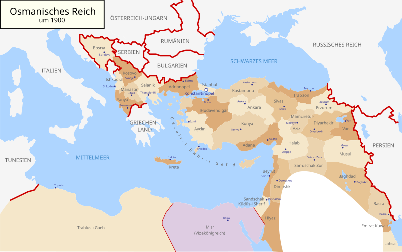
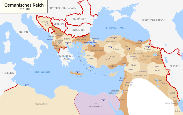
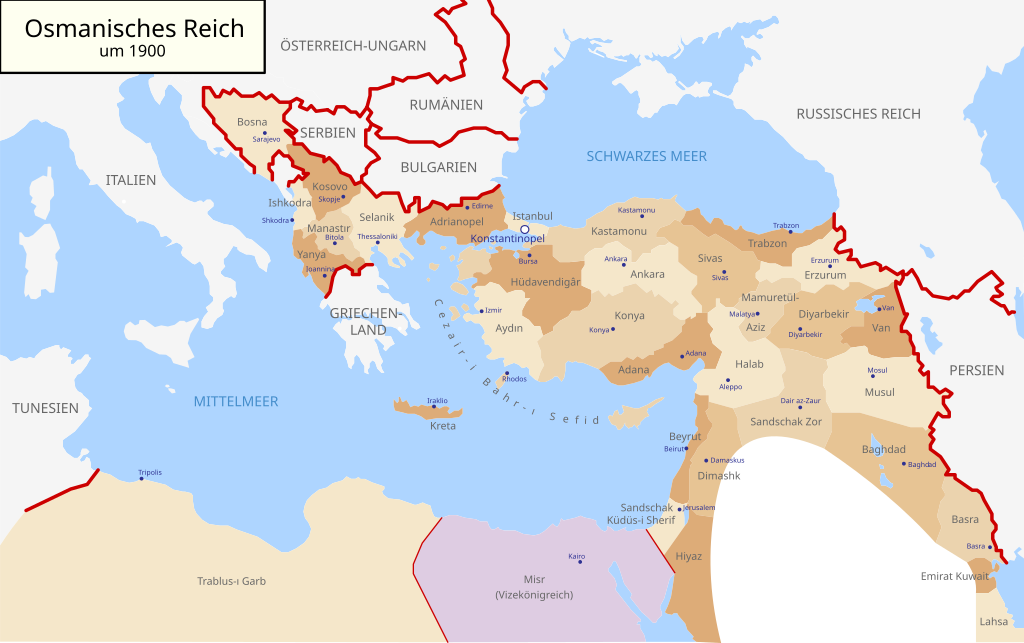
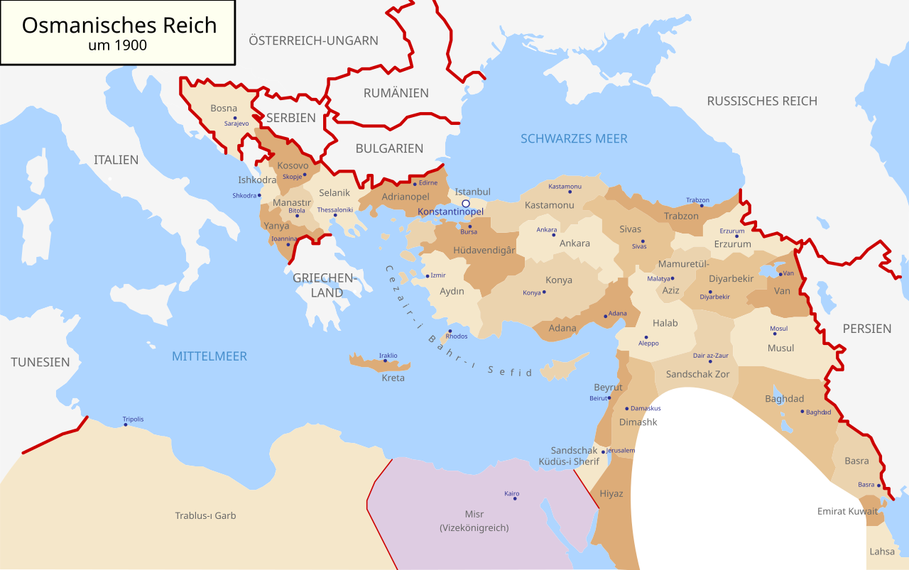
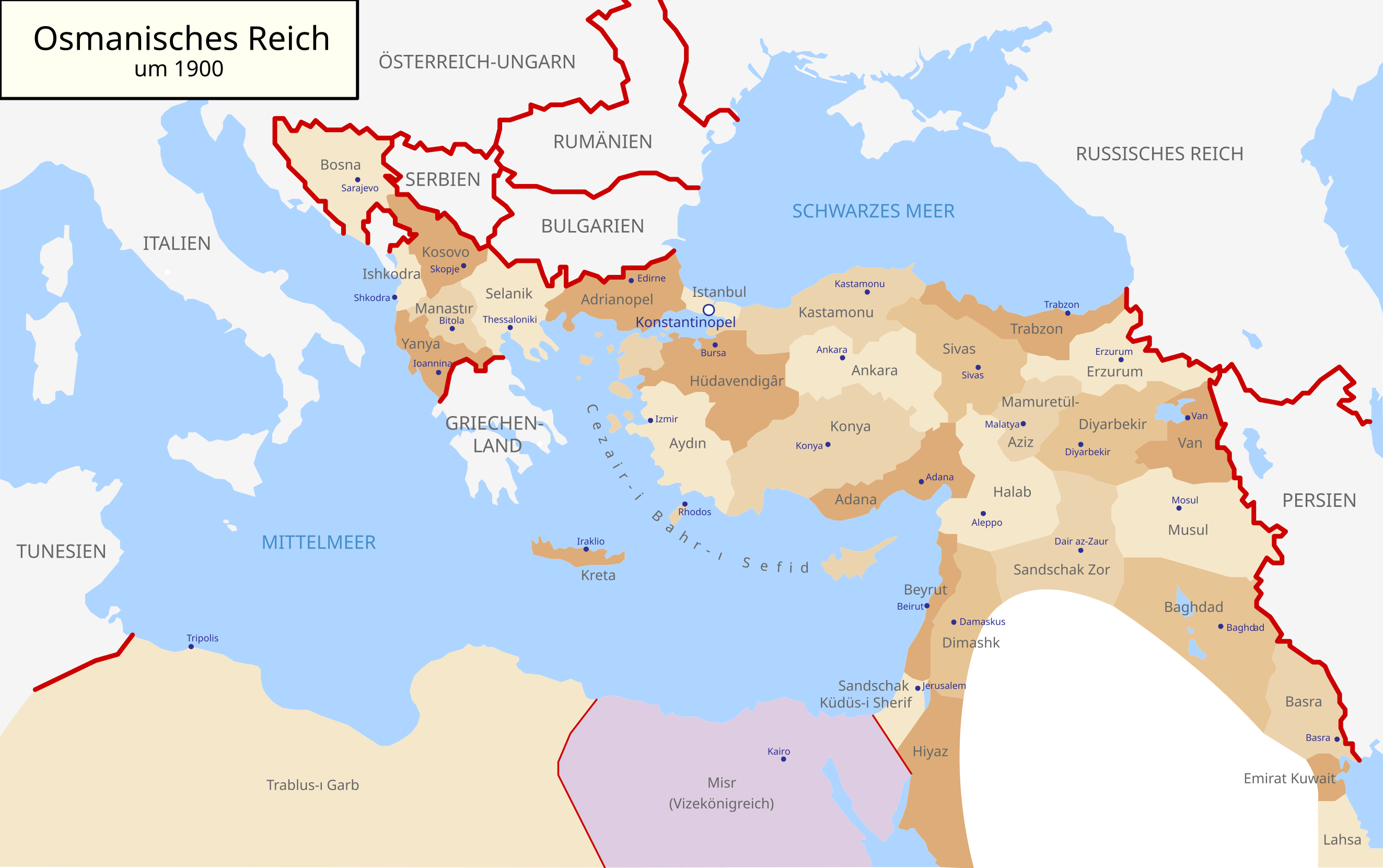
Deutsch: Karte des Osmanischen Reiches um 1900 in Deutsch
English: Map of Ottoman Empire (1900) in German |
| Date | (UTC) |
| Source | |
| Author |
|
| Other versions |
Map-of-Ottoman-Empire-in-1900-German.svg[]
Derivative works of this file: |


.svg)
.jpg)
I, the copyright holder of this work, hereby publish it under the following license:
| I, the copyright holder of this work, release this work into the public domain. This applies worldwide. In some countries this may not be legally possible; if so: I grant anyone the right to use this work for any purpose, without any conditions, unless such conditions are required by law. |
Original upload log
edit
This image is a derivative work of the following images:
- File:Map-of-Ottoman-Empire-in-1900-Latvian.svg licensed with PD-self
- 2008-01-30T21:53:09Z Juristiltins 885x557 (105823 Bytes) {{Information |Description=Map of Ottoman Empire (1900) in Latvian |Source=own work |Date=30 January 2008 |Author=Juris Tiltins |Permission=Free use and distribution permitted. |other_versions= }} [[Category:Maps of the Ottom
Uploaded with derivativeFX
File history
Click on a date/time to view the file as it appeared at that time.
| Date/Time | Thumbnail | Dimensions | User | Comment | |
|---|---|---|---|---|---|
| current | 09:25, 18 May 2018 | | 2,647 × 1,660 (82 KB) | NordNordWest (talk | contribs) | corr |
| 16:03, 15 September 2010 |  | 2,647 × 1,660 (79 KB) | NordNordWest (talk | contribs) | c | |
| 16:01, 15 September 2010 |  | 2,646 × 1,660 (79 KB) | NordNordWest (talk | contribs) | c | |
| 16:00, 15 September 2010 |  | 2,646 × 1,660 (79 KB) | NordNordWest (talk | contribs) | c | |
| 18:30, 28 August 2010 |  | 2,645 × 1,661 (112 KB) | NordNordWest (talk | contribs) | bigger | |
| 18:18, 28 August 2010 |  | 885 × 557 (96 KB) | NordNordWest (talk | contribs) | {{Information |Description={{de|Karte des Osmanischen Reiches um 1900 in Deutsch}} {{en|Map of Ottoman Empire (1900) in German}} |Source=*File:Map-of-Ottoman-Empire-in-1900-Latvian.svg |Date=2010-08-28 18:18 (UTC) |Author=*[[:File:Map-of-Ottoman-Emp |
You cannot overwrite this file.
File usage on Commons
The following 8 pages use this file:
- User:J budissin/Uploads/BiH/2018 May 11-20
- File:1908 Meclis-i Mebusân members by vilayet (or sanjak) and ethnicity.svg
- File:Map-of-Ottoman-Empire-in-1900-German.svg
- File:Map-of-Ottoman-Empire-in-1900-Latvian.svg
- File:Map-of-Ottoman-Empire-in-1900-Spanish.svg
- File:Map-of-Ottoman-Empire-in-1900.png
- File:Map of Ottoman Empire in 1900-hu.svg
- Template:Other versions/Map of Ottoman Empire (1900)
_and_ethnicity.svg)
File usage on other wikis
The following other wikis use this file:
- Usage on af.wikipedia.org
- Usage on als.wikipedia.org
- Usage on cy.wikipedia.org
- Usage on de.wikipedia.org
- Usage on en.wikipedia.org
- Usage on he.wikipedia.org
- Usage on it.wikipedia.org
- Usage on lv.wikipedia.org
- Usage on no.wikipedia.org
- Usage on pl.wikipedia.org
- Usage on pnb.wikipedia.org
- Usage on ru.wikipedia.org
- Usage on sk.wikipedia.org
- Usage on sr.wikipedia.org
- Usage on sv.wikipedia.org
- Usage on tr.wikipedia.org
- Usage on ur.wikipedia.org