File:Karte Sprachen Graubünden.png
Size of this preview: 648 × 600 pixels. Other resolutions: 259 × 240 pixels | 519 × 480 pixels | 900 × 833 pixels.
Original file (900 × 833 pixels, file size: 190 KB, MIME type: image/png)
Captions
Captions
Add a one-line explanation of what this file represents

|
This linguistic map image could be re-created using vector graphics as an SVG file. This has several advantages; see Commons:Media for cleanup for more information. If an SVG form of this image is available, please upload it and afterwards replace this template with
{{vector version available|new image name}}.
It is recommended to name the SVG file “Karte Sprachen Graubünden.svg”—then the template Vector version available (or Vva) does not need the new image name parameter. |
Summary
edit
| Description |
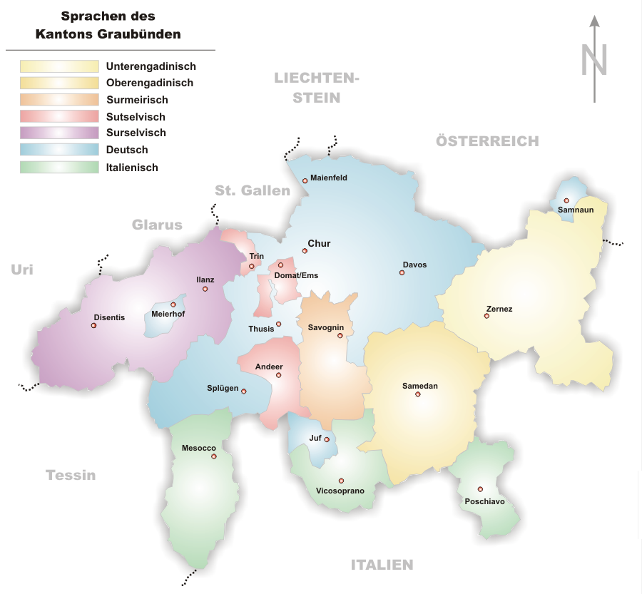
source: http://de.wikipedia.org/wiki/Bild:Karte_Sprachen_Graubünden.png Sprachregionen im Kanton Graubünden, selbstgezeichnet von Tschubby |
| Date | 29 November 2005 (original upload date) |
| Source | No machine-readable source provided. Own work assumed (based on copyright claims). |
| Author | No machine-readable author provided. Wiki-vr assumed (based on copyright claims). |
Licensing
edit
| I, the copyright holder of this work, release this work into the public domain. This applies worldwide. In some countries this may not be legally possible; if so: I grant anyone the right to use this work for any purpose, without any conditions, unless such conditions are required by law. |
File history
Click on a date/time to view the file as it appeared at that time.
| Date/Time | Thumbnail | Dimensions | User | Comment | |
|---|---|---|---|---|---|
| current | 09:07, 4 December 2005 | | 900 × 833 (190 KB) | Wiki-vr (talk | contribs) | small corrections |
| 15:40, 29 November 2005 |  | 902 × 833 (190 KB) | Wiki-vr (talk | contribs) | source: http://de.wikipedia.org/wiki/Bild:Karte_Sprachen_Graubünden.png Sprachregionen im Kanton Graubünden, selbstgezeichnet von Tschubby Category:Maps of Canton of Grisons |
You cannot overwrite this file.
File usage on Commons
There are no pages that use this file.
File usage on other wikis
The following other wikis use this file:
- Usage on als.wikipedia.org
- Usage on cs.wikipedia.org
- Usage on de.wikipedia.org
- Usage on eo.wikipedia.org
- Usage on eu.wikipedia.org
- Usage on fr.wikipedia.org
- Usage on hu.wikipedia.org
- Usage on la.wikipedia.org
- Usage on lmo.wikipedia.org
- Usage on ln.wikipedia.org
- Usage on sv.wikipedia.org