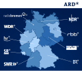
File:ARD Karte.svg

Size of this PNG preview of this SVG file: 730 × 599 pixels. Other resolutions: 292 × 240 pixels | 585 × 480 pixels | 935 × 768 pixels | 1,247 × 1,024 pixels | 2,494 × 2,048 pixels | 950 × 780 pixels.
Original file (SVG file, nominally 950 × 780 pixels, file size: 59 KB)
File information
Structured data
Captions
Captions
Ard_Chart
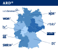
Karte der Landesrundfunkanstalten der ARD mit ihren Sendeanstalten
Summary
edit| DescriptionARD Karte.svg |
English: Map of the ARD member broadcasters.
Français : Carte des radiodiffuseurs membre de ARD |
| Date | |
| Source |
|
| Author | Daisy0705, Dagobert50gold, StG1990, Martin Kraft, Radiohörer |
| Other versions |
|
| SVG development InfoField |
Licensing
edit| Public domainPublic domainfalsefalse |
| This work is ineligible for copyright and therefore in the public domain because it consists entirely of information that is common property and contains no original authorship. |

|
This work includes material that may be protected as a trademark in some jurisdictions. If you want to use it, you have to ensure that you have the legal right to do so and that you do not infringe any trademark rights. See our general disclaimer. This tag does not indicate the copyright status of the attached work. A normal copyright tag is still required. See Commons:Licensing. |
This file is licensed under the Creative Commons Attribution-Share Alike 2.0 Germany license.
- You are free:
- to share – to copy, distribute and transmit the work
- to remix – to adapt the work
- Under the following conditions:
- attribution – You must give appropriate credit, provide a link to the license, and indicate if changes were made. You may do so in any reasonable manner, but not in any way that suggests the licensor endorses you or your use.
- share alike – If you remix, transform, or build upon the material, you must distribute your contributions under the same or compatible license as the original.

Original upload log
editThe original description page was here. All following user names refer to de.wikipedia.
- 2012-01-05 16:25 StG1990 950×801 (134245 bytes) Logofarben rausgeworfen, ist schließlich keine Werbebroschüre
- 2012-01-05 15:47 Dagobert50gold 934×801 (144392 bytes)
- 2012-01-05 15:26 Dagobert50gold 934×801 (144368 bytes) Bayern nun hell wie Logo, + Korrektur der anderen Länder
- 2008-01-08 21:07 GringoStar 950×801 (205451 bytes)
- 2007-11-16 19:49 GringoStar 950×801 (205524 bytes) {{Information |Beschreibung = |Quelle = |Urheber = |Datum = |Genehmigung = |Andere Versionen = |Anmerkungen = }}
- 2007-10-09 20:35 Okfm 950×801 (207939 bytes)
- 2007-02-11 13:47 Gissi 950×801 (214815 bytes) {{Information |Beschreibung=Karte mit den regionalen Rundfunkanstalten der ARD. Die ursprüngliche, nicht-vektorisierte Variante stammte aus der deutschsprachigen Wikipedia. Die neue Karte basiert auf [[:commons:Image:Deutschland Lage von Baden-Württembe
File history
Click on a date/time to view the file as it appeared at that time.
| Date/Time | Thumbnail | Dimensions | User | Comment | |
|---|---|---|---|---|---|
| current | 21:30, 31 October 2023 |  | 950 × 780 (59 KB) | DimiDimi (talk | contribs) | HR und SR-Logo aktualisiert |
| 22:09, 28 May 2019 |  | 950 × 780 (55 KB) | Perhelion (talk | contribs) | fix dimension for imagemap // Editing SVG source code using User:Rillke/SVGedit.js; upload handled by User:Rillke/MwJSBot.js | |
| 00:10, 23 September 2018 |  | 512 × 420 (55 KB) | Perhelion (talk | contribs) | fix lines (again real vector) | |
| 21:33, 21 May 2018 |  | 950 × 780 (191 KB) | Paul Ewe (talk | contribs) | Reverted to version as of 11:01, 30 August 2017 (UTC) MDR-Linie verschwunden | |
| 20:10, 21 January 2018 |  | 512 × 420 (82 KB) | Teo.raff (talk | contribs) | Vector image | |
| 11:01, 30 August 2017 |  | 950 × 780 (191 KB) | Adrio (talk | contribs) | Neues rbb-Logo eingefügt | |
| 19:30, 15 January 2017 |  | 950 × 780 (188 KB) | Dasas (talk | contribs) | Neues MDR-Logo eingefügt | |
| 19:28, 15 January 2017 |  | 950 × 780 (188 KB) | Dasas (talk | contribs) | Neues MDR-Logo eingefügt | |
| 19:33, 5 May 2012 |  | 950 × 780 (132 KB) | Be11 (talk | contribs) | Logos korrekt ausgerichtet | |
| 18:25, 5 May 2012 |  | 950 × 780 (128 KB) | Martin Kraft (talk | contribs) | Reverted to version as of 22:09, 2 May 2012 Bitte Diskussionsstand und Abstimmungsergebnis beachten! |
You cannot overwrite this file.
File usage on Commons
The following 37 pages use this file:
- Atlas of Germany
- Rundfunk Berlin-Brandenburg
- User:Chumwa/OgreBot/Travel and communication maps/2017 August 21-31
- User:Chumwa/OgreBot/Travel and communication maps/2017 January 11-20
- User:Chumwa/OgreBot/Travel and communication maps/2018 January 21-31
- User:Chumwa/OgreBot/Travel and communication maps/2018 May 21-31
- User:Chumwa/OgreBot/Travel and communication maps/2018 September 21-30
- User:Chumwa/OgreBot/Travel and communication maps/2019 May 21-31
- User:Chumwa/OgreBot/Travel and communication maps/2023 October 21-31
- User:Magog the Ogre/PD ineligible/2017 August 28-31
- User:Magog the Ogre/PD ineligible/2017 January 12-15
- User:Magog the Ogre/PD ineligible/2018 January 20-23
- User:Magog the Ogre/PD ineligible/2018 May 20-23
- User:Magog the Ogre/PD ineligible/2018 September 23-26
- User:Magog the Ogre/PD ineligible/2019 May 28-31
- File:ARD-Hitnacht 2020.svg
- File:ARD-Infonacht 2020.svg
- File:ARD-Nachtkonzert 2020.svg
- File:ARD-die-junge-nacht-der-ARD 2018.svg
- File:Ard-popnacht 2018.svg
- File:Carte stations ARD.png
- File:Landesrundfunkanstalten.svg
- File:Landesrundfunkanstalten dunkel.svg
- File:Landesrundfunkanstalten hell.svg
- File talk:ARD Karte.svg
- Category:Bayerischer Rundfunk
- Category:HR people
- Category:Hessischer Rundfunk
- Category:NDR people
- Category:Norddeutscher Rundfunk
- Category:People of Bayerischer Rundfunk
- Category:RBB people
- Category:Rundfunk Berlin-Brandenburg
- Category:SWR people
- Category:Südwestrundfunk
- Category:WDR people
- Category:Westdeutscher Rundfunk
File usage on other wikis
The following other wikis use this file:
- Usage on als.wikipedia.org
- Usage on ar.wikipedia.org
- Usage on ast.wikipedia.org
- Usage on bar.wikipedia.org
- Usage on cs.wikipedia.org
- Usage on da.wikipedia.org
- Usage on de.wikipedia.org
- ARD
- Mitteldeutschland
- Radio Bremen
- Sender Freies Berlin
- Drittes Fernsehprogramm
- Hessischer Rundfunk
- Südwestrundfunk
- Westdeutscher Rundfunk Köln
- Rundfunk Berlin-Brandenburg
- Öffentlich-rechtlicher Rundfunk
- Norddeutscher Rundfunk
- Ostdeutscher Rundfunk Brandenburg
- Südwestfunk
- Neugliederung des Bundesgebietes
- Süddeutscher Rundfunk
- Landesrundfunkanstalt
- Nordwestdeutscher Rundfunk
- Traffic Message Channel
- Diskussion:Süddeutscher Rundfunk
- Diskussion:Das Erste
- Benutzer:WikiNight
- Mitteldeutscher Rundfunk
- Vorlage:Landesrundfunkanstalt-Karte
- Fernsehen in Deutschland
- Benutzer:Gissi/Bilder
- Vorlage:Landesrundfunkanstalt-Karte/Doku
- Saarländischer Rundfunk
- Depublizieren
- Benutzer:Magnus Manske/test1
- Wikipedia:Grafikwerkstatt/Archiv/2012/März
- Diskussion:Landesrundfunkanstalt
- Benutzer Diskussion:Martin Kraft/Archiv
- Bayerischer Rundfunk
- Diskussion:ARD/Archiv
- Kultur Deutschlands
- Wikipedia:WikiProjekt Vorlagen/Werkstatt/Archiv 2019/2
- Vorlage:Infobox Landesrundfunkanstalt
- Vorlage:Landesrundfunkanstalten-Karte
- Usage on de.wikinews.org
- Usage on el.wikipedia.org
- Usage on en.wikipedia.org
View more global usage of this file.
Metadata
This file contains additional information such as Exif metadata which may have been added by the digital camera, scanner, or software program used to create or digitize it. If the file has been modified from its original state, some details such as the timestamp may not fully reflect those of the original file. The timestamp is only as accurate as the clock in the camera, and it may be completely wrong.
| Width | 950 |
|---|---|
| Height | 780 |


