File:LuxembourgPartitionsMap deutsch.jpg
No higher resolution available.
LuxembourgPartitionsMap_deutsch.jpg (433 × 588 pixels, file size: 84 KB, MIME type: image/jpeg)
Captions
Captions
Add a one-line explanation of what this file represents

|
This historical map image could be re-created using vector graphics as an SVG file. This has several advantages; see Commons:Media for cleanup for more information. If an SVG form of this image is available, please upload it and afterwards replace this template with
{{vector version available|new image name}}.
It is recommended to name the SVG file “LuxembourgPartitionsMap deutsch.svg”—then the template Vector version available (or Vva) does not need the new image name parameter. |

Summary
edit| Description |
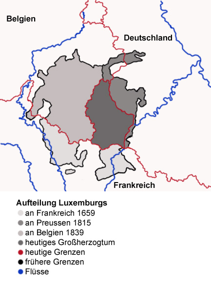
English: Map showing the partition of Luxembourg through the centuries, with German explanations.
Français : Carte montrant la partition du Luxembourg à travers les siècles, avec explications en allemand. |
| Date | |
| Source |
|
| Author | Spanish_Inquisition |
| Other versions |
|


Licensing
edit
| I, the copyright holder of this work, release this work into the public domain. This applies worldwide. In some countries this may not be legally possible; if so: I grant anyone the right to use this work for any purpose, without any conditions, unless such conditions are required by law. |
File history
Click on a date/time to view the file as it appeared at that time.
| Date/Time | Thumbnail | Dimensions | User | Comment | |
|---|---|---|---|---|---|
| current | 14:59, 3 September 2006 | | 433 × 588 (84 KB) | Spanish Inquisition (talk | contribs) | Map showing the partition of Luxembourg thorugh the centuries with german explanantions. Modification of the image LuxembourgPartitionsMap.png by user:QuartierLatin1968 14:10, 22 Apr 2005 (UTC). Author: user:Spanish_Inquisition Date: 3rd September 2006 |
You cannot overwrite this file.
File usage on Commons
The following 5 pages use this file:
File usage on other wikis
The following other wikis use this file:
- Usage on als.wikipedia.org
- Usage on de.wikipedia.org
- Usage on en.wikipedia.org
- Usage on eo.wikipedia.org