File:Alsaceregionsnaturelles.jpg

Size of this preview: 412 × 599 pixels. Other resolutions: 165 × 240 pixels | 443 × 644 pixels.
Original file (443 × 644 pixels, file size: 177 KB, MIME type: image/jpeg)
Captions
Captions
Add a one-line explanation of what this file represents
Summary
edit
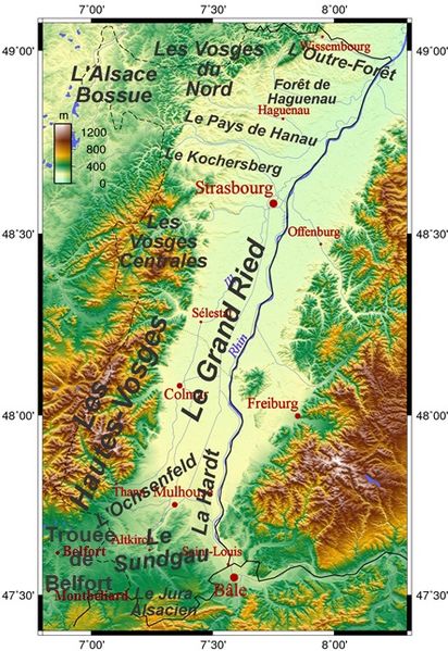
| Description | carte complétée avec régions naturelles |
| Date | 5 février |
| Source | File:Alsace topo.png |
| Author |
|
| This is a retouched picture, which means that it has been digitally altered from its original version. Modifications: added sub-regions of Alsace. The original can be viewed here: Alsace topo.png:
|
Licensing
edit
The map has been created with the Generic Mapping Tools: https://www.generic-mapping-tools.org/ using one or more of these public-domain datasets for the relief:
|

|
Permission is granted to copy, distribute and/or modify this document under the terms of the GNU Free Documentation License, Version 1.2 or any later version published by the Free Software Foundation; with no Invariant Sections, no Front-Cover Texts, and no Back-Cover Texts. A copy of the license is included in the section entitled GNU Free Documentation License. |
| This file is licensed under the Creative Commons Attribution-Share Alike 3.0 Unported license. | ||
| ||
| This licensing tag was added to this file as part of the GFDL licensing update. |
File history
Click on a date/time to view the file as it appeared at that time.
| Date/Time | Thumbnail | Dimensions | User | Comment | |
|---|---|---|---|---|---|
| current | 19:27, 30 December 2015 | | 443 × 644 (177 KB) | Monsieur Fou (talk | contribs) | mise à jour |
| 19:44, 5 February 2008 |  | 443 × 644 (461 KB) | Monsieur Fou (talk | contribs) | {{Information |Description= carte complétée avec régions naturelles |Source=wikipedia |Date=5 février |Author= |Permission=toutes |other_versions= }} |
You cannot overwrite this file.
File usage on Commons
The following 2 pages use this file:
File usage on other wikis
The following other wikis use this file:
- Usage on als.wikipedia.org
- Sundgau
- Krummes Elsass
- Wikipedia:Houptsyte/Bildervorlagen
- Vorlage:Houptsyte/Bilder/23.05
- Vorlage:Houptsyte/Bilder/24.05
- Vorlage:Houptsyte/Bilder/25.05
- Vorlage:Houptsyte/Bilder/26.05
- Vorlage:Houptsyte/Bilder/27.05
- Vorlage:Houptsyte/Bilder/28.05
- Vorlage:Houptsyte/Bilder/29.05
- Vorlage:Houptsyte/Bilder/30.05
- Vorlage:Houptsyte/Bilder/31.05
- Usage on bg.wikipedia.org
- Usage on de.wikipedia.org
- Usage on el.wikipedia.org
- Usage on en.wikipedia.org
- Usage on es.wikipedia.org
- Usage on fr.wikipedia.org
- Haut-Rhin
- Trouée de Belfort
- Sundgau
- Kochersberg
- Parc naturel régional des Vosges du Nord
- Alsace bossue
- Portail:Alsace
- Jura alsacien
- Forêt de la Hardt
- Portail:Alsace/Welkuma
- Portail:Alsace/Géographie
- Alsace
- Pays de la région mulhousienne
- Ochsenfeld
- Grand Ried
- Outre-Forêt
- Histoire de la culture des céréales
View more global usage of this file.