File:MapTurkishProvincesNumbers.svg

Original file (SVG file, nominally 1,052 × 744 pixels, file size: 258 KB)
Captions
Captions
Summary
edit
| Description |
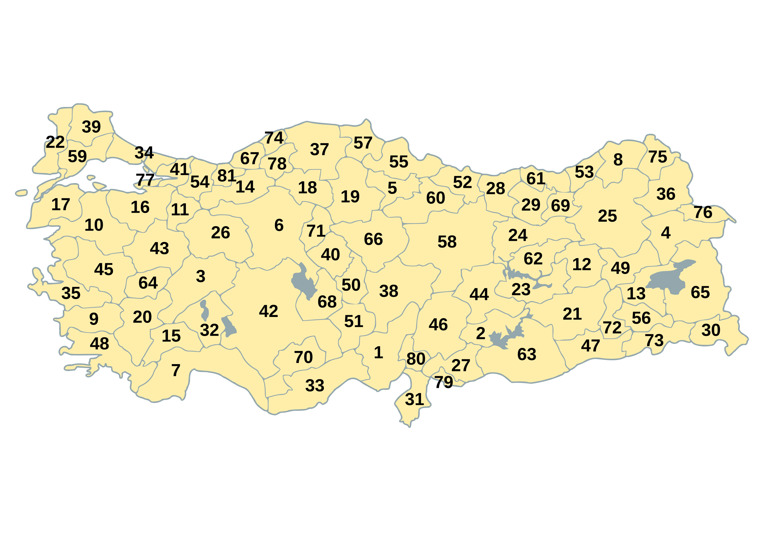
Map of Republic of Turkey's provinces, including ISO 3166-2 code numbers. These numbers are also used on Turkish car number plates. The original map is available as Image:BlankMapTurkeyProvinces.png. The author gave the following information: Description=Blank map of Republic of Turkey's provinces. The regions are carefully separated on per pixel basis and ready for filling in with a paint tool. Source=Self drawn from scratch, based on data from official Turkish motorway network map Date=December 21, 2006 Author=Atilim Gunes Baydin Permission=I grant permission for anyone to use this under the terms of GFDL license, see below |
| Date | 21 December 2006 (original upload date) |
| Source | Originally from commons.wikipedia; description page is/was here. |
| Author |
Modifications made by user User:Hk_kng at commons.wikipedia Original uploader was AtilimGunesBaydin at commons.wikipedia |
Original upload log
edit
(All user names refer to commons.wikipedia)
- 2007-02-18 22:14 AtilimGunesBaydin 1024×500×8 (23317 bytes) Removed Samothraki, which was accidentally included. I'm sorry for the mistake.
- 2006-12-22 16:46 AtilimGunesBaydin 1024×500×8 (23347 bytes) Slight resize.
- 2006-12-21 21:51 AtilimGunesBaydin 1024×499×8 (23338 bytes) {{Information |Description=Blank map of [[:en:Turkey|Republic of Turkey]]'s provinces |Source=Drawn from scratch on based on data from [http://www.kgm.gov.tr/images/trkh-yeni1.jpg official Turkish motorway network map] |Date=December 21, 2006 |Author=[[:e
Licensing
edit

|
Permission is granted to copy, distribute and/or modify this document under the terms of the GNU Free Documentation License, Version 1.2 or any later version published by the Free Software Foundation; with no Invariant Sections, no Front-Cover Texts, and no Back-Cover Texts. A copy of the license is included in the section entitled GNU Free Documentation License. |
| This file is licensed under the Creative Commons Attribution-Share Alike 3.0 Unported license. | ||
| ||
| This licensing tag was added to this file as part of the GFDL licensing update. |
File history
Click on a date/time to view the file as it appeared at that time.
| Date/Time | Thumbnail | Dimensions | User | Comment | |
|---|---|---|---|---|---|
| current | 15:27, 3 June 2015 | | 1,052 × 744 (258 KB) | Sangjinhwa (talk | contribs) | Reverted to version as of 02:48, 9 April 2007 |
| 20:57, 30 November 2014 |  | 5,000 × 2,166 (10.76 MB) | Gloyacks (talk | contribs) | 영문지명 추가 | |
| 10:33, 13 October 2014 |  | 5,000 × 2,166 (3.92 MB) | Gloyacks (talk | contribs) | 원작성본 올림 | |
| 19:09, 12 October 2014 |  | 2,250 × 975 (1.26 MB) | Gloyacks (talk | contribs) | 재작성 | |
| 02:48, 9 April 2007 |  | 1,052 × 744 (258 KB) | Hk kng (talk | contribs) | {{Information |Description=Map of Republic of Turkey's provinces, including ISO 3166-2 code numbers. These numbers are also used on Turkish car number plates. The original map is available as Image:BlankMapTurkeyProvinces.png. The aut |
You cannot overwrite this file.
File usage on Commons
There are no pages that use this file.
File usage on other wikis
The following other wikis use this file:
- Usage on de.wikipedia.org
- Usage on el.wikipedia.org
- Usage on en.wikipedia.org
- Usage on eo.wikipedia.org
- Usage on fa.wikipedia.org
- Usage on frr.wikipedia.org
- Usage on it.wikipedia.org
- Usage on ja.wikipedia.org
- Usage on tr.wikipedia.org
- Usage on uk.wikipedia.org
- Usage on ur.wikipedia.org
- Usage on zh.wikipedia.org