File:Ukrainian State 1918.11-12.png
Size of this preview: 800 × 489 pixels. Other resolutions: 320 × 196 pixels | 640 × 391 pixels | 1,200 × 734 pixels.
Original file (1,200 × 734 pixels, file size: 514 KB, MIME type: image/png)
Captions
Captions
Add a one-line explanation of what this file represents

|
This historical map image could be re-created using vector graphics as an SVG file. This has several advantages; see Commons:Media for cleanup for more information. If an SVG form of this image is available, please upload it and afterwards replace this template with
{{vector version available|new image name}}.
It is recommended to name the SVG file “Ukrainian State 1918.11-12.svg”—then the template Vector version available (or Vva) does not need the new image name parameter. |
| Description |
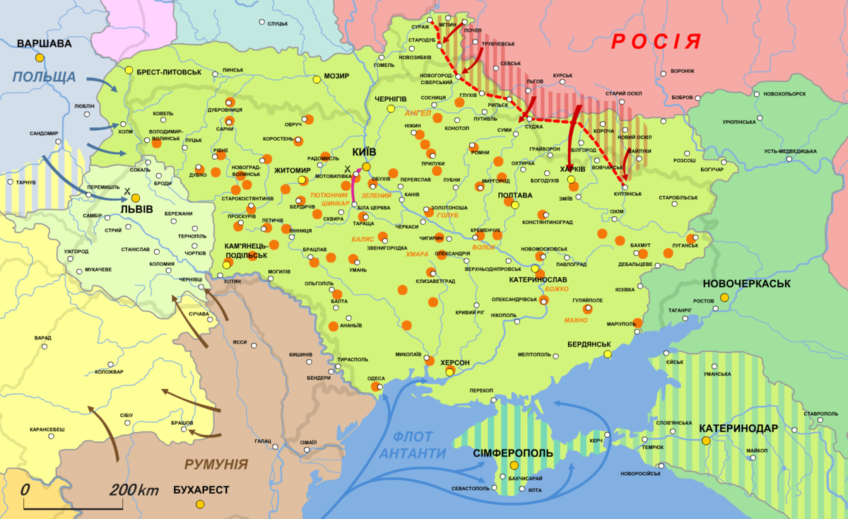
Українська: Карта Української держави (1918.XI-XII)
Українська держава
Західноукраїнська народна республіка (від 19.X.1918)
Кримський крайовий уряд (мусив увійти до складу Української держави на правах автономії)
Кубанська народна республіка (мусила увійти до складу Української держави на правах автономії)
Радянська Росія
Демаркаційна лінія між Україною та Росією
Нейтральна зона між Україною та Росією
Антиурядові повстання.
Похід Директорії на Київ
Наступ поляків на Холмщину й ЗУНР
Наступ більшовиків на Східну Україну
Наступ румунів Буковини
English: Map of the Ukrainian State (1918.XI-XIS)
日本語: ウクライナ国の地図 (1918年11月‐12月) |
| Date | |
| Source | Own work, based on Українська держава, утворення Директорії та відновлення УНР (травень - листопад 1918 р) // Атлас історії України. 10 клас |
| Author | Alex Tora |
This file is licensed under the Creative Commons Attribution-Share Alike 2.1 Japan license.
- You are free:
- to share – to copy, distribute and transmit the work
- to remix – to adapt the work
- Under the following conditions:
- attribution – You must give appropriate credit, provide a link to the license, and indicate if changes were made. You may do so in any reasonable manner, but not in any way that suggests the licensor endorses you or your use.
- share alike – If you remix, transform, or build upon the material, you must distribute your contributions under the same or compatible license as the original.

File history
Click on a date/time to view the file as it appeared at that time.
| Date/Time | Thumbnail | Dimensions | User | Comment | |
|---|---|---|---|---|---|
| current | 18:09, 21 January 2022 | | 1,200 × 734 (514 KB) | Super Dromaeosaurus (talk | contribs) | Romania-Ukraine border at Dniester |
| 08:31, 8 February 2011 |  | 1,696 × 1,038 (472 KB) | Alex Tora (talk | contribs) | {{Information |Description={{uk|Карта Української держави (1918.XI-XII)}} {{legend|#D3F47B|Українська держава}} {{legend|#E0FEAD|[[:uk:Західноукраїнська � |
You cannot overwrite this file.
File usage on Commons
There are no pages that use this file.
File usage on other wikis
The following other wikis use this file:
- Usage on ar.wikipedia.org
- Usage on be-tarask.wikipedia.org
- Usage on be.wikipedia.org
- Usage on bn.wikipedia.org
- Usage on cs.wikipedia.org
- Usage on en.wikipedia.org
- Usage on es.wikipedia.org
- Usage on he.wikipedia.org
- Usage on it.wikipedia.org
- Usage on ja.wikipedia.org
- Usage on lt.wikipedia.org
- Usage on pt.wikipedia.org
- Usage on ro.wikipedia.org
- Usage on ru.wikipedia.org
- Usage on sr.wikipedia.org
- Usage on tr.wikipedia.org
- Usage on uk.wikipedia.org
- Usage on vi.wikipedia.org