File:Pagania.png

Size of this preview: 800 × 593 pixels. Other resolutions: 320 × 237 pixels | 640 × 474 pixels | 843 × 625 pixels.
Original file (843 × 625 pixels, file size: 57 KB, MIME type: image/png)
Captions
Captions
Add a one-line explanation of what this file represents
Summary
edit
| Description |
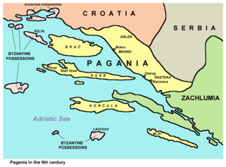
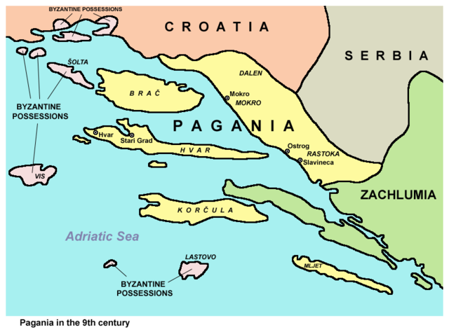
Historic map - Pagania in the 9th century.
|
| Date | 28 December 2006 (original upload date) |
| Source | Own work |
| Author | PANONIAN |
Source and license
edit

|
This map has been uploaded by Electionworld from en.wikipedia.org to enable the |
self made map by User:PANONIAN
Licensing
edit
| I, the copyright holder of this work, release this work into the public domain. This applies worldwide. In some countries this may not be legally possible; if so: I grant anyone the right to use this work for any purpose, without any conditions, unless such conditions are required by law. |
References
edit
- Istorijski atlas, Geokarta, Beograd, 1999.
- Vladimir Ćorović, Ilustrovana istorija Srba, knjiga prva, Beograd, 2005.
- Petrit Imami, Srbi i Albanci kroz vekove, Beograd, 2000.
- Školski istorijski atlas, Zavod za izdavanje udžbenika SR Srbije, Beograd, 1970.
- The Times, Atlas Svjetske Povijesti, Cankarjeva založba, Ljubljana - Zabreb, 1986.
- Sima M. Ćirković, Srbi među evropskim narodima, Beograd, 2004.
- Sve srpske mape - od šestog veka do Pariza, Specijalno izdanje BLICA, Decembar 1995
- http://www.rgz.gov.rs/kart-proizvodi/korpa_edit.asp?ArtikalID=1000315&LanguageID=2&MenuID=0020010 archive copy at the Wayback Machine
- http://www.rgz.gov.rs/kart-proizvodi/artikli/050610.jpg archive copy at the Wayback Machine
- http://www.culturalresources.com/images/maps/CharlemagneBig.jpg
- http://xxlworld.xx.ohost.de/povijest/prilozi/7-15/do1097/05.gif archive copy at the Wayback Machine
- http://www.croatia-in-english.com/images/maps/800s.jpg
File history
Click on a date/time to view the file as it appeared at that time.
| Date/Time | Thumbnail | Dimensions | User | Comment | |
|---|---|---|---|---|---|
| current | 08:53, 3 May 2015 | | 843 × 625 (57 KB) | WikiEditor2004 (talk | contribs) | Reverted to version as of 14:20, 10 February 2015 - please upload your map under different filename |
| 23:47, 2 May 2015 |  | 800 × 447 (103 KB) | Ceha (talk | contribs) | Reverted to version as of 11:52, 19 November 2010, innland borders of other states are wrong, so better to not show them | |
| 14:20, 10 February 2015 |  | 843 × 625 (57 KB) | WikiEditor2004 (talk | contribs) | improved version | |
| 11:52, 19 November 2010 |  | 800 × 447 (103 KB) | P. S. Burton (talk | contribs) | colours changed to conform with WP map conventions | |
| 15:36, 28 December 2006 |  | 800 × 447 (33 KB) | Electionworld (talk | contribs) | {{ew|en|PANONIAN}} historic map (self made) {{PD-self}} Category:Maps of the history of Croatia |
You cannot overwrite this file.
File usage on Commons
The following page uses this file:
File usage on other wikis
The following other wikis use this file:
- Usage on cs.wikipedia.org
- Usage on de.wikipedia.org
- Usage on lt.wikipedia.org
- Usage on ru.wikipedia.org
- Usage on sl.wikipedia.org
- Usage on uk.wikipedia.org