File:Idioma kurdo1.png
No higher resolution available.
Idioma_kurdo1.png (800 × 492 pixels, file size: 13 KB, MIME type: image/png)
Captions
Captions
Add a one-line explanation of what this file represents
Any autoconfirmed user can overwrite this file from the same source. Please ensure that overwrites comply with the guideline.
Summary
edit
| Description |
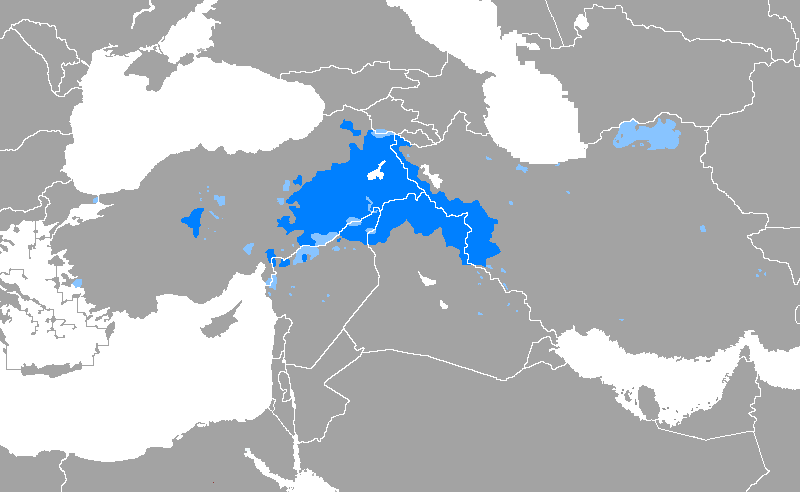
English: based on sourses Laki is a branch of southern Kurdish. i added Lakish parts. |
| Date | |
| Source | Own work based on کرد و پراکندگی او در گستره ایران زمین - ح. بهتویی - ۱۳۷۷ - تهران |
| Author | Hosseiniran |
Licensing
edit
I, the copyright holder of this work, hereby publish it under the following license:
This file is licensed under the Creative Commons Attribution-Share Alike 4.0 International license.
- You are free:
- to share – to copy, distribute and transmit the work
- to remix – to adapt the work
- Under the following conditions:
- attribution – You must give appropriate credit, provide a link to the license, and indicate if changes were made. You may do so in any reasonable manner, but not in any way that suggests the licensor endorses you or your use.
- share alike – If you remix, transform, or build upon the material, you must distribute your contributions under the same or compatible license as the original.
File history
Click on a date/time to view the file as it appeared at that time.
| Date/Time | Thumbnail | Dimensions | User | Comment | |
|---|---|---|---|---|---|
| current | 21:40, 30 November 2024 | | 800 × 492 (13 KB) | Moroike (talk | contribs) | No Indo-European language is spoken in the territory of Nagorno-Karabakh, after the dissolution of the Kurdistan Uezd and the deportation of the Kurds by Stalin in 1930 and after the flight of Nagorno-Karabakh Armenians and the collapse of the Republic of Nagorno-Karabakh in 2023. The region was twice ethnically cleansed and depopulated. Kurdish and Armenian became virtually extinct in the... |
| 16:00, 24 February 2019 |  | 800 × 492 (30 KB) | HistoryofIran (talk | contribs) | Restored map that was originally uploaded | |
| 15:59, 24 February 2019 |  | 800 × 492 (21 KB) | HistoryofIran (talk | contribs) | rv, I could say the same, the map is incorrect as hell, since when did the Kurds form a huge chunk of Mazandaran and Gilan? Clearly some pov-pushing going on here | |
| 14:53, 24 February 2019 |  | 800 × 492 (23 KB) | LenguaMapa (talk | contribs) | Reverted to version as of 01:54, 10 January 2019 (UTC) please provide a reliable source/the link of your source | |
| 11:32, 9 February 2019 |  | 800 × 492 (21 KB) | Maphobbyist (talk | contribs) | Kurdish-inhabited areas in the Middle East and the Soviet Union, from the 1986 CIA World Factbook – including Iran, Iraq, Syria and Turkey. | |
| 01:54, 10 January 2019 |  | 800 × 492 (23 KB) | JuTa (talk | contribs) | The other one is available at File:Idioma kurdo.PNG | |
| 17:13, 2 January 2019 |  | 800 × 492 (22 KB) | HistoryofIran (talk | contribs) | rv, some disruptive editor has uploaded his own POV version of the original map of https://commons.wikimedia.org/wiki/File:Idioma_kurdo.PNG | |
| 14:36, 3 December 2018 |  | 800 × 492 (23 KB) | LenguaMapa (talk | contribs) | Reverted to version as of 16:37, 9 October 2017 (UTC)The "Worldfactbook" source on the wiki article support this version more than the two others before. | |
| 20:50, 3 April 2018 |  | 800 × 492 (30 KB) | Maphobbyist (talk | contribs) | Reverted to version as of 16:31, 12 September 2016 (UTC) | |
| 16:37, 9 October 2017 |  | 800 × 492 (23 KB) | 일성강 (talk | contribs) | Reverted to version as of 14:13, 30 September 2017 (UTC),, this is the actuall version. stop turkish nationalism please. |
You cannot overwrite this file.
File usage on Commons
The following 12 pages use this file:
- User:Chumwa/OgreBot/Travel and communication maps/2016 July 1-10
- User:Chumwa/OgreBot/Travel and communication maps/2016 September 11-20
- User:Chumwa/OgreBot/Travel and communication maps/2017 October 1-10
- User:Chumwa/OgreBot/Travel and communication maps/2017 September 1-10
- User:Chumwa/OgreBot/Travel and communication maps/2017 September 11-20
- User:Chumwa/OgreBot/Travel and communication maps/2017 September 21-30
- User:Chumwa/OgreBot/Travel and communication maps/2018 April 1-10
- User:Chumwa/OgreBot/Travel and communication maps/2018 December 1-10
- User:Chumwa/OgreBot/Travel and communication maps/2019 February 1-9
- User:Chumwa/OgreBot/Travel and communication maps/2019 February 19-28
- User:Chumwa/OgreBot/Travel and communication maps/2019 January 1-10
- User:Chumwa/OgreBot/Travel and communication maps/2024 November 21-30
File usage on other wikis
The following other wikis use this file:
- Usage on am.wikipedia.org
- Usage on ceb.wikipedia.org
- Usage on gl.wikipedia.org
- Usage on hak.wikipedia.org
- Usage on incubator.wikimedia.org
- Usage on lfn.wikipedia.org
- Usage on li.wikipedia.org
- Usage on lt.wikipedia.org
- Usage on mi.wikipedia.org
- Usage on pl.wikipedia.org
- Usage on qu.wikipedia.org
- Usage on sr.wikipedia.org
- Usage on uk.wikipedia.org
- Usage on vi.wikipedia.org