File:Reindeer Island ESA388436.jpg
Original file (3,000 × 2,329 pixels, file size: 6.51 MB, MIME type: image/jpeg)
Captions
Captions
Summary
edit| Description |
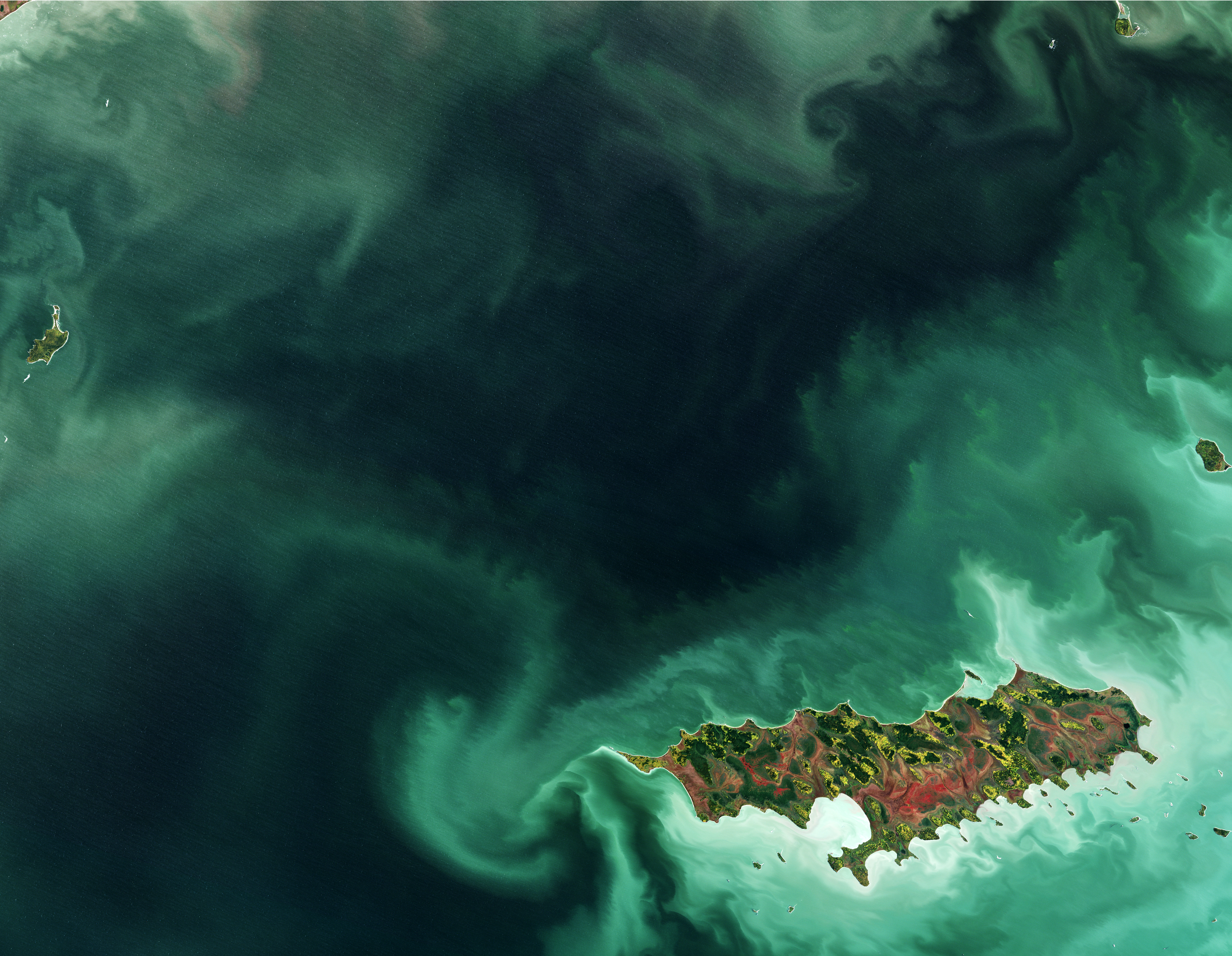
English: The Copernicus Sentinel-2 mission takes us over part of Lake Winnipeg in the Canadian province of Manitoba, with Reindeer Island visible in the lower-right part of the image.
While our friends on the other side of the pond might be able to tell us why this place is called ‘Reindeer Island’, we believe that this is a rest-stop for Santa Claus during his busy night before Christmas. Smaller islands can be seen along the edges of the image, while the swirling shades of green in the waters is an algal bloom. Although algae grows naturally in the lake, high levels of phosphorus – found in fertilisers and common household products – seeping into the water have caused a steady surge of toxic cyanobacteria, or blue–green algae, posing a threat to ecology and human health. Sentinel-2’s frequent revisits over the same area and high resolution allow changes in inland water bodies and the coastal environment to be closely monitored. With its 13 spectral channels, the mission’s novel imager can capture water quality indicators such as the surface concentration of chlorophyll, detect harmful algal blooms and measure water clarity – giving a clear indication of the health and pollution levels. By providing measurements of water quality and detecting changes, Sentinel-2 supports the sustainable management of water resources, and can also indicate areas that are safe, or unsafe, for swimming. This image, also featured on the Earth from Space video programme, was captured on 6 October 2017.Українська: Супутниковий знімок Оленячого острова на озері Вінніпег у канадській провінції Манітоба, зроблений супутником Сентінел-2 (Sentinel-2) за програмою Копернік (Copernicus) Європейської космічної агенції (ESA).
Різні відтінки зеленого кольору у водах озера позначають різний ступінь цвітіння води, тобто розмноження синьо-зелених водоростей. Цьому сприяють сільськогосподарські стоки з навколишніх полів, що містять підвищений рівень фосфатів через застосування мінеральних добрив та побутові стічні води насичені фосфоровмісними сполуками мийних засобів. Надмірне розмноження таких водоростей може становити загрозу місцевій екології та здоров'ю людей. Завдяки 13 спектральним каналам супутника Сентінель-2 можна фіксувати показники якості води, поверхневу концентрацію хлорофілу, виявляти шкідливе цвітіння водоростей, вимірювати прозорість води. Такий моніторинг дозволяє управляти водними ресурсами. Це зображення було використане у відеоролику програми "Земля з космосу" 6 жовтня 2017 року. |
| Date | |
| Source | http://www.esa.int/spaceinimages/Images/2017/12/Reindeer_Island |
| Author | European Space Agency |
| Permission (Reusing this file) |
contains modified Copernicus Sentinel data (2017), processed by ESA,CC BY-SA 3.0 IGO |
| Other versions |
|
| Title | Reindeer Island |
| System | Copernicus |
| Set | Earth observation image of the week |
| Location | Canada |
| Mission | Sentinel-2 |
| Activity | Observing the Earth |

Licensing
edit
- You are free:
- to share – to copy, distribute and transmit the work
- to remix – to adapt the work
- Under the following conditions:
- attribution – You must give appropriate credit, provide a link to the license, and indicate if changes were made. You may do so in any reasonable manner, but not in any way that suggests the licensor endorses you or your use.
- share alike – If you remix, transform, or build upon the material, you must distribute your contributions under the same or compatible license as the original.

|
This image contains data from a satellite in the Copernicus Programme, such as Sentinel-1, Sentinel-2 or Sentinel-3. Attribution is required when using this image.
Attribution: Contains modified Copernicus Sentinel data {{{year}}}
The use of Copernicus Sentinel Data is regulated under EU law (Commission Delegated Regulation (EU) No 1159/2013 and Regulation (EU) No 377/2014). Relevant excerpts:
Free access shall be given to GMES dedicated data [...] made available through GMES dissemination platforms [...].
Access to GMES dedicated data [...] shall be given for the purpose of the following use in so far as it is lawful:
GMES dedicated data [...] may be used worldwide without limitations in time.
GMES dedicated data and GMES service information are provided to users without any express or implied warranty, including as regards quality and suitability for any purpose. |
File history
Click on a date/time to view the file as it appeared at that time.
| Date/Time | Thumbnail | Dimensions | User | Comment | |
|---|---|---|---|---|---|
| current | 14:55, 30 December 2017 | | 3,000 × 2,329 (6.51 MB) | Fæ (talk | contribs) | European Space Agency, Id 388436, http://www.esa.int/spaceinimages/Images/2017/12/Reindeer_Island, User:Fæ/Project_list/ESA |
You cannot overwrite this file.
File usage on Commons
The following 3 pages use this file:
.jpg&redirect=no)
File usage on other wikis
The following other wikis use this file:
- Usage on ceb.wikipedia.org
- Usage on es.wikipedia.org
- Usage on fi.wikipedia.org
- Usage on pl.wikipedia.org
- Usage on uk.wikipedia.org
- Usage on www.wikidata.org