File:France sites unesco.png
Size of this preview: 668 × 600 pixels. Other resolutions: 267 × 240 pixels | 535 × 480 pixels | 855 × 768 pixels | 1,140 × 1,024 pixels | 2,000 × 1,796 pixels.
Original file (2,000 × 1,796 pixels, file size: 4.56 MB, MIME type: image/png)
Captions
Captions
Add a one-line explanation of what this file represents
This image was copied from wikipedia:fr. The original description was:
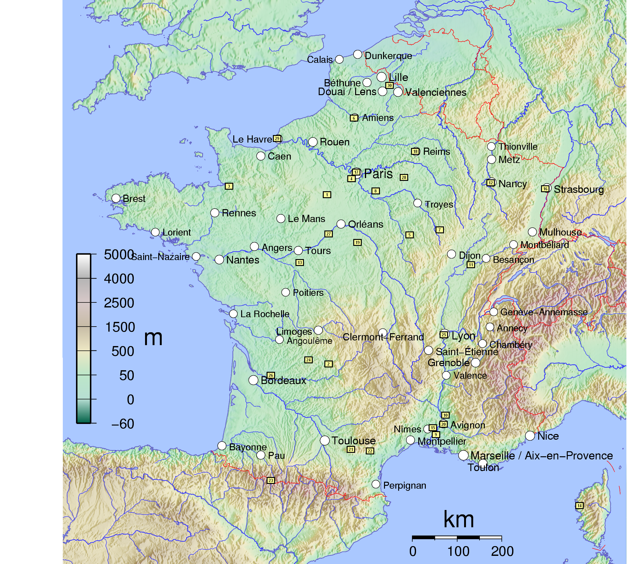
Carte de France sur laquelle apparait les différents sites classés au patrimoine mondial de l'humanité :
- 1: 1979 Cathédrale Notre-Dame de Chartres
- 2: 1979 Grottes ornées de la vallée de la Vézère
- 3: 1979 Mont-Saint-Michel et sa baie
- 4: 1979 Palais et parc du château de Versailles
- 5: 1979 Basilique et colline de Vézelay
- 6: 1981 Cathédrale Notre-Dame d'Amiens
- 7: 1981 Abbaye cistercienne de Fontenay
- 8: 1981 Château et parc de Fontainebleau
- 9: 1981 Monuments romains et romans d'Arles
- 10: 1981 Théâtre antique, ses abords et Arc de Triomphe d'Orange
- 11: 1982 Saline royale d'Arc-et-Senans
- 12: 1983 Places Stanislas, de la Carrière, et d'Alliance à Nancy
- 13: 1983 Église de Saint-Savin-sur-Gartempe
- 14: 1983 Caps de Girolata et de Porto et réserve naturelle de Scandola, calanches de Piana en Corse
- 15: 1985 Pont du Gard
- 16: 1988 Strasbourg - Grande Île
- 17: 1991 Paris, rives de la Seine
- 18: 1991 Cathédrale Notre-Dame, ancienne abbaye Saint-Remi et palais de Tau, Reims
- 19: 1992 Cathédrale Saint-Étienne de Bourges
- 20: 1995 Centre historique d'Avignon
- 21: 1996 Le Canal du Midi
- 22: 1997 Cité de Carcassonne, ville fortifiée historique
- 23: 1997 Le Mont-Perdu dans les Pyrénées
- 24: 1998 Chemins de Saint-Jacques-de-Compostelle en France
- 25: 1998 Site historique de Lyon
- 26: 1999 Juridiction de Saint-Émilion
- 27: 2000 Le Val de Loire entre Sully-sur-Loire et Chalonnes-sur-Loire (*)
- 28: 2001 Provins, ville de foire médiévale
- 29: 2005 Centre-ville du Havre reconstruit par l'architecte Auguste Perret
- 30: 2005 Vingt-trois beffrois du Nord-Pas-de-Calais et de la Somme (**) : Abbeville, Aire-sur-la-Lys, Amiens, Armentières, Arras, Bailleul, Bergues, Béthune, Boulogne-sur-Mer, Calais, Cambrai, Comines, Douai, Doullens, deux à Dunkerque, Gravelines, Hesdin, Lille, Loos, Lucheux, Rue et Saint-Riquier.
Copyright
edit
Image réalisé par mes soins sur le fond de carte http://commons.wikimedia.org/wiki/Image:France_cities.pdf

|
Permission is granted to copy, distribute and/or modify this document under the terms of the GNU Free Documentation License, Version 1.2 or any later version published by the Free Software Foundation; with no Invariant Sections, no Front-Cover Texts, and no Back-Cover Texts. A copy of the license is included in the section entitled GNU Free Documentation License. |
| This file is licensed under the Creative Commons Attribution-Share Alike 3.0 Unported license. | ||
| ||
| This licensing tag was added to this file as part of the GFDL licensing update. |
This file is licensed under the Creative Commons Attribution-Share Alike 1.0 Generic license.
- You are free:
- to share – to copy, distribute and transmit the work
- to remix – to adapt the work
- Under the following conditions:
- attribution – You must give appropriate credit, provide a link to the license, and indicate if changes were made. You may do so in any reasonable manner, but not in any way that suggests the licensor endorses you or your use.
- share alike – If you alter, transform, or build upon this work, you must distribute the resulting work under the same license as the original.
This file is licensed under the Creative Commons Attribution-Share Alike 2.0 France license.
- You are free:
- to share – to copy, distribute and transmit the work
- to remix – to adapt the work
- Under the following conditions:
- attribution – You must give appropriate credit, provide a link to the license, and indicate if changes were made. You may do so in any reasonable manner, but not in any way that suggests the licensor endorses you or your use.
- share alike – If you remix, transform, or build upon the material, you must distribute your contributions under the same or compatible license as the original.

Nepomuk 5 avril 2006 à 22:55 (CEST)
| date/time | username | resolution | size | edit summary |
|---|---|---|---|---|
File history
Click on a date/time to view the file as it appeared at that time.
| Date/Time | Thumbnail | Dimensions | User | Comment | |
|---|---|---|---|---|---|
| current | 09:19, 7 August 2006 | | 2,000 × 1,796 (4.56 MB) | Loveless (talk | contribs) | This image was copied from wikipedia:fr. The original description was: Carte de France sur laquelle apparait les différents sites classés au patrimoine mondial de l'humanité : # 1: 1979 Cathédrale Notre-Dame de Chartres # 2: 1979 Grottes ornées de |
You cannot overwrite this file.
File usage on Commons
The following 2 pages use this file:
File usage on other wikis
The following other wikis use this file:
- Usage on gl.wikipedia.org
- Usage on ka.wikipedia.org
- Usage on uk.wikipedia.org
- Usage on xmf.wikipedia.org