File:Mongols-map.png

Size of this preview: 722 × 599 pixels. Other resolutions: 289 × 240 pixels | 578 × 480 pixels | 925 × 768 pixels | 1,234 × 1,024 pixels | 1,801 × 1,495 pixels.
Original file (1,801 × 1,495 pixels, file size: 2.79 MB, MIME type: image/png)
Captions
Captions
Add a one-line explanation of what this file represents
Summary
edit
| Description |
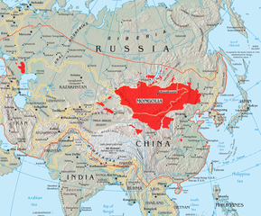
English: A map of the places that Mongol peoples live.
The orange line shows the extent of the Mongol Empire in the late 13th century. The red areas are the places dominated by ethnic Mongols. |
| Date | |
| Source |
|
| Author | Quadell |

|
This linguistic map image could be re-created using vector graphics as an SVG file. This has several advantages; see Commons:Media for cleanup for more information. If an SVG form of this image is available, please upload it and afterwards replace this template with
{{vector version available|new image name}}.
It is recommended to name the SVG file “Mongols-map.svg”—then the template Vector version available (or Vva) does not need the new image name parameter. |
Licensing
edit
I, the copyright holder of this work, hereby publish it under the following licenses:

|
Permission is granted to copy, distribute and/or modify this document under the terms of the GNU Free Documentation License, Version 1.2 or any later version published by the Free Software Foundation; with no Invariant Sections, no Front-Cover Texts, and no Back-Cover Texts. A copy of the license is included in the section entitled GNU Free Documentation License. |
| This file is licensed under the Creative Commons Attribution-Share Alike 3.0 Unported license. | ||
| ||
| This licensing tag was added to this file as part of the GFDL licensing update. |
This file is licensed under the Creative Commons Attribution-Share Alike 2.0 Generic license.
- You are free:
- to share – to copy, distribute and transmit the work
- to remix – to adapt the work
- Under the following conditions:
- attribution – You must give appropriate credit, provide a link to the license, and indicate if changes were made. You may do so in any reasonable manner, but not in any way that suggests the licensor endorses you or your use.
- share alike – If you remix, transform, or build upon the material, you must distribute your contributions under the same or compatible license as the original.
You may select the license of your choice.
File history
Click on a date/time to view the file as it appeared at that time.
| Date/Time | Thumbnail | Dimensions | User | Comment | |
|---|---|---|---|---|---|
| current | 14:37, 29 May 2023 | | 1,801 × 1,495 (2.79 MB) | Artanisen (talk | contribs) | High resolution map with the same borders and areas as version 17:34, 16 July 2005 (UTC) |
| 20:13, 10 April 2021 |  | 728 × 525 (279 KB) | Fæ (talk | contribs) | Reverted to version as of 17:34, 16 July 2005 (UTC) Untrusted work of sockpuppets | |
| 03:35, 17 January 2019 |  | 728 × 525 (295 KB) | Anchuhu (talk | contribs) | mongol | |
| 10:56, 22 June 2017 |  | 728 × 525 (630 KB) | 일성강 (talk | contribs) | Reverted to version as of 12:47, 1 June 2017 (UTC) | |
| 08:54, 17 June 2017 |  | 728 × 525 (279 KB) | Calthinus (talk | contribs) | Reverted to version as of 17:34, 16 July 2005 (UTC) | |
| 12:47, 1 June 2017 |  | 728 × 525 (630 KB) | 일성강 (talk | contribs) | fixed | |
| 17:34, 16 July 2005 |  | 728 × 525 (279 KB) | Hottentot~commonswiki (talk | contribs) | This is a map of the places that Mongol peoples live. The information is based off of w:en:Image:Mongolsethnic.jpg, and the map I started with is w:en:Image:Asia-map.png. The orange line shows the extent of the Mongol Empire in the late 13th c | |
| 13:14, 16 July 2005 |  | 728 × 525 (297 KB) | Quadell (talk | contribs) | This is a map of the places that Mongol peoples live. The information is based off of [:w:en:Image:Mongolsethnic.jpg]], and the map I started with is w:en:Image:Asia-map.png. The orange line shows the extent of the Mongol Empire in the late 13th ce |
You cannot overwrite this file.
File usage on Commons
The following 13 pages use this file:
- Atlas of Mongolia
- Top 200 map images that should use vector graphics
- Монгол улс
- User:Chumwa/OgreBot/Travel and communication maps/2017 June 1-10
- User:Chumwa/OgreBot/Travel and communication maps/2017 June 11-20
- User:Chumwa/OgreBot/Travel and communication maps/2017 June 21-30
- User:Chumwa/OgreBot/Travel and communication maps/2019 January 11-20
- User:Chumwa/OgreBot/Travel and communication maps/2021 April 1-10
- User:Chumwa/OgreBot/Travel and communication maps/2023 May 21-31
- User:Yug/China
- File:Civilisations actuelles.png
- Category:Mongolian language
- Category:Mongolic peoples
File usage on other wikis
The following other wikis use this file:
- Usage on af.wikipedia.org
- Usage on an.wikipedia.org
- Usage on ar.wikipedia.org
- Usage on arz.wikipedia.org
- Usage on ast.wikipedia.org
- Usage on azb.wikipedia.org
- Usage on az.wikipedia.org
- Usage on ba.wikipedia.org
- Usage on be-tarask.wikipedia.org
- Usage on be.wikipedia.org
- Usage on bg.wiktionary.org
- Usage on bh.wikipedia.org
- Usage on bn.wikivoyage.org
- Usage on br.wikipedia.org
- Usage on bs.wikipedia.org
- Usage on ca.wikipedia.org
- Usage on ca.wiktionary.org
- Usage on ckb.wikipedia.org
- Usage on cs.wikipedia.org
- Usage on cv.wikipedia.org
- Usage on da.wikipedia.org
- Usage on diq.wikipedia.org
- Usage on dsb.wikipedia.org
- Usage on el.wikipedia.org
- Usage on en.wikipedia.org
View more global usage of this file.