File:MasbateLocation.png
Size of this preview: 274 × 598 pixels. Other resolutions: 110 × 240 pixels | 328 × 716 pixels.
Original file (328 × 716 pixels, file size: 34 KB, MIME type: image/png)
Captions
Captions
Add a one-line explanation of what this file represents
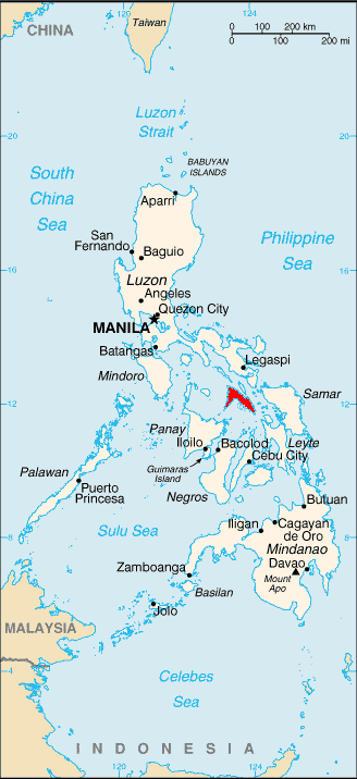
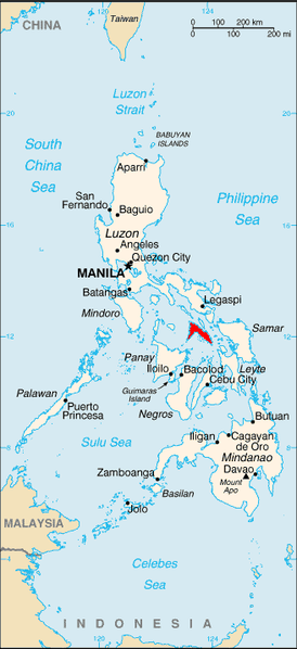
| Description | Locateion of island of Masbate |
| Date | |
| Source | http://commons.wikimedia.org/wiki/Image:Rp-map.png |
| Author | Central Intelligence Agency, Vitor |
| Permission (Reusing this file) |
PD |
This image is in the public domain because it contains materials that originally came from the United States Central Intelligence Agency's World Factbook.
|
 |
File history
Click on a date/time to view the file as it appeared at that time.
| Date/Time | Thumbnail | Dimensions | User | Comment | |
|---|---|---|---|---|---|
| current | 11:54, 3 April 2008 | | 328 × 716 (34 KB) | Vitor pk (talk | contribs) | {{Information |Description=Locateion of island of Masbate |Source=http://commons.wikimedia.org/wiki/Image:Rp-map.png |Date=2008-04-04 |Author=Central Intelligence Agency, Vitor |Permission=PD |other_versions= }} {{PD-USGov-CIA-WF}} [[Cat |
You cannot overwrite this file.
File usage on Commons
There are no pages that use this file.
File usage on other wikis
The following other wikis use this file:
- Usage on az.wikipedia.org
- Usage on be.wikipedia.org
- Usage on mrj.wikipedia.org
- Usage on nl.wikipedia.org
- Usage on pl.wikivoyage.org
- Usage on ru.wikipedia.org
- Usage on sr.wikipedia.org
- Usage on uk.wikipedia.org