File:French India 1741-1754.png
Size of this preview: 486 × 599 pixels. Other resolutions: 195 × 240 pixels | 389 × 480 pixels | 623 × 768 pixels | 1,044 × 1,287 pixels.
Original file (1,044 × 1,287 pixels, file size: 200 KB, MIME type: image/png)
Captions
Captions
Add a one-line explanation of what this file represents
Summary
edit
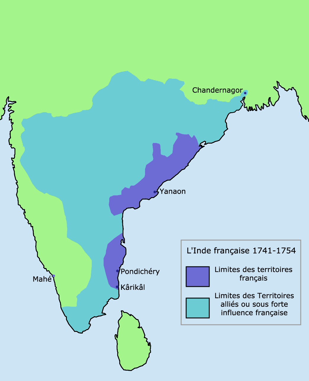
French control and influence in India 1741-1754, based on information from [1]. Map is decently neutral: It is subjective to the old cartographer but the user has depicted it accurately as the British spheres of influence in the map source are after or during the 7 years war, which the author user states in his map.
![[1]](https://homepages.rootsweb.com/~poyntz/India/images/india_shepherd_1923.jpg)
Licensing
edit
I, the copyright holder of this work, hereby publish it under the following license:

|
Permission is granted to copy, distribute and/or modify this document under the terms of the GNU Free Documentation License, Version 1.2 or any later version published by the Free Software Foundation; with no Invariant Sections, no Front-Cover Texts, and no Back-Cover Texts. A copy of the license is included in the section entitled GNU Free Documentation License. |
| This file is licensed under the Creative Commons Attribution-Share Alike 3.0 Unported license. | ||
| ||
| This licensing tag was added to this file as part of the GFDL licensing update. |
File history
Click on a date/time to view the file as it appeared at that time.
| Date/Time | Thumbnail | Dimensions | User | Comment | |
|---|---|---|---|---|---|
| current | 13:33, 18 March 2011 | | 1,044 × 1,287 (200 KB) | Hypersite (talk | contribs) | L'ancienne version de la carte n'était pas correcte, j'en est donc fait une nouvelle respectant plus les données de l'époque avec des ajout de territoires dans l'est et des réduction dans l'ouest, j'ai utiliser pour model plusieurs données dont une c |
| 13:03, 13 May 2006 |  | 1,044 × 1,287 (46 KB) | Roke~commonswiki (talk | contribs) | French control and influence in India 1741-1754, based on information from [http://homepages.rootsweb.com/~poyntz/India/images/india_shepherd_1923.jpg] Category: Historical maps of India |
You cannot overwrite this file.
File usage on Commons
The following 2 pages use this file:
File usage on other wikis
The following other wikis use this file:
- Usage on af.wikipedia.org
- Usage on ar.wikipedia.org
- Usage on az.wikipedia.org
- Usage on ba.wikipedia.org
- Usage on bg.wikipedia.org
- Usage on bn.wikipedia.org
- Usage on cs.wikipedia.org
- Usage on de.wikipedia.org
- Usage on en.wikipedia.org
- Usage on eo.wikipedia.org
- Usage on es.wikipedia.org
- Usage on eu.wikipedia.org
- Usage on fa.wikipedia.org
- Usage on fr.wikipedia.org
- Usage on he.wikipedia.org
- Usage on hi.wikipedia.org
- Usage on hu.wikipedia.org
- Usage on hy.wikipedia.org
- Usage on id.wikipedia.org
- Usage on it.wikipedia.org
- Usage on ja.wikipedia.org
- Usage on li.wikipedia.org
- Usage on lv.wikipedia.org
- Usage on nl.wikipedia.org
- Usage on nn.wikipedia.org
View more global usage of this file.