File:Honduras mapa uk.png
No higher resolution available.
Honduras_mapa_uk.png (330 × 354 pixels, file size: 12 KB, MIME type: image/png)
Captions
Captions
Add a one-line explanation of what this file represents
| Description |
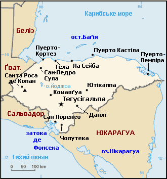
Українська: Мапа Гондурасу. |
||||||||
| Date | |||||||||
| Source | Перекладена з мапи ЦРУ. | ||||||||
| Author | Перекладене користувачем Vlad. | ||||||||
| Permission (Reusing this file) |
|

Original upload log
edit
Transferred from uk.wikipedia to Commons using UWCTransferBot v.2.1.2 based on Chris G's botclasses framework.
The original description page was here. All following user names refer to uk.wikipedia.
- 2006-11-09 20:26 Oleksii0 330×354×8 (12058 bytes) Незначна корекція
- 2005-10-25 18:42 Vlad 330×354×8 (9793 bytes) Мапа Гондурасу.___________________________________________ Зображення було отримане з цру(cia worldfact book).Копіювання дозволене.Перекладене користувачем сайту.
File history
Click on a date/time to view the file as it appeared at that time.
| Date/Time | Thumbnail | Dimensions | User | Comment | |
|---|---|---|---|---|---|
| current | 22:00, 14 March 2015 | | 330 × 354 (12 KB) | UWCTransferBot (talk | contribs) | file was transfered from Ukrainian Wikipedia |
You cannot overwrite this file.
File usage on Commons
There are no pages that use this file.
File usage on other wikis
The following other wikis use this file:
- Usage on uk.wikipedia.org