卡奔塔利亞灣
卡奔塔利亚湾()是澳大利亚北部的一个长方形浅水海湾,三面环陆,北面是阿拉弗拉海(一个在澳大利亚与新几内亚之间的水体)。面积31万平方千米,东西最大宽度670千米,南北长600千米,最深处为70米。底部是澳大利亚和新几内亚的大陆架。南部有韦尔斯利群岛,西南部有爱德华·佩柳爵士群岛,西部有格鲁特岛。海湾底部坡度小,有20多条河流汇入,下游大都蜿蜒曲折,多产生三角洲。[1]
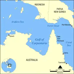
卡奔塔利亚湾地图。
从地质学角度来说,卡奔塔利亚湾相当年轻,在上一次冰河时期,它还是干涸的。包围卡奔塔利亚湾的陆地较平坦,地势较低。其西面是阿纳姆地,东面是约克角半岛,南面则是昆士兰州的一部分。
此海以彼得·德·卡彭蒂耶的名字命名。
商業活動
参考
- 季任钧 罗浩. . 《中国大百科全书》(第二版). 中国大百科全书出版社. [2020-10-02] (中文(中国大陆)).
- Tomascik, Tomas; Anmarie Janice Mah; Anugerah Nontji; Mohammad Kasin Moosa. . Periplus Editions. 1997: 829 [17 November 2011]. ISBN 962-593-163-5. (原始内容存档于2016-06-10).
- Ian Townsend. . PM (radio program) (Australian Broadcasting Corporation). 18 April 2005 [28 September 2012]. (原始内容存档于2017-05-12).
- Paul Sutherland. . ABC News (Australian Broadcasting Corporation). 10 November 2011 [28 September 2012]. (原始内容存档于2013-05-11).
外部連結
| 维基共享资源上的相关多媒体资源:卡奔塔利亞灣 |
| 英文维基文库中的《1911年版大英百科全書》條目:Gulf of Carpentaria |
- Morning Glory Cloud video footage(页面存档备份,存于) and video of the Gulf Region around Burketown
- Morning Glory Cloud meteorology(页面存档备份,存于)
- Aerial Video of Sweers Island in the Gulf of Carpentaria(页面存档备份,存于)
- Video of Burketown and the Gulf from the air(页面存档备份,存于)
- Video of discovery of coral reefs in the Gulf of Carpentaria(页面存档备份,存于)
This article is issued from Wikipedia. The text is licensed under Creative Commons - Attribution - Sharealike. Additional terms may apply for the media files.