- Dat artikel es geschreevn in 't Noordelik West-Vlams.
 | |
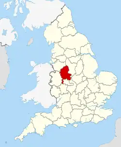 Liggienge van Staffordshire in Iengeland | |
| Regio | West Midlands |
| Stoatus | Non-metropolitan en ceremonieel |
| Hoofdplekke | Stafford |
| Coördinoatn | {{{latitudeGraden}}}°{{{latitudeMinuten}}}′NB {{{longitudeGraden}}}°{{{longitudeMinuten}}}′WL |
| Ippervlak | 2.620 km² |
| Inweuners | 875.219 |
| {{{foto}}} {{{byschrift}}} | |
Staffordshire is e groafschap in de West Midlands in Iengeland. D' hoofdplekke is Stafford.
Staffordshire grenst in 't noordwestn an Cheshire, in 't oostn an Derbyshire en Leicestershire, in 't zuudoostn an Warwickshire, in 't zuudn an West Midlands en Worcestershire en in 't westn an Shropshire.
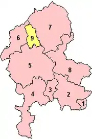
Districtn
| Districtn | Detailkoarte |
|---|---|
|
 |
Belangrykste plekkn
- Stoke-on-Trent
- Lichfield
- Burton-upon-Trent
- Newcastle-under-Lyme
- Tamworth
- Stafford
Beziensweirdigheedn
- Ancient High House in Stafford
- Cannock Chase, Area of Outstanding Natural Beauty
- Izaak Walton's Cottage in Chebsey, 17e eeuwe
- Kathedroale van Lichfield, middeleeuwsche, gotische, anglicoansche kathedroale
- Romeynsche Site in Wall
- Shugborough Hall, Iengels landhuus by Great Haywood
- Stafford Castle
- Tamworth Castle

Ancient High House in Stafford 
Kathedroale van Lichfield 
Overbluufsels van Letocetum, Romeynsche vestigienge in 't dorp Wall 
Shugborough Hall 
Tamworth Castle
This article is issued from Wikipedia. The text is licensed under Creative Commons - Attribution - Sharealike. Additional terms may apply for the media files.