| Warwickshire | |||
|---|---|---|---|
| — Coontae jesh-chliaghtagh — | |||
|
|||
 Soiaghey Warwickshire er caslys-çheerey Hostyn |
|||
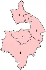 Slystyn Warwickshire: 1) Warwickshire Hwoaie 2) Nuneaton as Bedworth 3) Rugby 4) Stratford-on-Avon 5) Warwick |
|||
| Co-ordnaidyn: 52°18′N 01°34′W / 52.3°N 1.567°W | |||
| Çheer | |||
| Çheer cho-ayrnagh | |||
| Ard | Mean-çheerey Heear | ||
| Ard-oik reiragh | Warwick | ||
| Reiltys | |||
| - Colught | Coonseil Coontae Warwickshire | ||
| - MPyn | 6 |
||
| Eaghtyr | |||
| - Yn clane | 1,975 km² (762.6 mi ker) | ||
| Earroo yn phobble (2008)[1] | |||
| - Yn clane | 530,500 | ||
| - Glooaght y phobble | 269/km² (696.7/mi ker) | ||
| Cryss hraa | GMT (UTC+0) | ||
| - Sourey (TTSL) | BST (UTC+1) | ||
| ISO 3166-2 | GB-WAR | ||
| Coad ONS | 44 | ||
| NUTS 3 | UKG13 | ||
| Ynnyd-eggey | www.warwickshire.gov.uk | ||

She coontae reiragh as jesh-chliaghtagh ayns Mean-çheerey Heear Hostyn eh Warwickshire. T'eh çhemmit liorish Mean-çheerey Heear Hostyn as Staffordshire da'n çheear hwoaie, Leicestershire da'n çhiar hwoaie, Northamptonshire da'n çhiar, Sheer Aah yn Ollee da'n jiass, Gloucestershire da'n çhiar yiass, as Worcestershire da'n çheear.
Ta queig slystyn echey: Warwickshire Hwoaie, Nuneaton as Bedworth, Rugby, Stratford-on-Avon, as Warwick hene. Cha nel caayr erbee 'sy choontae erreish da Coventry as Birmingham goll er covestey ayns Mean-çheerey Heear Hostyn ayns 1974.
Imraaghyn
- ↑ Population estimates for UK, England and Wales, Scotland and Northern Ireland, Mid-2008. National Statistics Online. Office for National Statistics.
|
|
She bun ta'n art shoh. Cur rish, son foays y yannoo da Wikipedia. |
This article is issued from Wikipedia. The text is licensed under Creative Commons - Attribution - Sharealike. Additional terms may apply for the media files.