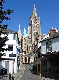
| Truru Truro |
|
|---|---|
| — Caayr as Skeerey ny Theay — | |
 Agglish Truru ass Straid Voirrey Noo |
|
[[File:England location map.svg|250px|{{#if:||{{#if:Truru|Truru|Truru er caslys-çheerey]] Truru |
|
[[File:Cornwall UK mainland location map.svg|250px|{{#if:||{{#if:Truru|Truru|Truru er caslys-çheerey]] Truru |
|
| Co-ordnaidyn: 50°15′36″N 5°3′3.6″W / 50.26°N 5.051°W | |
| Çheer | |
| Çheer cho-ayrnagh | |
| Ard | Sostyn Heear Yiass |
| Coontae jesh-chliaghtagh | |
| Lught-reill unnaneagh | Yn Chorn |
| Reiltys | |
| - Sorçh | Caayr |
| - Coonceil | Coonceil Chaayragh Hruro |
| - Çhiarn-Veoir | Rob Nolan |
| Eaghtyr | |
| - Yn clane | 35.69 km² (13.8 mi ker) |
| Earroo yn phobble (2001) | |
| - Yn clane | 20,920 |
| - Glooaght y phobble | 2,398/km² (6,210.8/mi ker) |
| Cryss hraa | Traa Mean Ghreenwich (UTC+0) |
| - Sourey (TTSL) | Traa Houree Ghoaldagh (UTC+1) |
| Postcode | TR1-4 |
| Coad(yn) çhellvane | 01872 |
| Coad OS | SW825448 |
| Rheynn-reih ny h-Oarpey | Sostyn Heear Yiass |
| Rheynn-reih Ard-whaiyl y RU | Truru as Aberfal |
| Ynnyd-eggey | www.truro.gov.uk |
She preeu-valley ny Corn eh Truru (Baarle: Truro). T'eh ny skeerey theayagh as ny chaayr 'sy Chorn, nane jeh ny coondaeghyn jesh-chliaghtagh ayns Sostyn, y Reeriaght Unnaneysit. Ta 17,431 deiney cummal 'sy chaayr as 20,920 deiney cummal 'syn ard staydraaoil baljagh rere y choontey-pobble 'sy vlein 2001. Cha nel caayr elley 'sy Chorn as t'eh ny chaayr smoo jiassagh 'sy Vretyn Vooar.
|
|
She bun ta'n art shoh. Cur rish, son foays y yannoo da Wikipedia. |
This article is issued from Wikipedia. The text is licensed under Creative Commons - Attribution - Sharealike. Additional terms may apply for the media files.