| Hertfordshire | |||
|---|---|---|---|
| — Coontae jesh-chliaghtagh — | |||
|
|||
 Soiaghey Hertfordshire er caslys-çheerey Hostyn |
|||
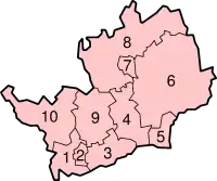 Slystyn Hertfordshire: 1) Three Rivers 2) Watford 3) Hertsmere 4) Welwyn Hatfield 5) Broxbourne 6) Hertfordshire Hiar 7) Stevenage 8) Hertfordshire Hwoaie 9) Caayr St Albans 10) Dacorum |
|||
| Co-ordnaidyn: 51°54′N 00°12′W / 51.9°N 0.2°W | |||
| Çheer | |||
| Çheer cho-ayrnagh | |||
| Ard | Sostyn Hiar | ||
| Ard-oik reiragh | Hertford | ||
| Reiltys | |||
| - Colught | Coonseil Coontae Hertfordshire | ||
| - MPyn | 11 |
||
| Eaghtyr | |||
| - Yn clane | 1,643 km² (634.4 mi ker) | ||
| Earroo yn phobble (2008)[1] | |||
| - Yn clane | 1,078,400 | ||
| - Glooaght y phobble | 656/km² (1,699/mi ker) | ||
| Cryss hraa | GMT (UTC+0) | ||
| - Sourey (TTSL) | BST (UTC+1) | ||
| ISO 3166-2 | GB-HRT | ||
| Coad ONS | 26 | ||
| NUTS 3 | UKH23 | ||
| Ynnyd-eggey | www.hertsdirect.org | ||

She coontae jesh-chliaghtagh as neuvoirvaljagh ayns Sostyn Hiar eh Hertfordshire. T'eh çhemmit liorish Bedfordshire da'n twoaie, Cambridgeshire da'n çhiar yiass, Essex da'n çhiar, Lunnin Vooar da'n jiass, as Buckinghamshire da'n çheear.
Ta jeih lughtyn-reilley 'sy choontae jesh-chliaghtagh: Three Rivers, Watford, Hertsmere, Welwyn Hatfield, Broxbourne, Hertfordshire Hiar, Stevenage, Hertfordshire Hwoaie, St Albans, as Dacorum.
Imraaghyn
- ↑ Population estimates for UK, England and Wales, Scotland and Northern Ireland, Mid-2008. National Statistics Online. Office for National Statistics.
|
|
She bun ta'n art shoh. Cur rish, son foays y yannoo da Wikipedia. |
This article is issued from Wikipedia. The text is licensed under Creative Commons - Attribution - Sharealike. Additional terms may apply for the media files.