| Essex | |||
|---|---|---|---|
| — Coontae jesh-chliaghtagh — | |||
|
|||
 Soiaghey Essex er caslys-çheerey Hostyn |
|||
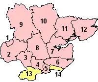 Slystyn Essex: 1) Harlow 2) Epping Forest 3) Brentwood 4) Basildon 5) Castle Point 6) Rochford 7) Maldon 8) Chelmsford 9) Uttlesford 10) Braintree 11) Colchester 12) Tendring 13) Thurrock (Unnaneagh) 14) Southend-on-Sea (Unnaneagh) |
|||
| Co-ordnaidyn: 51°55′04″N 00°28′22″E / 51.91778°N 0.47278°E | |||
| Çheer | |||
| Çheer cho-ayrnagh | |||
| Ard | Sostyn Hiar | ||
| Ard-oik reiragh | Chelmsford | ||
| Reiltys | |||
| - Colught | Coonseil Coontae Essex | ||
| - MPyn | 18 |
||
| Eaghtyr | |||
| - Yn clane | 3,670 km² (1,417 mi ker) | ||
| Earroo yn phobble (2008)[1] | 1,712,200 | ||
| - Glooaght y phobble | 467/km² (1,209.5/mi ker) | ||
| Cryss hraa | GMT (UTC+0) | ||
| - Sourey (TTSL) | BST (UTC+1) | ||
| ISO 3166-2 | GB-ESS | ||
| Coad ONS | 22 | ||
| NUTS 3 | UKH33 | ||
| Ynnyd-eggey | www.essex.gov.uk | ||


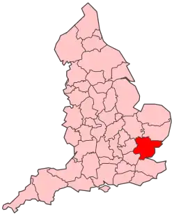
She coontae jesh-chliaghtagh as neuvoirvaljagh ayns Sostyn Hiar eh Essex. T'eh çhemmit liorish Suffolk da'n çhiar hwoaie, Kent da'n jiass, Lunnin Vooar da'n çheear yiass, Hertfordshire da'n çheear, as Cambridgeshire da'n çheear hwoaie.
Ta kiare lughtyn-reilley jeig 'sy choontae jesh-chliaghtagh: Epping Forest, Brentwood, Basildon, Castle Point, Rochford, Maldon, Chelmsford, Uttlesford, Braintree, Colchester, Tendring, Thurrock as Southend-on-Sea. Ta Thurrock as Southend-on-Sea nyn lughtyn-reilley unnaneagh nagh vel fo stiuredys y choonceil choontae.
Imraaghyn
- ↑ Population estimates for UK, England and Wales, Scotland and Northern Ireland, Mid-2008. National Statistics Online. Office for National Statistics.
|
|
She bun ta'n art shoh. Cur rish, son foays y yannoo da Wikipedia. |
This article is issued from Wikipedia. The text is licensed under Creative Commons - Attribution - Sharealike. Additional terms may apply for the media files.