- She yn balley ayns Coontae ny Mee bun-chooish y duillag shoh. My vel anaase ayd ayns baljyn elley lesh yn ennym cheddin oc, lhaih Ceanannas (reddaghey).
| Ceanannas Kells (en) |
|||
|---|---|---|---|
| — Balley — | |||
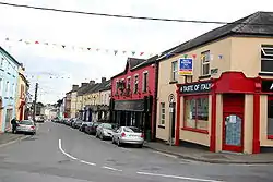 Sráid an Mhargaidh ("Straid y Vargey"), Ceanannas |
|||
|
|||
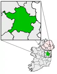
[[File:Ireland location map.svg|250px|{{#if:||{{#if:Ceanannas|Ceanannas|Ceanannas, Coontae yn Vee er caslys-çheerey]] Ceanannas |
|||
| Co-ordnaidyn: 53°43′41″N 06°52′41″W / 53.72806°N 6.87806°W | |||
| Çheer | |||
| Queiggey | |||
| Coontae | Yn Vee | ||
| Dáil Éireann | Yn Vee Heear | ||
| Parlamaid yn Oarpey | Shiar | ||
| Eaghtyr[1] | |||
| - Balley | 1.11 km² (0.4 mi ker) | ||
| Yrjid | 77 m (253 tr) | ||
| Earroo yn phobble (2011)[2] | |||
| - Balley | 2,211 | ||
| - Glooaght y phobble | 1,991.9/km² (5,159/mi ker) | ||
| - Binn | 4,265 | ||
| Cryss hraa | WET (UTC+0) | ||
| - Sourey (TTSL) | IST (UTC+1) | ||
| Coad(yn) çhellvane | +353 46 | ||
| Ingagh ogheragh Nerin | N738759 | ||

Ta Ceanannas ny Ceanannas Mór (Baarle: Kells) ny valley ayns Coontae yn Vee, Nerin. Ta'n balley ny lhie er yn N3, 16 km sheear hwoaie veih'n Ooive as 65 km veih Divlyn.
Imraaghyn
- ↑ "Table 6 - Population and area of each Province, County, City, urban area, rural area and Electoral Division, 2002 and 2006" (PDF). Census 2006, Volume 1 - Population Classified by Area. Oik Staydraa Nerin. 2007-04-26. dgn. d. 71. Feddynit magh er 2010-07-25. (Baarle)
- ↑ "Actual and percentage change in population 2006 to 2011 by Province County City Urban area Rural area and Electoral division by District, Year and Statistic 2011". Census 2011 - Preliminary results. Príomh Oifig Staidrimh na hÉireann. 2011. Feddynit magh er 16 Jerrey Souree 2011. (Baarle)
This article is issued from Wikipedia. The text is licensed under Creative Commons - Attribution - Sharealike. Additional terms may apply for the media files.