| Baile Mhic Gormáin Gormanston (en) |
|
|---|---|
 Thie Oast The Huntsman ("Y Shelgeyr") ayns Baile Mhic Gormáin |
|
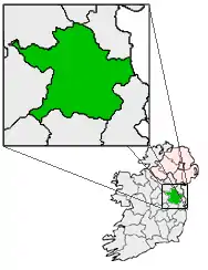
[[File:Ireland location map.svg|250px|{{#if:||{{#if:Baile Mhic Gormáin|Baile Mhic Gormáin|Baile Mhic Gormáin er caslys-çheerey]] Baile Mhic Gormáin |
|
| Co-ordnaidyn: 53°38′12″N 06°14′03″W / 53.63667°N 6.23417°W | |
| Çheer | |
| Queiggey | |
| Coontae | Yn Vee |
| Dáil Éireann | Yn Vee Hiar |
| Parlamaid yn Oarpey | Shiar |
| Yrjid | 18 m (59 tr) |
| Earroo yn phobble (2006)[1] | |
| - Yn clane | 355 |
| Cryss hraa | WET (UTC+0) |
| - Sourey (TTSL) | IST (UTC+1) |
| Coad(yn) çhellvane | +353 1 |
Ta Baile Mhic Gormáin (Baarle: Gormanston) ny valley beg as ayns Coontae yn Vee, Nerin. Ta'n balley beg ny hoie er gerrey da'n joarey rish Coontae Ghivlyn ayns shiar y choontae.
Imraaghyn
- ↑ "Table 12 Alphabetical list of Towns with their population, 2002 and 2006" (PDF). Census 2006, Volume 1 - Areas (ayns Baarle). Príomh Oifig Staidrimh na hÉireann. 2007-04-26. dgn. d. 140. Feddynit magh er 2011-07-18.
{{cite web}}: CS1 maint: çhengey gyn enney (link) (Baarle)
This article is issued from Wikipedia. The text is licensed under Creative Commons - Attribution - Sharealike. Additional terms may apply for the media files.