| Saint-Ségal | |
 | |
| Verwàltung | |
|---|---|
| Land | |
| Region | |
| Département | Finistère (29) |
| Arrondissement | Châteaulin |
| Kànton | Pont-de-Buis-lès-Quimerch |
| Kommünàlverbànd | Pleyben-Châteaulin-Porzay |
| Àmtliga Nàma | Saint-Ségal |
| Maire | Frederic Drelon (2014-2020)[1] |
| Code Insee | 29263 |
| Poschtlaitzàhl | 29590 |
| Iiwohner | |
| Iiwohner | 1.140 |
| Flech | 16,20 km2 |
| Bevelkerungsdicht | 63,27 Iiw./km2 |
| Làg | |
| Koordinate | 48° 14′ 28″ N, 4° 04′ 02″ W / 48.241111111111°N,4.0672222222222°WKoordinate: 48° 14′ 28″ N, 4° 04′ 02″ W / 48.241111111111°N,4.0672222222222°W |
| Heche | 109 m |
 Saint-Ségal Saint-Ségal (Frànkrich) | |
| Website | |
| http://www.mairie-saintsegal.fr | |
Saint-Ségal (bretonisch Sant-Segal) isch e franzesischi Gmai im Département Finistère in dr Region Bretagne.
D Gmai ghert zum Kanton Pont-de-Buis-lès-Quimerch un zum Arrondissement Châteaulin.
Geografi
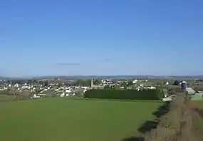
Saint-Ségal lyt 27 km vu Quimper un 36 km vu Brest uf ere Hechi zwische 2 m un 140 m iber Normalnull.
Gschicht
Saint-Ségal isch zum erschte Mol gnännt wore anne 1368 as Seint Sengar (1368 Seintertesengar, 1395 (Saint) Staegal, 1405 Sant Segall, 1516 Sainct Segal, 1536 Sainct Segal, 1630 S. Egal).
Verwaltig
Dr Maire vu Saint-Ségal isch dr Frederic Drelon. Saint-Ségal ghert zum Kommunalverband Pleyben-Châteaulin-Porzay.
Bevelkerigsentwicklig
| Johr | 1962 | 1968 | 1975 | 1982 | 1990 | 1999 | 2008 |
| Inwohner | 746 | 677 | 675 | 745 | 813 | 825 | 963 |
Dialekt
Dr traditionäll Dialäkt vu Saint-Ségal ghert zem Bretonisch.
Kultur un Böuwärch
- Chilche Saint-Séverin (1896-97) un Calvaire
- Kapäll Saint-Sébastien (16. Jh.) un Calvaire
- Reemische Myylestai
- Stele us dr Yysezyt
Bilder
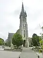
Chilche Saint-Séverin 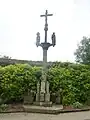
Calvaire 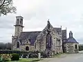
Kapäll Saint-Sébastien 
Dotedänkmol
Weblink
Fueßnote
- ↑ Liste des maires au 25 avril 2014 (data.gouv.fr)
This article is issued from Wikipedia. The text is licensed under Creative Commons - Attribution - Sharealike. Additional terms may apply for the media files.